

408
Characterizing the Human Imprint on Landscapes for Ecological Assessment
licates of Landsat Multispectral Scanner (MSS)
data, called North American Landscape Characterization (NALC) data and representing conditions in
the early 1970s, rnid-1980s, and early 1990s
(Lunetta et aI., 1998). Metrics of spatial pattern discussed in the landscape ecology literature (McGarigal and Marks, 1993) are being applied to characterize forest landscape patterns (Brown et aI.,
2000a). These patterns are being linked to information on land use, land ownership, demographics, economics, and institutional factors through
empirical and modeling approaches (Brown et aI.,
2000b).
27.2.4 Cultural, Esthetic, Spiritual, and
Scientific Resources
Although several features within an ecosystem may
have the same apparent ecological significance, the
value placed on these features may vary due to factors entirely unrelated to ecosystem function. Sites
can have a relatively higher value because of their
scientific value, historical or prehistorical significance, or esthetic value or some spiritual value.
These resources affect the way in which ecosystems have been managed, are being managed, and
will be managed in the future. These sites are often given special use designations, which legally
limit the range of permitted activities. Although the
value placed on the resource is intangible, in many
cases the object of value is, in fact, quite tangible
and it may have been managed or treated quite differently. For example, the Black Hills of South
Dakota, and particular segments, have had a high
spiritual importance to the Lakota (Sioux) people
of North America (Geores, 1996), and this fact has
led to conflicts with European descendants regarding the management of this ecosystem. The spiritual importance of features or ecosystems can only
be understood through qualitative assessment, such
as through surveys or interviews.
Alternatively, segments of an ecosystem may
have higher value simply because they are rare or
unique. For example, rare oak openings in southern Michigan are home to the endangered Kamer
blue butterfly (Lycaeides melissa samuelis). Ecosystem features may have high scientific value because of the uninvestigated properties of the species
present. Their relative value in terms of ecosystem
function may be unknown, and they may need to
be preserved for scientific scrutiny. Also of scientific value is any archeological evidence that may
be in place. An effort should be made, and in some
cases is legislated, to preserve or catalog such cultural resources.
Information about resources with high cultural
value is, by its nature, difficult to obtain and quantify. Known sites of archeological interest are often recorded and mapped. In the United States,
state historical offices can be contacted to acquire
some of this information. GIS-based models have
been used by archeologists in an attempt to predict the locations of culturally important sites,
based on a variety of site and situation factors
(Dolanski, 1997). Sites of particular spiritual or esthetic value mayor may not be designated as parks
or reserves. Boundaries of most federal, state and
local parks, reserves, and other areas designated
for special use are available with the USGS DLGs
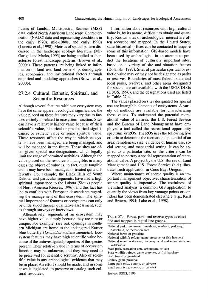
(USGS, 1990), and the designations used are listed
in Table 27.4.
The values placed on sites designated for special
use are intangible elements of ecosystems. A variety of methods are available for characterizing
these values. To understand the potential recreational value of an area, the U.S. Forest Service
and the Bureau of Land Management have employed a tool called the recreational opportunity
spectrum, or ROS. The ROS uses the following five
criteria to determine the recreational potential of an
area: remoteness, size, evidence of human use, social setting, and managerial setting. It can be applied to a particular site, or the criteria can be
mapped to portray a spatial representation of recreational value. A project by the U.S. Bureau of Land
Management and U.S. Forest Service (n.d.) illustrates such application in Coos Bay, Oregon.
Where maintenance of scenic quality is an important management objective, characterization of
scenic quality is imperative. The usefulness of
viewshed analysis, a common GIS application, to
quantify the views from key vantage points or corridors has been demonstrated elsewhere (e.g., Krist
and Brown, 1994; Lake et aI., 1998).
TABLE 27.4. Forest, park, and reserve types as classified and mapped in digital line graphs.
National park, monument, lakeshore, seashore, parkway,
battlefield, or recreation area
National forest or grassland
National wildlife refuge, game preserve, or fish hatchery
National scenic waterway, riverway, wild and scenic river, or
wilderness
State park, recreation area, arboretum, or lake
State wildlife refuge, game preserve, or fish hatchery
State forest or grassland
County game preserve
Large park (city, county, or private)
Small park (city, county, or private)
Source: USGS, 1990.
Characterizing the Human Imprint on Landscapes for Ecological Assessment
licates of Landsat Multispectral Scanner (MSS)
data, called North American Landscape Characterization (NALC) data and representing conditions in
the early 1970s, rnid-1980s, and early 1990s
(Lunetta et aI., 1998). Metrics of spatial pattern discussed in the landscape ecology literature (McGarigal and Marks, 1993) are being applied to characterize forest landscape patterns (Brown et aI.,
2000a). These patterns are being linked to information on land use, land ownership, demographics, economics, and institutional factors through
empirical and modeling approaches (Brown et aI.,
2000b).
27.2.4 Cultural, Esthetic, Spiritual, and
Scientific Resources
Although several features within an ecosystem may
have the same apparent ecological significance, the
value placed on these features may vary due to factors entirely unrelated to ecosystem function. Sites
can have a relatively higher value because of their
scientific value, historical or prehistorical significance, or esthetic value or some spiritual value.
These resources affect the way in which ecosystems have been managed, are being managed, and
will be managed in the future. These sites are often given special use designations, which legally
limit the range of permitted activities. Although the
value placed on the resource is intangible, in many
cases the object of value is, in fact, quite tangible
and it may have been managed or treated quite differently. For example, the Black Hills of South
Dakota, and particular segments, have had a high
spiritual importance to the Lakota (Sioux) people
of North America (Geores, 1996), and this fact has
led to conflicts with European descendants regarding the management of this ecosystem. The spiritual importance of features or ecosystems can only
be understood through qualitative assessment, such
as through surveys or interviews.
Alternatively, segments of an ecosystem may
have higher value simply because they are rare or
unique. For example, rare oak openings in southern Michigan are home to the endangered Kamer
blue butterfly (Lycaeides melissa samuelis). Ecosystem features may have high scientific value because of the uninvestigated properties of the species
present. Their relative value in terms of ecosystem
function may be unknown, and they may need to
be preserved for scientific scrutiny. Also of scientific value is any archeological evidence that may
be in place. An effort should be made, and in some
cases is legislated, to preserve or catalog such cultural resources.
Information about resources with high cultural
value is, by its nature, difficult to obtain and quantify. Known sites of archeological interest are often recorded and mapped. In the United States,
state historical offices can be contacted to acquire
some of this information. GIS-based models have
been used by archeologists in an attempt to predict the locations of culturally important sites,
based on a variety of site and situation factors
(Dolanski, 1997). Sites of particular spiritual or esthetic value mayor may not be designated as parks
or reserves. Boundaries of most federal, state and
local parks, reserves, and other areas designated
for special use are available with the USGS DLGs
(USGS, 1990), and the designations used are listed
in Table 27.4.
The values placed on sites designated for special
use are intangible elements of ecosystems. A variety of methods are available for characterizing
these values. To understand the potential recreational value of an area, the U.S. Forest Service
and the Bureau of Land Management have employed a tool called the recreational opportunity
spectrum, or ROS. The ROS uses the following five
criteria to determine the recreational potential of an
area: remoteness, size, evidence of human use, social setting, and managerial setting. It can be applied to a particular site, or the criteria can be
mapped to portray a spatial representation of recreational value. A project by the U.S. Bureau of Land
Management and U.S. Forest Service (n.d.) illustrates such application in Coos Bay, Oregon.
Where maintenance of scenic quality is an important management objective, characterization of
scenic quality is imperative. The usefulness of
viewshed analysis, a common GIS application, to
quantify the views from key vantage points or corridors has been demonstrated elsewhere (e.g., Krist
and Brown, 1994; Lake et aI., 1998).
TABLE 27.4. Forest, park, and reserve types as classified and mapped in digital line graphs.
National park, monument, lakeshore, seashore, parkway,
battlefield, or recreation area
National forest or grassland
National wildlife refuge, game preserve, or fish hatchery
National scenic waterway, riverway, wild and scenic river, or
wilderness
State park, recreation area, arboretum, or lake
State wildlife refuge, game preserve, or fish hatchery
State forest or grassland
County game preserve
Large park (city, county, or private)
Small park (city, county, or private)
Source: USGS, 1990.