

135
(a) Yodo River mouth tidal flat
(b) the north salt marsh in Osaka Nanko bird sanctuary
1km
The Great Barrage
Investigation area
500 m
Yodo River
50 m
Subtidal zone
Intertidal zone
Supratidal zone
Green land
Upland
Reed zone
North salt marsh
West salt marsh
North Salt
marsh
West
Salt marsh
South Salt marsh
0 m
50 m
200 m
Area (ha)
19.3
-Green area
-Wetland area
-North salt marsh
-West salt marsh
-South salt marsh
6.5
12.8
4.6
1.4
3.8
Averaged ground level (m)
L.W.L. +0.72
Averaged exposure rate to air (%) 17.3
Water qualities
-Water temperature (ºC)
-Salinity
-DIN (mg-N/l)
7.5 – 30.6
13.2 – 30.0
0.11 – 0.62
Grain size distribution
-Gravel content (%)
-Sand content (%)
-Clay content (%)
18
70
12
Ignition loss (%)
6 - 9
Area (ha)
4.5
-Salt marsh area
-Tidal flat area
4.2
0.3
Water qualities
-Water temperature ( o C)
-Salinity
-Dissolved Oxygen (mg/l)
2.62 – 36.5
0 – 22.9
0.01 –17.42
Grain size distribution (tidal flat)
-Gravel content (%)
-Sand content (%)
-Clay content (%)
0
80
20
Ignition loss (%) (tidal flat)
6 - 13
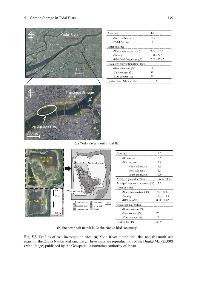
Fig. 5.3 Profiles of two investigation sites. (a) Yodo River mouth tidal flat, and (b) north salt
marsh in the Osaka Nanko bird sanctuary. These maps are reproductions of the Digital Map 25,000
(Map Image) published by the Geospatial Information Authority of Japan
5 Carbon Storage in Tidal Flats
(a) Yodo River mouth tidal flat
(b) the north salt marsh in Osaka Nanko bird sanctuary
1km
The Great Barrage
Investigation area
500 m
Yodo River
50 m
Subtidal zone
Intertidal zone
Supratidal zone
Green land
Upland
Reed zone
North salt marsh
West salt marsh
North Salt
marsh
West
Salt marsh
South Salt marsh
0 m
50 m
200 m
Area (ha)
19.3
-Green area
-Wetland area
-North salt marsh
-West salt marsh
-South salt marsh
6.5
12.8
4.6
1.4
3.8
Averaged ground level (m)
L.W.L. +0.72
Averaged exposure rate to air (%) 17.3
Water qualities
-Water temperature (ºC)
-Salinity
-DIN (mg-N/l)
7.5 – 30.6
13.2 – 30.0
0.11 – 0.62
Grain size distribution
-Gravel content (%)
-Sand content (%)
-Clay content (%)
18
70
12
Ignition loss (%)
6 - 9
Area (ha)
4.5
-Salt marsh area
-Tidal flat area
4.2
0.3
Water qualities
-Water temperature ( o C)
-Salinity
-Dissolved Oxygen (mg/l)
2.62 – 36.5
0 – 22.9
0.01 –17.42
Grain size distribution (tidal flat)
-Gravel content (%)
-Sand content (%)
-Clay content (%)
0
80
20
Ignition loss (%) (tidal flat)
6 - 13
Fig. 5.3 Profiles of two investigation sites. (a) Yodo River mouth tidal flat, and (b) north salt
marsh in the Osaka Nanko bird sanctuary. These maps are reproductions of the Digital Map 25,000
(Map Image) published by the Geospatial Information Authority of Japan
5 Carbon Storage in Tidal Flats