

134
5.3.1 Yodo River Mouth Tidal Flat
The Yodo River tidal flat and salt marsh are located about 8 km upstream from the
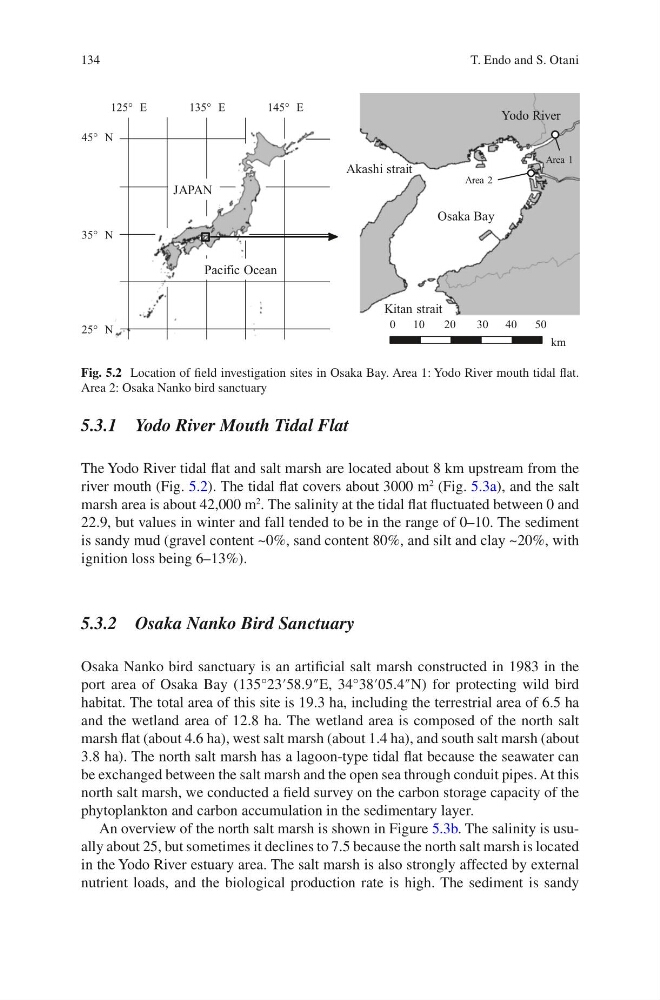
river mouth (Fig. 5.2). The tidal flat covers about 3000 m
2
(Fig. 5.3a), and the salt
marsh area is about 42,000 m
2
. The salinity at the tidal flat fluctuated between 0 and
22.9, but values in winter and fall tended to be in the range of 0–10. The sediment
is sandy mud (gravel content ~0%, sand content 80%, and silt and clay ~20%, with
ignition loss being 6–13%).
5.3.2 Osaka Nanko Bird Sanctuary
Osaka Nanko bird sanctuary is an artificial salt marsh constructed in 1983 in the
port area of Osaka Bay (135°23′58.9″E, 34°38′05.4″N) for protecting wild bird
habitat. The total area of this site is 19.3 ha, including the terrestrial area of 6.5 ha
and the wetland area of 12.8 ha. The wetland area is composed of the north salt
marsh flat (about 4.6 ha), west salt marsh (about 1.4 ha), and south salt marsh (about
3.8 ha). The north salt marsh has a lagoon-type tidal flat because the seawater can
be exchanged between the salt marsh and the open sea through conduit pipes. At this
north salt marsh, we conducted a field survey on the carbon storage capacity of the
phytoplankton and carbon accumulation in the sedimentary layer.
An overview of the north salt marsh is shown in Figure 5.3b. The salinity is usually about 25, but sometimes it declines to 7.5 because the north salt marsh is located
in the Yodo River estuary area. The salt marsh is also strongly affected by external
nutrient loads, and the biological production rate is high. The sediment is sandy
35° N
45° N
145° E
135° E
125° E
25° N
0
2 0
5 0
10
30 40
km
JAPAN
Pacific Ocean
Osaka Bay
Yodo River
Area 1
Area 2
Akashi strait
Kitan strait
Fig. 5.2 Location of field investigation sites in Osaka Bay. Area 1: Yodo River mouth tidal flat.
Area 2: Osaka Nanko bird sanctuary
T. Endo and S. Otani
5.3.1 Yodo River Mouth Tidal Flat
The Yodo River tidal flat and salt marsh are located about 8 km upstream from the
river mouth (Fig. 5.2). The tidal flat covers about 3000 m
2
(Fig. 5.3a), and the salt
marsh area is about 42,000 m
2
. The salinity at the tidal flat fluctuated between 0 and
22.9, but values in winter and fall tended to be in the range of 0–10. The sediment
is sandy mud (gravel content ~0%, sand content 80%, and silt and clay ~20%, with
ignition loss being 6–13%).
5.3.2 Osaka Nanko Bird Sanctuary
Osaka Nanko bird sanctuary is an artificial salt marsh constructed in 1983 in the
port area of Osaka Bay (135°23′58.9″E, 34°38′05.4″N) for protecting wild bird
habitat. The total area of this site is 19.3 ha, including the terrestrial area of 6.5 ha
and the wetland area of 12.8 ha. The wetland area is composed of the north salt
marsh flat (about 4.6 ha), west salt marsh (about 1.4 ha), and south salt marsh (about
3.8 ha). The north salt marsh has a lagoon-type tidal flat because the seawater can
be exchanged between the salt marsh and the open sea through conduit pipes. At this
north salt marsh, we conducted a field survey on the carbon storage capacity of the
phytoplankton and carbon accumulation in the sedimentary layer.
An overview of the north salt marsh is shown in Figure 5.3b. The salinity is usually about 25, but sometimes it declines to 7.5 because the north salt marsh is located
in the Yodo River estuary area. The salt marsh is also strongly affected by external
nutrient loads, and the biological production rate is high. The sediment is sandy
35° N
45° N
145° E
135° E
125° E
25° N
0
2 0
5 0
10
30 40
km
JAPAN
Pacific Ocean
Osaka Bay
Yodo River
Area 1
Area 2
Akashi strait
Kitan strait
Fig. 5.2 Location of field investigation sites in Osaka Bay. Area 1: Yodo River mouth tidal flat.
Area 2: Osaka Nanko bird sanctuary
T. Endo and S. Otani