

716
Chapter 14 Hydrocarbons and Coal
a
NIGER DELTA "/OUTCROPPING
. U. CRETACEOUS
b
SSW
MARINE
SHALES
o~------~--~-=~~
20
km
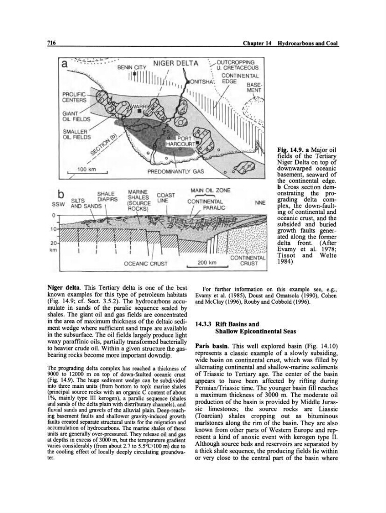
Niger delta. This Tertiary delta is one of the best
known examples for this type of petroleum habitats
(Fig. 14.9; cf. Sect. 3.5.2). The hydrocarbons aceumulate in sands of the paralic sequenee sealed by
shales. The giant oil and gas fields are coneentrated
in the area of maximum thickness of the deltaic sediment wedge where sufficient sand traps are available
in the subsurface. The oil fields largely produce light
waxy paraffinie oils, partially transformed bacterially
to heavier crnde oil. Within a given structure the gasbearing rocks become more important downdip.
The prograding delta eomplex has reaehed a thiekness of
9000 to 12000 m on top of down-faulted oceanie erust
(Fig. 14.9). The huge sediment wedge ean be subdivided
into three main units (from bottom to top): marine shales
(prineipal souree rocks with an organie C eontent of about
1%, mainly type III kerogen), a paralie sequenee (shales
and sands ofthe delta plain with distributary ehannels), and
fluvial sands and gravels of the alluvial plain. Deep-reaehing basement faults and shallower gravity-indueed growth
faults ereated separate struetural units for the migration and
aecumulation of hydroearbons. The marine shales of these
units are generally over-pressured. They release oil and gas
at depths in exeess of 3000 In, but the temperature gradient
varies eonsiderably (from about 2.7 to 5.5°C/100 m) due to
the eooling effeet of loeally deeply eireulating groundwater.
MAIN OlL ZONE
~
CONTINENTAL
PARALIC
200 km
NNE
Fig. 14.9. a Major oil
fields of the Tertiary
Niger Delta on top of
downwarped oeeanic
basement, seaward of
the continental edge.
b Cross seetion demonstrating the prograding delta eomplex, the down-faultmg of eontinental and
oeeanie ernst, and the
subsided and buried
growth faults generated along the former
delta front. (After
Evamy et al. 1978;
Tissot and Weite
1984)
For further information on this example see, e.g.,
Evamy et al. (1985), Doust and Ornatsola (1990), Cohen
and MeClay (1996), Rouby and Cobbold (1996).
14.3.3 Rift Basins and
Shallow Epicontinental Seas
Paris basin. This weil explored basin (Fig. 14.10)
represents a classic example of a slowly subsiding,
wide basin on eontinental ernst, which was filled by
altemating eontinental and shallow-marine sediments
of Triassie to Tertiary age. The center ofthe basin
appears to have been affected by rifting during
PermianlTriassic time. The younger basin fill reaches
a maximum thiekness of 3000 m. The moderate oil
production of the basin is provided by Middle Jurassie limestones; the souree rocks are Liassic
(Toareian) shales eropping out as bituminous
marlstones along the rim of the basin. They are also
known from other parts of Western Europe and represent a kind of anoxie event with kerogen type IL
Although souree beds and reservoirs are separated by
a thick shale sequence, the produeing fields lie within
or very close to the central part of the basin where