

3.2 Tidal Flats
119
CLiMATE
ENVIRONMENT
HUMID
TEMPERATE
SILICICLASTICS
HUMID, WARM
SllICICL. AND/ OR
CARBONATE
HUMID
TEMPERATE
MUD-DOMINA TED
SILIC lCLASTICS
ARID
WARM
CARBONA TIC OR
SlliCICLASTIC
/
IN PLACES : CARBO1TV"tLFnn- NATE ROCK,
CONTINENTAL
-t - - - SAL T MARSH.
\
~~~~1~~f;· ~
KARSTIFIEO _.,..
EOLlAN,
~GAL MARSH
FLUVIAL
\
I
SUPRAROOTS
STORM L. (SAND,
~~iI--'" BROKEN CRUSTS _ _
_
FlUVIAL
SANDS
OR ALGAL MATS)
SUPRALEYEE-DEP.
TIDAL
TIDAL
STOR'" lAYERS
- } __ (SAND. SHELlSI
INTERTIDAL
FLASER BEDS
ALG. MATS,
__ "'-_
MUD CRACKS
..
LENTICULAR
INTERLAMIN.
MUD
FLASER
& lENTICUlAR
BEOS
J __ _
GROVEI. SHELLS
TIDAL
MUD, BIOT.
1 _-/ ~
SHALLOW -
-
I
CHANNELS
I tc...~"""iL-LAMINATED SAND
MUDDY SAND, BIOT.
SUBT1DAL
I
I
I
MUD PEBBlES
I ~~
I
SAND. BIOTURB.
10 I=;~::oii!'.;--- MUD, WAYY
DEEP CHANNELS. m
SUBTIDAl
I
SAND RIDGES ,
TIDAL INlET
I
DEPOSITS
I
(EBB AND FlOODCOARSE SAND
(IN PLACES
OOltTIC)
- - " ' - -
- - { " -
I
SUBTIDAL
I
--1-- I
MUD WITH
SOME
PEBBLES,
SHElLS
LAGOON,
BAY,
ADJACENT
SEA
MUDDY
CHANNEL
FILL,
BIOTURBATED
I
I
LAGOONAL (OR
BAY) MUD . BIOTURBATED.
SAND LAYERS
OR : MASSIYE
REEF (BIOHERM
OR BIOSTROME)
I
I
I
I
TlDAL DELTA
I
SANDS)
I
I
CHANNEL lAG
(GRAYELLY SAND,
SHElL DEBRIS)
I
1 __ -
SHALLOW OPEN
SEA (INNER SHELF)
I
.. HYDRAULIC
REGIME
I
,
FINE SAND AND
MUDDY SAND,
BIOTURBATED
HIGH-ENERGY
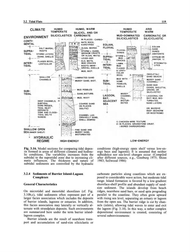
Fig. 3.16. Model sections for comparing tidal deposits formed in areas of different climates and hydraulic conditions. The variability increases from the
subtidal to the supratidal zone due to increasing climatic influences. The thickness and nature of
subtidal sediments are controlled by the hydraulic
3.2.4 Sediments of Barrier Island-Lagoon
Complexes
General Characteristics
On microtidal and mesotidal shorelines (cf. Fig.
3.1 Ob,c), tidal sediments often represent part of a
larger facies association which includes the deposits
of baITier islands, lagoons or estuaries. In addition,
this facies association may laterally or vertically alternate with strandplain deposits. Such environments
are summarized here under the term baITier islandlagoon complex.
BaITier islands are the result of nearshore transport and accumulation of sand-size siliciclastic or
1) CHICKEN-WIRE TEXTURE
2) IN PLACES : GRAINSTONE CRUST.
! BORED {HARDGROUND)
LOW-ENERGY
conditions (high-energy open shelf versus low-energy bays and lagoons). It is assumed that neither
subsidence nor sea-Ievel changes occur. (Compiled
after different sourees, e.g., Ginsburg 1975; Shinn
1983; Sellwood 1986)
carbonate particles along coastlines which are exposed to considerable wave action, but moderate tidal
range. Island formation is favored by a low-gradient
shoreface-shelf profile and abundant supply of sandsize sediment. The islands develop from beach
ridges, nearshore sand bars, or sand spits prograding
parallel to the coastline. They often grow upward
with rising sea level, separating an estuary or lagoon
from the open sea. The baITier ridge is cut by channels (inlets), allowing tidal waves to enter and exit
the lagoon (Fig. 3.18). In this way, a rather complex
depositional environment is created, consisting of
several subenvironments :
119
CLiMATE
ENVIRONMENT
HUMID
TEMPERATE
SILICICLASTICS
HUMID, WARM
SllICICL. AND/ OR
CARBONATE
HUMID
TEMPERATE
MUD-DOMINA TED
SILIC lCLASTICS
ARID
WARM
CARBONA TIC OR
SlliCICLASTIC
/
IN PLACES : CARBO1TV"tLFnn- NATE ROCK,
CONTINENTAL
-t - - - SAL T MARSH.
\
~~~~1~~f;· ~
KARSTIFIEO _.,..
EOLlAN,
~GAL MARSH
FLUVIAL
\
I
SUPRAROOTS
STORM L. (SAND,
~~iI--'" BROKEN CRUSTS _ _
_
FlUVIAL
SANDS
OR ALGAL MATS)
SUPRALEYEE-DEP.
TIDAL
TIDAL
STOR'" lAYERS
- } __ (SAND. SHELlSI
INTERTIDAL
FLASER BEDS
ALG. MATS,
__ "'-_
MUD CRACKS
..
LENTICULAR
INTERLAMIN.
MUD
FLASER
& lENTICUlAR
BEOS
J __ _
GROVEI. SHELLS
TIDAL
MUD, BIOT.
1 _-/ ~
SHALLOW -
-
I
CHANNELS
I tc...~"""iL-LAMINATED SAND
MUDDY SAND, BIOT.
SUBT1DAL
I
I
I
MUD PEBBlES
I ~~
I
SAND. BIOTURB.
10 I=;~::oii!'.;--- MUD, WAYY
DEEP CHANNELS. m
SUBTIDAl
I
SAND RIDGES ,
TIDAL INlET
I
DEPOSITS
I
(EBB AND FlOODCOARSE SAND
(IN PLACES
OOltTIC)
- - " ' - -
- - { " -
I
SUBTIDAL
I
--1-- I
MUD WITH
SOME
PEBBLES,
SHElLS
LAGOON,
BAY,
ADJACENT
SEA
MUDDY
CHANNEL
FILL,
BIOTURBATED
I
I
LAGOONAL (OR
BAY) MUD . BIOTURBATED.
SAND LAYERS
OR : MASSIYE
REEF (BIOHERM
OR BIOSTROME)
I
I
I
I
TlDAL DELTA
I
SANDS)
I
I
CHANNEL lAG
(GRAYELLY SAND,
SHElL DEBRIS)
I
1 __ -
SHALLOW OPEN
SEA (INNER SHELF)
I
.. HYDRAULIC
REGIME
I
,
FINE SAND AND
MUDDY SAND,
BIOTURBATED
HIGH-ENERGY
Fig. 3.16. Model sections for comparing tidal deposits formed in areas of different climates and hydraulic conditions. The variability increases from the
subtidal to the supratidal zone due to increasing climatic influences. The thickness and nature of
subtidal sediments are controlled by the hydraulic
3.2.4 Sediments of Barrier Island-Lagoon
Complexes
General Characteristics
On microtidal and mesotidal shorelines (cf. Fig.
3.1 Ob,c), tidal sediments often represent part of a
larger facies association which includes the deposits
of baITier islands, lagoons or estuaries. In addition,
this facies association may laterally or vertically alternate with strandplain deposits. Such environments
are summarized here under the term baITier islandlagoon complex.
BaITier islands are the result of nearshore transport and accumulation of sand-size siliciclastic or
1) CHICKEN-WIRE TEXTURE
2) IN PLACES : GRAINSTONE CRUST.
! BORED {HARDGROUND)
LOW-ENERGY
conditions (high-energy open shelf versus low-energy bays and lagoons). It is assumed that neither
subsidence nor sea-Ievel changes occur. (Compiled
after different sourees, e.g., Ginsburg 1975; Shinn
1983; Sellwood 1986)
carbonate particles along coastlines which are exposed to considerable wave action, but moderate tidal
range. Island formation is favored by a low-gradient
shoreface-shelf profile and abundant supply of sandsize sediment. The islands develop from beach
ridges, nearshore sand bars, or sand spits prograding
parallel to the coastline. They often grow upward
with rising sea level, separating an estuary or lagoon
from the open sea. The baITier ridge is cut by channels (inlets), allowing tidal waves to enter and exit
the lagoon (Fig. 3.18). In this way, a rather complex
depositional environment is created, consisting of
several subenvironments :