

6 Wavelet Analysis of SAR Images in the Marginal Ice Zone
115
formed with various scales to separate various textures or features. The Mexican-hat
wavelet is used as a band-pass filter to separate various scale processes and show their
relative location information. The two-dimensional Mexican-hat wavelet transform of
a SAR image for small-scale features is used with a threshold as an edge detector. A
binary image can then be produced in order to reduce the data volume. By tracking the
ice feature evolution from repeat satellite path and using the ocean-ice interaction
model (Liu et al. 1993), an ice velocity field has been derived for the study of sea ice
dynamics and processes.
6.3.1
Chukchi Sea Marginal Ice Zone
In the Chukchi Sea, a sequence of seven SAR images from September 27 and October
3 to October 18,1991, with 3-day intervals were studied for ice edge advance/retreat. Each
SAR image was 100 x 100 km in size and the pixel sizes were 100 m. The ice edge in each
SAR image was delineated using two-dimensional Mexican-hat wavelet transform as
an edge detector with a scale of 1.6 km, and the maximum intensity gradient lines above
a threshold (70%) were extracted from the images. The scale of 1.6 km was chosen to
resolve the curvature of the ice edge meanders. Thus, the mesoscale features such as ice
edge and the boundaries of eddies could be effectively delineated by such wavelet transforms. When the ice edge was not all well defined, the intensity gradient lines was found
to be piecemeal. The disconnected joints were then linked by straight lines.
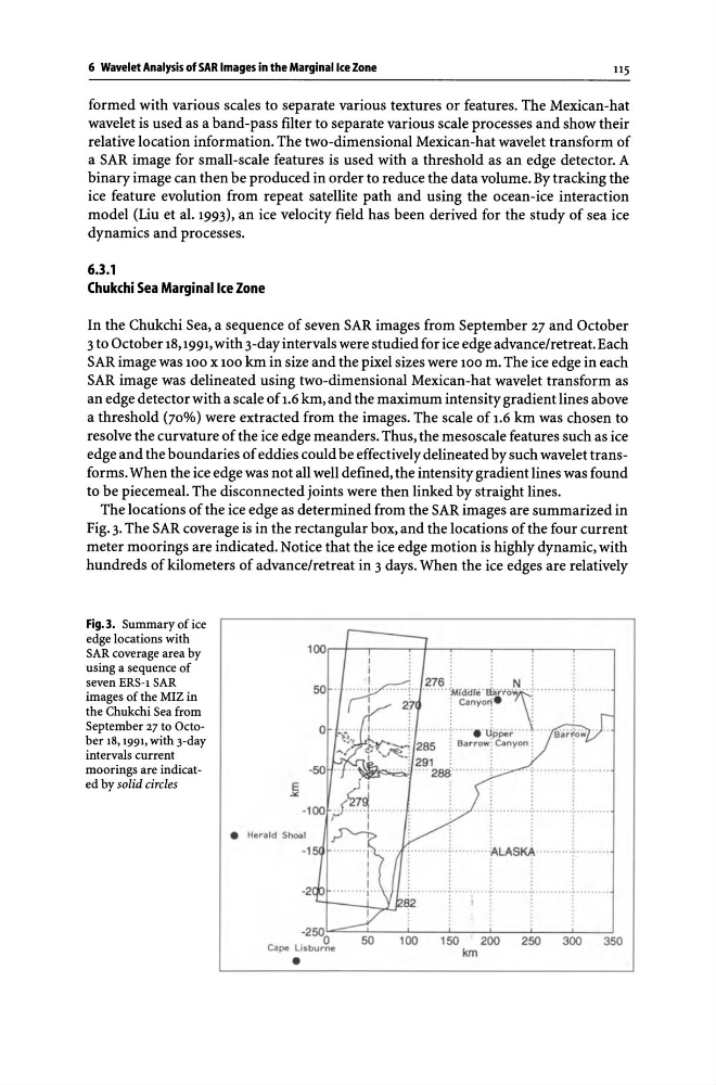
The locations of the ice edge as determined from the SAR images are summarized in
Fig. 3. The SAR coverage is in the rectangular box, and the locations of the four current
meter moorings are indicated. Notice that the ice edge motion is highly dynamic, with
hundreds of kilometers of advance/retreat in 3 days. When the ice edges are relatively
Fig.3. Summary of ice
edge locations with
SAR coverage area by
using a sequence of
seven ERS-1 SAR
images of the MIZ in
the Chukchi Sea from
September 27 to October 18, 1991, with 3-day
intervals current
moorings are indicated by solid circles
100 ~+-~--~-+--.----r---'r---~--50
o
•
Heradd S hoal
-1
-250 0
Cape lisburne
•
50
· kL:AS~··········~····"·· ·
.
.
.
I
;
100
150
200
250
300
350
km
115
formed with various scales to separate various textures or features. The Mexican-hat
wavelet is used as a band-pass filter to separate various scale processes and show their
relative location information. The two-dimensional Mexican-hat wavelet transform of
a SAR image for small-scale features is used with a threshold as an edge detector. A
binary image can then be produced in order to reduce the data volume. By tracking the
ice feature evolution from repeat satellite path and using the ocean-ice interaction
model (Liu et al. 1993), an ice velocity field has been derived for the study of sea ice
dynamics and processes.
6.3.1
Chukchi Sea Marginal Ice Zone
In the Chukchi Sea, a sequence of seven SAR images from September 27 and October
3 to October 18,1991, with 3-day intervals were studied for ice edge advance/retreat. Each
SAR image was 100 x 100 km in size and the pixel sizes were 100 m. The ice edge in each
SAR image was delineated using two-dimensional Mexican-hat wavelet transform as
an edge detector with a scale of 1.6 km, and the maximum intensity gradient lines above
a threshold (70%) were extracted from the images. The scale of 1.6 km was chosen to
resolve the curvature of the ice edge meanders. Thus, the mesoscale features such as ice
edge and the boundaries of eddies could be effectively delineated by such wavelet transforms. When the ice edge was not all well defined, the intensity gradient lines was found
to be piecemeal. The disconnected joints were then linked by straight lines.
The locations of the ice edge as determined from the SAR images are summarized in
Fig. 3. The SAR coverage is in the rectangular box, and the locations of the four current
meter moorings are indicated. Notice that the ice edge motion is highly dynamic, with
hundreds of kilometers of advance/retreat in 3 days. When the ice edges are relatively
Fig.3. Summary of ice
edge locations with
SAR coverage area by
using a sequence of
seven ERS-1 SAR
images of the MIZ in
the Chukchi Sea from
September 27 to October 18, 1991, with 3-day
intervals current
moorings are indicated by solid circles
100 ~+-~--~-+--.----r---'r---~--50
o
•
Heradd S hoal
-1
-250 0
Cape lisburne
•
50
· kL:AS~··········~····"·· ·
.
.
.
I
;
100
150
200
250
300
350
km