

Bathymetry and Structural Setting
The 1999 bathymetric studies covered an area of about 9,500 km
2 . From the
interpretation of bottom reflectivity (side scan sonar imagery) and the Simrad EM
12 multichannel bathymetry studies in the Pitcairn region, it was thought that
submarine hotspot activity extends over an area of about 7022 km
2 (Hekinian et al.
2003). The most prominent feature of the Pitcairn hotspot is the large amount of
volcanic cones. There is a total of about ninety volcanic cones and most of them
are less than 500 m in height and less than 2 km in diameter. They have erupted a
total of about 47 km
3 of volcanic rocks.
The sea floor forming the hotspot lies at 3750 m depth and covers a surface of
150 km in diameter. The floor surrounding the Pitcairn hotspot, which formed part
of the ancient Farallon plate, is part of the older crust in the Pacific Ocean,
estimated to be at about 4500 m depth (Parsons and Slater 1977; Crough 1978).
Hence, all the recent volcanoes built from hotspot activity are above a depth of
3750 m. Thus, the recent volcanic activity within the Pitcairn hotspot region is
limited to an area above the 3,700 m bathymetric contour line, where ancient
crustal orientations are covered by more recent lava flows with large ([1000 m
high) and small (\500 m high) volcanic edifices. Nevertheless, relics of ancient
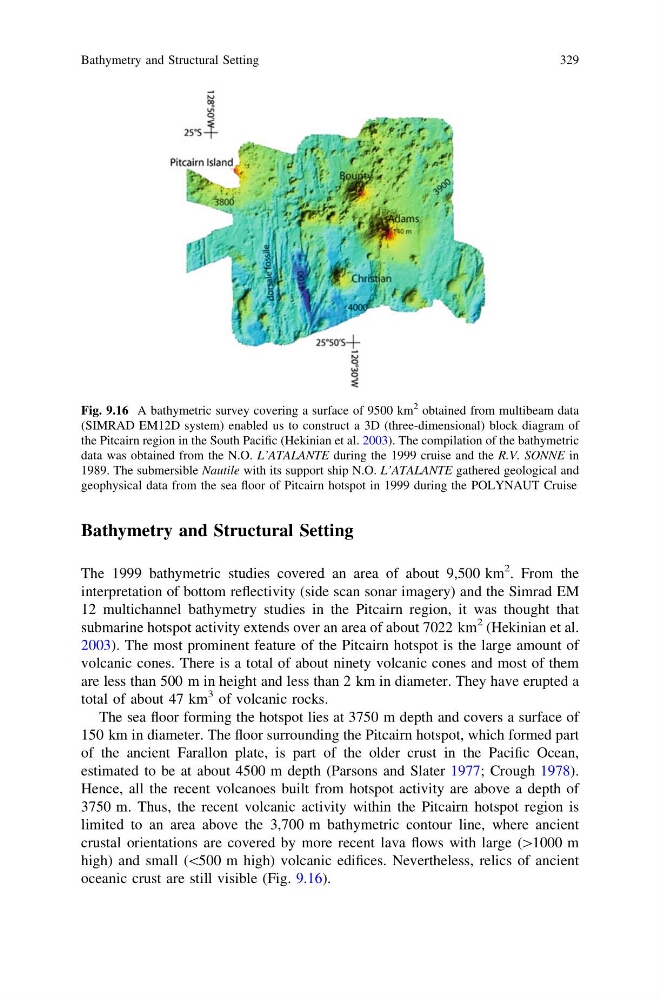
oceanic crust are still visible (Fig. 9.16).
Fig. 9.16 A bathymetric survey covering a surface of 9500 km
2 obtained from multibeam data
(SIMRAD EM12D system) enabled us to construct a 3D (three-dimensional) block diagram of
the Pitcairn region in the South Pacific (Hekinian et al. 2003). The compilation of the bathymetric
data was obtained from the N.O. L’ATALANTE during the 1999 cruise and the R.V. SONNE in
1989. The submersible Nautile with its support ship N.O. L’ATALANTE gathered geological and
geophysical data from the sea floor of Pitcairn hotspot in 1999 during the POLYNAUT Cruise
Bathymetry and Structural Setting
329
The 1999 bathymetric studies covered an area of about 9,500 km
2 . From the
interpretation of bottom reflectivity (side scan sonar imagery) and the Simrad EM
12 multichannel bathymetry studies in the Pitcairn region, it was thought that
submarine hotspot activity extends over an area of about 7022 km
2 (Hekinian et al.
2003). The most prominent feature of the Pitcairn hotspot is the large amount of
volcanic cones. There is a total of about ninety volcanic cones and most of them
are less than 500 m in height and less than 2 km in diameter. They have erupted a
total of about 47 km
3 of volcanic rocks.
The sea floor forming the hotspot lies at 3750 m depth and covers a surface of
150 km in diameter. The floor surrounding the Pitcairn hotspot, which formed part
of the ancient Farallon plate, is part of the older crust in the Pacific Ocean,
estimated to be at about 4500 m depth (Parsons and Slater 1977; Crough 1978).
Hence, all the recent volcanoes built from hotspot activity are above a depth of
3750 m. Thus, the recent volcanic activity within the Pitcairn hotspot region is
limited to an area above the 3,700 m bathymetric contour line, where ancient
crustal orientations are covered by more recent lava flows with large ([1000 m
high) and small (\500 m high) volcanic edifices. Nevertheless, relics of ancient
oceanic crust are still visible (Fig. 9.16).
Fig. 9.16 A bathymetric survey covering a surface of 9500 km
2 obtained from multibeam data
(SIMRAD EM12D system) enabled us to construct a 3D (three-dimensional) block diagram of
the Pitcairn region in the South Pacific (Hekinian et al. 2003). The compilation of the bathymetric
data was obtained from the N.O. L’ATALANTE during the 1999 cruise and the R.V. SONNE in
1989. The submersible Nautile with its support ship N.O. L’ATALANTE gathered geological and
geophysical data from the sea floor of Pitcairn hotspot in 1999 during the POLYNAUT Cruise
Bathymetry and Structural Setting
329