

4 Discoveries About Tropical Cyclones Provided by Microwave Remote Sensing
61
10/20/09 1800Z 22W LUPIT
10/21/09 1200Z 22W LUPIT
10/20/09 2033Z F - 17 VAPOR
10/21/09 1425Z TRMM 85PCT
10/20/09 2030Z MTSAT IR
10/21/09 1430Z MTSAT IR
– Precipitable Water (mm)
–
– 85 GHz PCT (Kelvin) –
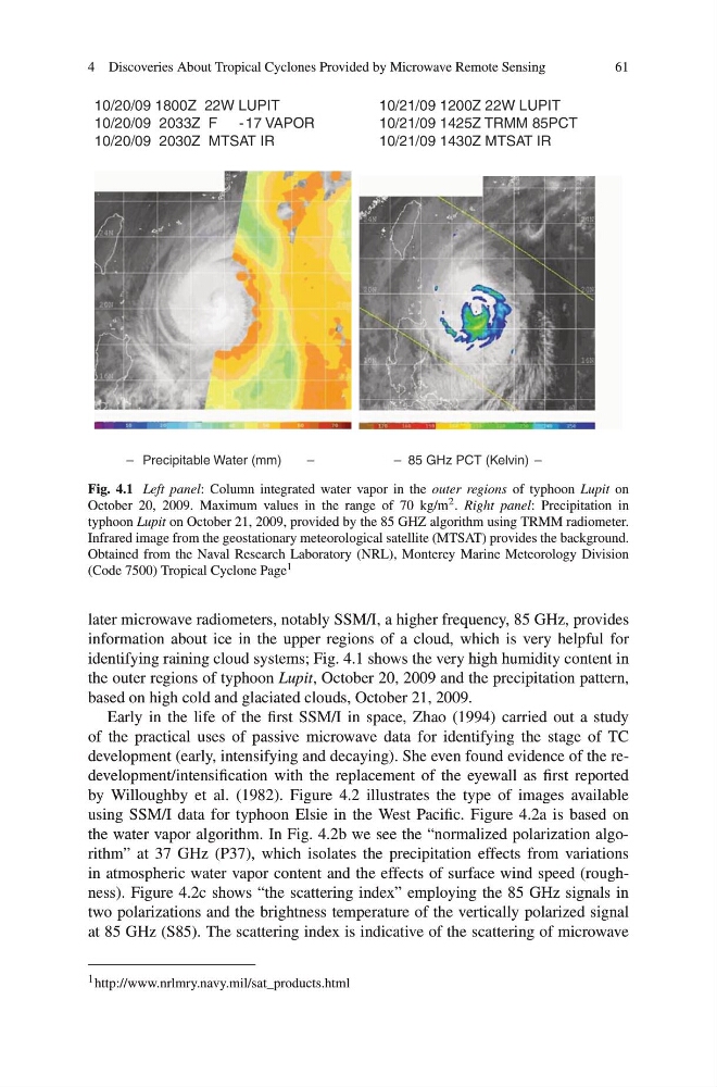
Fig. 4.1 Left panel: Column integrated water vapor in the outer regions of typhoon Lupit on
October 20, 2009. Maximum values in the range of 70 kg/m 2 . Right panel: Precipitation in
typhoon Lupit on October 21, 2009, provided by the 85 GHZ algorithm using TRMM radiometer.
Infrared image from the geostationary meteorological satellite (MTSAT) provides the background.
Obtained from the Naval Research Laboratory (NRL), Monterey Marine Meteorology Division
(Code 7500) Tropical Cyclone Page 1
later microwave radiometers, notably SSM/I, a higher frequency, 85 GHz, provides
information about ice in the upper regions of a cloud, which is very helpful for
identifying raining cloud systems; Fig. 4.1 shows the very high humidity content in
the outer regions of typhoon Lupit, October 20, 2009 and the precipitation pattern,
based on high cold and glaciated clouds, October 21, 2009.
Early in the life of the first SSM/I in space, Zhao (1994) carried out a study
of the practical uses of passive microwave data for identifying the stage of TC
development (early, intensifying and decaying). She even found evidence of the redevelopment/intensification with the replacement of the eyewall as first reported
by Willoughby et al. (1982). Figure 4.2 illustrates the type of images available
using SSM/I data for typhoon Elsie in the West Pacific. Figure 4.2a is based on
the water vapor algorithm. In Fig. 4.2b we see the “normalized polarization algorithm” at 37 GHz (P37), which isolates the precipitation effects from variations
in atmospheric water vapor content and the effects of surface wind speed (roughness). Figure 4.2c shows “the scattering index” employing the 85 GHz signals in
two polarizations and the brightness temperature of the vertically polarized signal
at 85 GHz (S85). The scattering index is indicative of the scattering of microwave
1 http://www.nrlmry.navy.mil/sat_products.html
61
10/20/09 1800Z 22W LUPIT
10/21/09 1200Z 22W LUPIT
10/20/09 2033Z F - 17 VAPOR
10/21/09 1425Z TRMM 85PCT
10/20/09 2030Z MTSAT IR
10/21/09 1430Z MTSAT IR
– Precipitable Water (mm)
–
– 85 GHz PCT (Kelvin) –
Fig. 4.1 Left panel: Column integrated water vapor in the outer regions of typhoon Lupit on
October 20, 2009. Maximum values in the range of 70 kg/m 2 . Right panel: Precipitation in
typhoon Lupit on October 21, 2009, provided by the 85 GHZ algorithm using TRMM radiometer.
Infrared image from the geostationary meteorological satellite (MTSAT) provides the background.
Obtained from the Naval Research Laboratory (NRL), Monterey Marine Meteorology Division
(Code 7500) Tropical Cyclone Page 1
later microwave radiometers, notably SSM/I, a higher frequency, 85 GHz, provides
information about ice in the upper regions of a cloud, which is very helpful for
identifying raining cloud systems; Fig. 4.1 shows the very high humidity content in
the outer regions of typhoon Lupit, October 20, 2009 and the precipitation pattern,
based on high cold and glaciated clouds, October 21, 2009.
Early in the life of the first SSM/I in space, Zhao (1994) carried out a study
of the practical uses of passive microwave data for identifying the stage of TC
development (early, intensifying and decaying). She even found evidence of the redevelopment/intensification with the replacement of the eyewall as first reported
by Willoughby et al. (1982). Figure 4.2 illustrates the type of images available
using SSM/I data for typhoon Elsie in the West Pacific. Figure 4.2a is based on
the water vapor algorithm. In Fig. 4.2b we see the “normalized polarization algorithm” at 37 GHz (P37), which isolates the precipitation effects from variations
in atmospheric water vapor content and the effects of surface wind speed (roughness). Figure 4.2c shows “the scattering index” employing the 85 GHz signals in
two polarizations and the brightness temperature of the vertically polarized signal
at 85 GHz (S85). The scattering index is indicative of the scattering of microwave
1 http://www.nrlmry.navy.mil/sat_products.html