

60
K.B. Katsaros
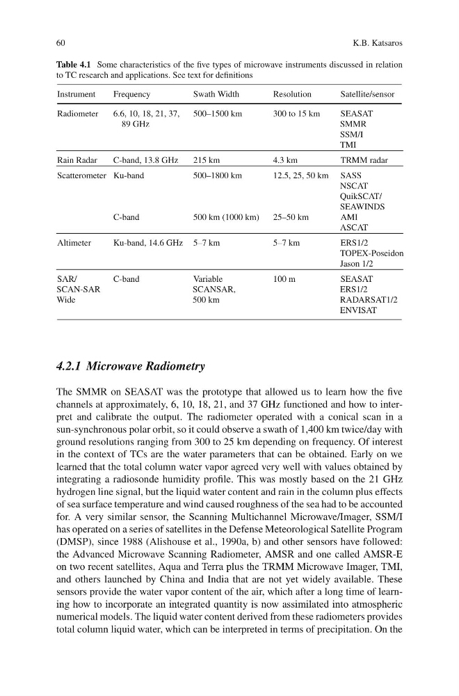
Table 4.1 Some characteristics of the five types of microwave instruments discussed in relation
to TC research and applications. See text for definitions
Instrument
Frequency
Swath Width
Resolution
Satellite/sensor
Radiometer
6.6, 10, 18, 21, 37,
89 GHz
500–1500 km
300 to 15 km
SEASAT
SMMR
SSM/I
TMI
Rain Radar
C-band, 13.8 GHz
215 km
4.3 km
TRMM radar
Scatterometer Ku-band
500–1800 km
12.5, 25, 50 km SASS
NSCAT
QuikSCAT/
SEAWINDS
C-band
500 km (1000 km)
25–50 km
AMI
ASCAT
Altimeter
Ku-band, 14.6 GHz 5–7 km
5–7 km
ERS1/2
TOPEX-Poseidon
Jason 1/2
SAR/
SCAN-SAR
Wide
C-band
Variable
SCANSAR,
500 km
100 m
SEASAT
ERS1/2
RADARSAT1/2
ENVISAT
4.2.1 Microwave Radiometry
The SMMR on SEASAT was the prototype that allowed us to learn how the five
channels at approximately, 6, 10, 18, 21, and 37 GHz functioned and how to interpret and calibrate the output. The radiometer operated with a conical scan in a
sun-synchronous polar orbit, so it could observe a swath of 1,400 km twice/day with
ground resolutions ranging from 300 to 25 km depending on frequency. Of interest
in the context of TCs are the water parameters that can be obtained. Early on we
learned that the total column water vapor agreed very well with values obtained by
integrating a radiosonde humidity profile. This was mostly based on the 21 GHz
hydrogen line signal, but the liquid water content and rain in the column plus effects
of sea surface temperature and wind caused roughness of the sea had to be accounted
for. A very similar sensor, the Scanning Multichannel Microwave/Imager, SSM/I
has operated on a series of satellites in the Defense Meteorological Satellite Program
(DMSP), since 1988 (Alishouse et al., 1990a, b) and other sensors have followed:
the Advanced Microwave Scanning Radiometer, AMSR and one called AMSR-E
on two recent satellites, Aqua and Terra plus the TRMM Microwave Imager, TMI,
and others launched by China and India that are not yet widely available. These
sensors provide the water vapor content of the air, which after a long time of learning how to incorporate an integrated quantity is now assimilated into atmospheric
numerical models. The liquid water content derived from these radiometers provides
total column liquid water, which can be interpreted in terms of precipitation. On the
K.B. Katsaros
Table 4.1 Some characteristics of the five types of microwave instruments discussed in relation
to TC research and applications. See text for definitions
Instrument
Frequency
Swath Width
Resolution
Satellite/sensor
Radiometer
6.6, 10, 18, 21, 37,
89 GHz
500–1500 km
300 to 15 km
SEASAT
SMMR
SSM/I
TMI
Rain Radar
C-band, 13.8 GHz
215 km
4.3 km
TRMM radar
Scatterometer Ku-band
500–1800 km
12.5, 25, 50 km SASS
NSCAT
QuikSCAT/
SEAWINDS
C-band
500 km (1000 km)
25–50 km
AMI
ASCAT
Altimeter
Ku-band, 14.6 GHz 5–7 km
5–7 km
ERS1/2
TOPEX-Poseidon
Jason 1/2
SAR/
SCAN-SAR
Wide
C-band
Variable
SCANSAR,
500 km
100 m
SEASAT
ERS1/2
RADARSAT1/2
ENVISAT
4.2.1 Microwave Radiometry
The SMMR on SEASAT was the prototype that allowed us to learn how the five
channels at approximately, 6, 10, 18, 21, and 37 GHz functioned and how to interpret and calibrate the output. The radiometer operated with a conical scan in a
sun-synchronous polar orbit, so it could observe a swath of 1,400 km twice/day with
ground resolutions ranging from 300 to 25 km depending on frequency. Of interest
in the context of TCs are the water parameters that can be obtained. Early on we
learned that the total column water vapor agreed very well with values obtained by
integrating a radiosonde humidity profile. This was mostly based on the 21 GHz
hydrogen line signal, but the liquid water content and rain in the column plus effects
of sea surface temperature and wind caused roughness of the sea had to be accounted
for. A very similar sensor, the Scanning Multichannel Microwave/Imager, SSM/I
has operated on a series of satellites in the Defense Meteorological Satellite Program
(DMSP), since 1988 (Alishouse et al., 1990a, b) and other sensors have followed:
the Advanced Microwave Scanning Radiometer, AMSR and one called AMSR-E
on two recent satellites, Aqua and Terra plus the TRMM Microwave Imager, TMI,
and others launched by China and India that are not yet widely available. These
sensors provide the water vapor content of the air, which after a long time of learning how to incorporate an integrated quantity is now assimilated into atmospheric
numerical models. The liquid water content derived from these radiometers provides
total column liquid water, which can be interpreted in terms of precipitation. On the