

18 Field Radiometry and Ocean Color Remote Sensing
313
systems generally provide the capability of measuring L u (z,λ) and E d (z,λ) at two or
more depths (typically between 1 and 10 m) in addition to the above-water downward irradiance E d (0 + ,λ). By neglecting the effects of system tilt, the accuracy of
radiometric products determined with buoys is a function of the discrete depths
selected for the radiometers, the acquisition rate and the logging interval (Zibordi
et al., 2009a).
18.3.4 Imaging Systems
The radiance distribution (angular variation of the radiance field) is important to
investigate the anisotropy of light in natural waters (Voss and Morel, 2005). These
investigations were performed over several decades by designing and applying systems based on single field-of-view radiometers (Jerlov and Fukuda, 1960; Tyler,
1960; Aas and Hojerslev, 1999). With these radiometers, successive measurements
over various directions were required to map the in-water light field distribution. A
significant advance in measuring radiance distribution was marked by the development of an underwater camera equipped with a fisheye lens and a photopic filter
(Smith et al., 1969). This measurement concept was later revisited and applied to
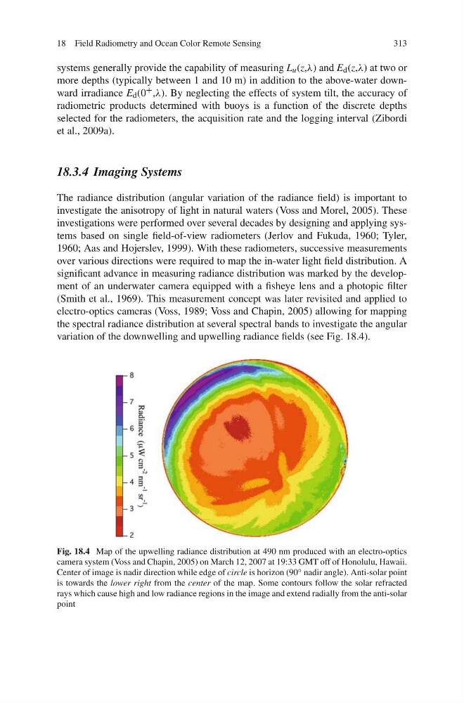
electro-optics cameras (Voss, 1989; Voss and Chapin, 2005) allowing for mapping
the spectral radiance distribution at several spectral bands to investigate the angular
variation of the downwelling and upwelling radiance fields (see Fig. 18.4).
Fig. 18.4 Map of the upwelling radiance distribution at 490 nm produced with an electro-optics
camera system (Voss and Chapin, 2005) on March 12, 2007 at 19:33 GMT off of Honolulu, Hawaii.
Center of image is nadir direction while edge of circle is horizon (90 ◦ nadir angle). Anti-solar point
is towards the lower right from the center of the map. Some contours follow the solar refracted
rays which cause high and low radiance regions in the image and extend radially from the anti-solar
point
313
systems generally provide the capability of measuring L u (z,λ) and E d (z,λ) at two or
more depths (typically between 1 and 10 m) in addition to the above-water downward irradiance E d (0 + ,λ). By neglecting the effects of system tilt, the accuracy of
radiometric products determined with buoys is a function of the discrete depths
selected for the radiometers, the acquisition rate and the logging interval (Zibordi
et al., 2009a).
18.3.4 Imaging Systems
The radiance distribution (angular variation of the radiance field) is important to
investigate the anisotropy of light in natural waters (Voss and Morel, 2005). These
investigations were performed over several decades by designing and applying systems based on single field-of-view radiometers (Jerlov and Fukuda, 1960; Tyler,
1960; Aas and Hojerslev, 1999). With these radiometers, successive measurements
over various directions were required to map the in-water light field distribution. A
significant advance in measuring radiance distribution was marked by the development of an underwater camera equipped with a fisheye lens and a photopic filter
(Smith et al., 1969). This measurement concept was later revisited and applied to
electro-optics cameras (Voss, 1989; Voss and Chapin, 2005) allowing for mapping
the spectral radiance distribution at several spectral bands to investigate the angular
variation of the downwelling and upwelling radiance fields (see Fig. 18.4).
Fig. 18.4 Map of the upwelling radiance distribution at 490 nm produced with an electro-optics
camera system (Voss and Chapin, 2005) on March 12, 2007 at 19:33 GMT off of Honolulu, Hawaii.
Center of image is nadir direction while edge of circle is horizon (90 ◦ nadir angle). Anti-solar point
is towards the lower right from the center of the map. Some contours follow the solar refracted
rays which cause high and low radiance regions in the image and extend radially from the anti-solar
point