

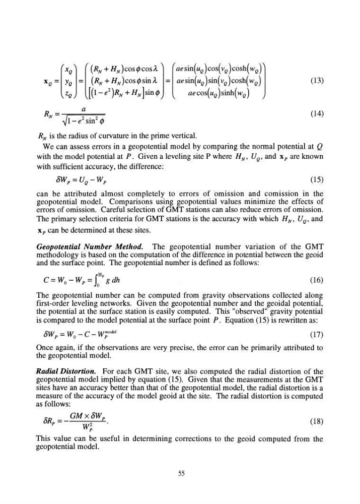
(13)
a
RN = ---;==~===::==
~1- e 2 sin 2 l /J
(14)
RN is the radius of curvature in the prime vertical.
We can assess errors in a geopotential model by comparing the normal potential at Q
with the model potential at P. Given a leveling site P where H N , U Q , and xp are known
with sufficient accuracy, the difference:
8Wp = U Q - Wp
(15)
can be attributed almost completely to errors of omission and comission in the
geopotential model. Comparisons using geopotential values minimize the effects of
errors of omission. Careful selection of GMT stations can also reduce errors of omission.
The primary selection criteria for GMT stations is the accuracy with which H N' U Q' and
x p can be determined at these sites.
Geopotential Number Method. The geopotential number vanatIOn of the GMT
methodology is based on the computation of the difference in potential between the geoid
and the surface point. The geopotential number is defined as follows:
rHp
C=Wo-Wp= Jo gdh
(16)
The geopotential number can be computed from gravity observations collected along
first-order leveling networks. Given the geopotential number and the geoidal potential,
the potential at the surface station is easily computed. This "observed" gravity potential
is compared to the model potential at the surface point P. Equation (15) is rewritten as:
8Wp = Wo - C - W;ode/
(17)
Once again, if the observations are very precise, the error can be primarily attributed to
the geopotential model.
Radial Distortion. For each GMT site, we also computed the radial distortion of the
geopotential model implied by equation (15). Given that the measurements at the GMT
sites have an accuracy better than that of the geopotential model, the radial distortion is a
measure of the accuracy of the model geoid at the site. The radial distortion is computed
as follows:
8R =_ GMx8Wp
p
W2 p
(18)
This value can be useful in determining corrections to the geoid computed from the
geopotential model.
55
a
RN = ---;==~===::==
~1- e 2 sin 2 l /J
(14)
RN is the radius of curvature in the prime vertical.
We can assess errors in a geopotential model by comparing the normal potential at Q
with the model potential at P. Given a leveling site P where H N , U Q , and xp are known
with sufficient accuracy, the difference:
8Wp = U Q - Wp
(15)
can be attributed almost completely to errors of omission and comission in the
geopotential model. Comparisons using geopotential values minimize the effects of
errors of omission. Careful selection of GMT stations can also reduce errors of omission.
The primary selection criteria for GMT stations is the accuracy with which H N' U Q' and
x p can be determined at these sites.
Geopotential Number Method. The geopotential number vanatIOn of the GMT
methodology is based on the computation of the difference in potential between the geoid
and the surface point. The geopotential number is defined as follows:
rHp
C=Wo-Wp= Jo gdh
(16)
The geopotential number can be computed from gravity observations collected along
first-order leveling networks. Given the geopotential number and the geoidal potential,
the potential at the surface station is easily computed. This "observed" gravity potential
is compared to the model potential at the surface point P. Equation (15) is rewritten as:
8Wp = Wo - C - W;ode/
(17)
Once again, if the observations are very precise, the error can be primarily attributed to
the geopotential model.
Radial Distortion. For each GMT site, we also computed the radial distortion of the
geopotential model implied by equation (15). Given that the measurements at the GMT
sites have an accuracy better than that of the geopotential model, the radial distortion is a
measure of the accuracy of the model geoid at the site. The radial distortion is computed
as follows:
8R =_ GMx8Wp
p
W2 p
(18)
This value can be useful in determining corrections to the geoid computed from the
geopotential model.
55