

APPLICATION TO THE OSU91A GEOPOTENTIAL MODEL
The authors have performed the GMT computations using the OSU91A (Rapp, et al.,
1991) spherical harmonic geopotential model to degree and order 360. Initial tests were
made for leveling stations in the Czech Republic and Slovakia and for satellite laser
ranging stations around the world. The OSU model was selected as one of the most
current global geopotential models.
Leveling Stations. The first set of results are for leveling stations in the Czech Republic
and Slovakia. Thirty-eight sites were selected for which precise geocentric positions and
normal heights have been measured. The geocentric positions were determined from
GPS observations and referenced to the ITRF93 reference frame. These data make it
possible to use the GMT methodology to assess the accuracy of the geopotential model
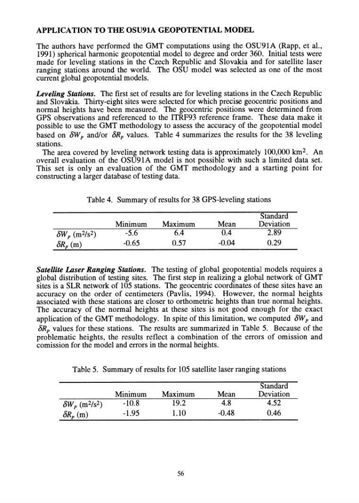
based on 8Wp and/or 8Rp values. Table 4 summarizes the results for the 38 leveling
stations.
The area covered by leveling network testing data is approximately 100,000 km 2 . An
overall evaluation of the OSU91A model is not possible with such a limited data set.
This set is only an evaluation of the GMT methodology and a starting point for
constructing a larger database of testing data.
Table 4. Summary of results for 38 GPS-Ieveling stations
8W p (m2/s2)
8Rp (m)
Minimum
-5.6
-0.65
Maximum
6.4
0.57
Mean
0.4
-0.04
Standard
Deviation
2.89
0.29
Satellite Laser Ranging Stations. The testing of global geopotential models requires a
global distribution of testing sites. The first step in realizing a global network of GMT
sites is a SLR network of 105 stations. The geocentric coordinates of these sites have an
accuracy on the order of centimeters (Pavlis, 1994). However, the normal heights
associated with these stations are closer to orthometric heights than true normal heights.
The accuracy of the normal heights at these sites is not good enough for the exact
application of the GMT methodology. In spite of this limitation, we computed 8Wp and
8Rp values for these stations. The results are summarized in Table 5. Because of the
problematic heights, the results reflect a combination of the errors of omission and
comission for the model and errors in the normal heights.
Table 5. Summary of results for 105 satellite laser ranging stations
Minimum
-10.8
-1.95
Maximum
19.2
1.10
56
Mean
4.8
-0.48
Standard
Deviation
4.52
0.46
The authors have performed the GMT computations using the OSU91A (Rapp, et al.,
1991) spherical harmonic geopotential model to degree and order 360. Initial tests were
made for leveling stations in the Czech Republic and Slovakia and for satellite laser
ranging stations around the world. The OSU model was selected as one of the most
current global geopotential models.
Leveling Stations. The first set of results are for leveling stations in the Czech Republic
and Slovakia. Thirty-eight sites were selected for which precise geocentric positions and
normal heights have been measured. The geocentric positions were determined from
GPS observations and referenced to the ITRF93 reference frame. These data make it
possible to use the GMT methodology to assess the accuracy of the geopotential model
based on 8Wp and/or 8Rp values. Table 4 summarizes the results for the 38 leveling
stations.
The area covered by leveling network testing data is approximately 100,000 km 2 . An
overall evaluation of the OSU91A model is not possible with such a limited data set.
This set is only an evaluation of the GMT methodology and a starting point for
constructing a larger database of testing data.
Table 4. Summary of results for 38 GPS-Ieveling stations
8W p (m2/s2)
8Rp (m)
Minimum
-5.6
-0.65
Maximum
6.4
0.57
Mean
0.4
-0.04
Standard
Deviation
2.89
0.29
Satellite Laser Ranging Stations. The testing of global geopotential models requires a
global distribution of testing sites. The first step in realizing a global network of GMT
sites is a SLR network of 105 stations. The geocentric coordinates of these sites have an
accuracy on the order of centimeters (Pavlis, 1994). However, the normal heights
associated with these stations are closer to orthometric heights than true normal heights.
The accuracy of the normal heights at these sites is not good enough for the exact
application of the GMT methodology. In spite of this limitation, we computed 8Wp and
8Rp values for these stations. The results are summarized in Table 5. Because of the
problematic heights, the results reflect a combination of the errors of omission and
comission for the model and errors in the normal heights.
Table 5. Summary of results for 105 satellite laser ranging stations
Minimum
-10.8
-1.95
Maximum
19.2
1.10
56
Mean
4.8
-0.48
Standard
Deviation
4.52
0.46