

Rossak et al.: Clay Mineral Distribution in Surface Sediments of the Lavtev Sea
589
Mesozoic, mostly clastic sediments are widespread in the western foreland basin of the
Werchojansk-Fold-Zone and north of the Siberian Platform in the lenissej-Khatanga-Basin. On
the Siberian platform basement crops out in the Aldan-shield drained by the Lena river and in
the Anabar-shield drained by the Anabar river (Dolginow and Kropatschjow, 1994; Nalivkin et
aI., 1965).
78 N
n
76
75
74
73
72
71
105 E
110
115
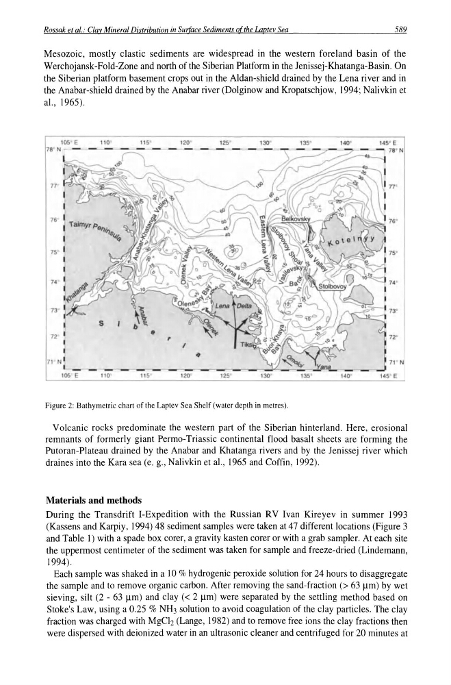
Figure 2: Bathymetric chart of the Laplev Sea Shelf (water depth in metres).
Volcanic rocks predominate the western part of the Siberian hinterland. Here, erosional
remnants of formerly giant Permo-Triassic continental flood basalt sheets are forming the
Putoran-Plateau drained by the Anabar and Khatanga rivers and by the Jenissej river which
draines into the Kara sea (e. g., Nalivkin et aI., 1965 and Coffin, 1992).
Materials and methods
During the Transdrift I-Expedition with the Russian RV Ivan Kireyev in summer 1993
(Kassens and Karpiy, 1994) 48 sediment samples were taken at 47 different locations (Figure 3
and Table 1) with a spade box corer, a gravity kasten corer or with a grab sampler. At each site
the uppermost centimeter of the sediment was taken for sample and freeze-dried (Lindemann,
1994).
Each sample was shaked in a 10 % hydrogenic peroxide solution for 24 hours to disaggregate
the sample and to remove organic carbon. After removing the sand-fraction (> 63 11m) by wet
sieving, silt (2 - 63 11m) and clay « 2 11m) were separated by the settling method based on
Stoke's Law, using a 0.25 % NH3 solution to avoid coagulation of the clay particles. The clay
fraction was charged with MgCI2 (Lange, 1982) and to remove free ions the clay fractions then
were dispersed with deionized water in an ultrasonic cleaner and centrifuged for 20 minutes at
589
Mesozoic, mostly clastic sediments are widespread in the western foreland basin of the
Werchojansk-Fold-Zone and north of the Siberian Platform in the lenissej-Khatanga-Basin. On
the Siberian platform basement crops out in the Aldan-shield drained by the Lena river and in
the Anabar-shield drained by the Anabar river (Dolginow and Kropatschjow, 1994; Nalivkin et
aI., 1965).
78 N
n
76
75
74
73
72
71
105 E
110
115
Figure 2: Bathymetric chart of the Laplev Sea Shelf (water depth in metres).
Volcanic rocks predominate the western part of the Siberian hinterland. Here, erosional
remnants of formerly giant Permo-Triassic continental flood basalt sheets are forming the
Putoran-Plateau drained by the Anabar and Khatanga rivers and by the Jenissej river which
draines into the Kara sea (e. g., Nalivkin et aI., 1965 and Coffin, 1992).
Materials and methods
During the Transdrift I-Expedition with the Russian RV Ivan Kireyev in summer 1993
(Kassens and Karpiy, 1994) 48 sediment samples were taken at 47 different locations (Figure 3
and Table 1) with a spade box corer, a gravity kasten corer or with a grab sampler. At each site
the uppermost centimeter of the sediment was taken for sample and freeze-dried (Lindemann,
1994).
Each sample was shaked in a 10 % hydrogenic peroxide solution for 24 hours to disaggregate
the sample and to remove organic carbon. After removing the sand-fraction (> 63 11m) by wet
sieving, silt (2 - 63 11m) and clay « 2 11m) were separated by the settling method based on
Stoke's Law, using a 0.25 % NH3 solution to avoid coagulation of the clay particles. The clay
fraction was charged with MgCI2 (Lange, 1982) and to remove free ions the clay fractions then
were dispersed with deionized water in an ultrasonic cleaner and centrifuged for 20 minutes at