

Are: The Role of Coastal Retreat for Sedimentation ill the Laptev Sea
293
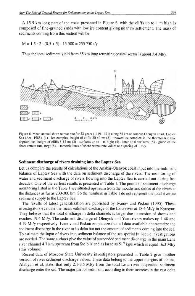
A 15.5 km long part of the coast presented in Figure 6, with the cliffs up to I m high is
composed of fine-grained sands with low ice content giving no thaw settlement. The mass of
sediments coming from this section will be
M = 1.5 . 2 . (0.5 + 5) . 15 500 = 255 750 t/y
Thus the total sediment yield from 85 km long retreating coastal sector is about 3.4 Mt/y.
N
~,
1:2232 E::· : j.
lIIIIlJ Bs DG
Figure 6: Mean annual shore retreat rate for 22 years (1949-1971) along 85 km of Anabar-Olenyok coast. Laptev
Sea (Are. 1985). (1) - ice complex, height of cliffs 30-40 m; (2) - thawed ice complex in the thermocarst lake
depressions, height of cliffs 8-12 m; (3) - surfaces up to I m high; (4) - inter tidal surfaces; (5) - graph of the
shore retreat rate, m/y; (6) - isometric lines of shore retreat rate values at a spacing of 1 m/y.
Sediment discharge of rivers draining into the Laptev Sea
Let us compare the results of calculations of the Anabar-Olenyok coast input into the sediment
balance of Laptev Sea with the data on sediment discharge of the rivers. The monitoring of
water and sediment discharge of rivers flowing into the Laptev Sea is carried out during last
decades. One of the earliest results is presented in Table I. The points of sediment discharge
monitoring listed in the Table I are situated upstream from the mouths and deltas of the rivers at
the distances as far as 200-300 km. So the numbers in Table I do not represent the total riverine
sediment supply to the Laptev Sea.
The results of latest generalization are published by Ivanov and Piskun (1995). These
investigators evaluate the mean sediment discharge of the Lena river at 18.4 Mtly in Kyusyur.
They believe that the total discharge in delta channels is larger due to erosion of shores and
reaches 19.4 Mtly. The sediment discharge of Olen yak and Yana rivers makes up 1.48 and
4.19 Mt/y respectively. Ivanov and Piskun emphasize that all data available characterize the
sediment discharge in the river or its delta but not the amount of sediments coming into the sea.
To estimate the input of rivers into sediment balance of the sea special full-scale investigations
are needed. The same authors give the value of suspended sediment discharge in the main Lena
river channel 4.7 km upstream from Staib island as large as 517 kg/s which is equal 16.3 Mt/y
(this volume).
Recent data of Moscow State University investigators presented in Table 2 give another
version of river sediment discharge values. These data belong to the upper margins of deltas.
Alabyan et al. state, that only 2.1-3.5 Mtly from the total Lena river suspended sediment
discharge enter the sea. The major part of sediments according to them accretes in the vast delta
293
A 15.5 km long part of the coast presented in Figure 6, with the cliffs up to I m high is
composed of fine-grained sands with low ice content giving no thaw settlement. The mass of
sediments coming from this section will be
M = 1.5 . 2 . (0.5 + 5) . 15 500 = 255 750 t/y
Thus the total sediment yield from 85 km long retreating coastal sector is about 3.4 Mt/y.
N
~,
1:2232 E::· : j.
lIIIIlJ Bs DG
Figure 6: Mean annual shore retreat rate for 22 years (1949-1971) along 85 km of Anabar-Olenyok coast. Laptev
Sea (Are. 1985). (1) - ice complex, height of cliffs 30-40 m; (2) - thawed ice complex in the thermocarst lake
depressions, height of cliffs 8-12 m; (3) - surfaces up to I m high; (4) - inter tidal surfaces; (5) - graph of the
shore retreat rate, m/y; (6) - isometric lines of shore retreat rate values at a spacing of 1 m/y.
Sediment discharge of rivers draining into the Laptev Sea
Let us compare the results of calculations of the Anabar-Olenyok coast input into the sediment
balance of Laptev Sea with the data on sediment discharge of the rivers. The monitoring of
water and sediment discharge of rivers flowing into the Laptev Sea is carried out during last
decades. One of the earliest results is presented in Table I. The points of sediment discharge
monitoring listed in the Table I are situated upstream from the mouths and deltas of the rivers at
the distances as far as 200-300 km. So the numbers in Table I do not represent the total riverine
sediment supply to the Laptev Sea.
The results of latest generalization are published by Ivanov and Piskun (1995). These
investigators evaluate the mean sediment discharge of the Lena river at 18.4 Mtly in Kyusyur.
They believe that the total discharge in delta channels is larger due to erosion of shores and
reaches 19.4 Mtly. The sediment discharge of Olen yak and Yana rivers makes up 1.48 and
4.19 Mt/y respectively. Ivanov and Piskun emphasize that all data available characterize the
sediment discharge in the river or its delta but not the amount of sediments coming into the sea.
To estimate the input of rivers into sediment balance of the sea special full-scale investigations
are needed. The same authors give the value of suspended sediment discharge in the main Lena
river channel 4.7 km upstream from Staib island as large as 517 kg/s which is equal 16.3 Mt/y
(this volume).
Recent data of Moscow State University investigators presented in Table 2 give another
version of river sediment discharge values. These data belong to the upper margins of deltas.
Alabyan et al. state, that only 2.1-3.5 Mtly from the total Lena river suspended sediment
discharge enter the sea. The major part of sediments according to them accretes in the vast delta