

248
Land-Ocean Systems in the Siberian Arctic: Dynamics and History
sediment load discharge assumed to be equal to 0.05 taking into account the experience of such
calculations for other deltas (Ivanov et aI., 1983). The transportation ability of the flow was
determined from formulas (Grishanin, 1979): for bottom sediments from Shamov's formula
and for suspended sediments from Karaushev's formula.
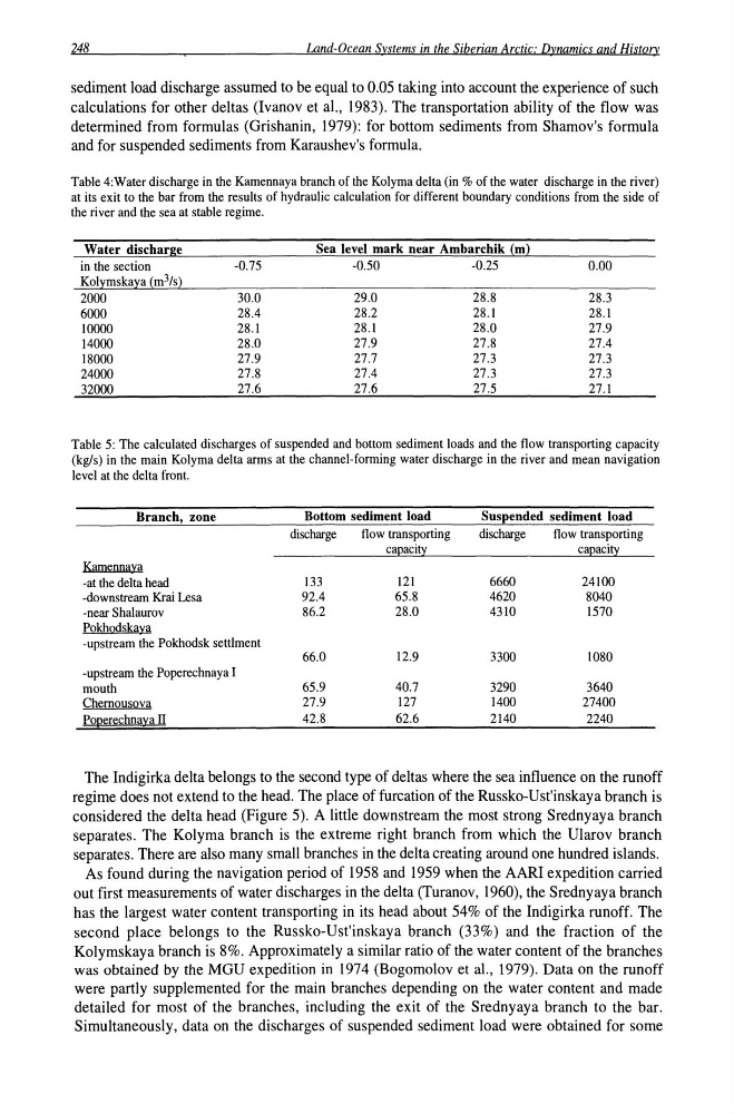
Table 4:Water discharge in the Kamennaya branch of the Kolyma delta (in % of the water discharge in the river)
at its exit to the bar from the results of hydraulic calculation for different boundary conditions from the side of
the river and the sea at stable regime.
Water discharge
Sea level mark near Ambarchik (m)
in the section
-0.75
-0.50
-0.25
0.00
Kolymskaya (m3/s)
2000
30.0
29.0
28.8
28.3
6000
28.4
28.2
28.1
28.1
10000
28.1
28.1
28.0
27.9
14000
28.0
27.9
27.8
27.4
18000
27.9
27.7
27.3
27.3
24000
27.8
27.4
27.3
27.3
32000
27.6
27.6
27.5
27.1
Table 5: The calculated discharges of suspended and bottom sediment loads and the flow transporting capacity
(kg/s) in the main Kolyma delta arms at the channel-fonning water discharge in the river and mean navigation
level at the delta front.
Branch, zone
Bottom sediment load
Suspended sediment load
discharge
flow transporting
discharge
flow transporting
ca~acity
ca~aci!y
Kamennaya
-at the delta head
133
121
6660
24100
-downstream Krai Lesa
92.4
65.8
4620
8040
-near Shalaurov
86.2
28.0
4310
1570
Pokhodskaya
-upstream the Pokhodsk settlment
66.0
12.9
3300
1080
-upstream the Poperechnaya I
mouth
65.9
40.7
3290
3640
Chemousova
27.9
127
1400
27400
POQerechnaya II
42.8
62.6
2140
2240
The Indigirka delta belongs to the second type of deltas where the sea influence on the runoff
regime does not extend to the head. The place of furcation of the Russko-Ust'inskaya branch is
considered the delta head (Figure 5). A little downstream the most strong Srednyaya branch
separates. The Kolyma branch is the extreme right branch from which the Ularov branch
separates. There are also many small branches in the delta creating around one hundred islands.
As found during the navigation period of 1958 and 1959 when the AARI expedition carried
out first measurements of water discharges in the delta (Turanov, 1960), the Srednyaya branch
has the largest water content transporting in its head about 54% of the Indigirka runoff. The
second place belongs to the Russko-Ust'inskaya branch (33%) and the fraction of the
Kolymskaya branch is 8%. Approximately a similar ratio of the water content of the branches
was obtained by the MGU expedition in 1974 (Bogomolov et aI., 1979). Data on the runoff
were partly supplemented for the main branches depending on the water content and made
detailed for most of the branches, including the exit of the Srednyaya branch to the bar.
Simultaneously, data on the discharges of suspended sediment load were obtained for some
Land-Ocean Systems in the Siberian Arctic: Dynamics and History
sediment load discharge assumed to be equal to 0.05 taking into account the experience of such
calculations for other deltas (Ivanov et aI., 1983). The transportation ability of the flow was
determined from formulas (Grishanin, 1979): for bottom sediments from Shamov's formula
and for suspended sediments from Karaushev's formula.
Table 4:Water discharge in the Kamennaya branch of the Kolyma delta (in % of the water discharge in the river)
at its exit to the bar from the results of hydraulic calculation for different boundary conditions from the side of
the river and the sea at stable regime.
Water discharge
Sea level mark near Ambarchik (m)
in the section
-0.75
-0.50
-0.25
0.00
Kolymskaya (m3/s)
2000
30.0
29.0
28.8
28.3
6000
28.4
28.2
28.1
28.1
10000
28.1
28.1
28.0
27.9
14000
28.0
27.9
27.8
27.4
18000
27.9
27.7
27.3
27.3
24000
27.8
27.4
27.3
27.3
32000
27.6
27.6
27.5
27.1
Table 5: The calculated discharges of suspended and bottom sediment loads and the flow transporting capacity
(kg/s) in the main Kolyma delta arms at the channel-fonning water discharge in the river and mean navigation
level at the delta front.
Branch, zone
Bottom sediment load
Suspended sediment load
discharge
flow transporting
discharge
flow transporting
ca~acity
ca~aci!y
Kamennaya
-at the delta head
133
121
6660
24100
-downstream Krai Lesa
92.4
65.8
4620
8040
-near Shalaurov
86.2
28.0
4310
1570
Pokhodskaya
-upstream the Pokhodsk settlment
66.0
12.9
3300
1080
-upstream the Poperechnaya I
mouth
65.9
40.7
3290
3640
Chemousova
27.9
127
1400
27400
POQerechnaya II
42.8
62.6
2140
2240
The Indigirka delta belongs to the second type of deltas where the sea influence on the runoff
regime does not extend to the head. The place of furcation of the Russko-Ust'inskaya branch is
considered the delta head (Figure 5). A little downstream the most strong Srednyaya branch
separates. The Kolyma branch is the extreme right branch from which the Ularov branch
separates. There are also many small branches in the delta creating around one hundred islands.
As found during the navigation period of 1958 and 1959 when the AARI expedition carried
out first measurements of water discharges in the delta (Turanov, 1960), the Srednyaya branch
has the largest water content transporting in its head about 54% of the Indigirka runoff. The
second place belongs to the Russko-Ust'inskaya branch (33%) and the fraction of the
Kolymskaya branch is 8%. Approximately a similar ratio of the water content of the branches
was obtained by the MGU expedition in 1974 (Bogomolov et aI., 1979). Data on the runoff
were partly supplemented for the main branches depending on the water content and made
detailed for most of the branches, including the exit of the Srednyaya branch to the bar.
Simultaneously, data on the discharges of suspended sediment load were obtained for some