

25
North American plate
South American plate
Atlantic Ocean
Caribbean plate
Pacific ocean
−90
−85
−80
−75
−70
−65
−60
20
1
3
2
3
1
SB
SJB
SMM
SM
MA
LN
CCO
APP
SI
NR
CC
WC
EC
2
3
4
4
5
6
7
15
10
5
75°W
14° N
12° N
10° N
8° N
6° N
Eastern Venezuela
foreland basin
Lesser Antilles arc
system
200 km
70°W
6 5 °W
6 0 °W
5 5 °W
Depth to basement
(in meters)
Value
High : 200 m
Low : −12000 m
Sense of horizontal
displacement
Relative plate
motion
Inferred paths of
Proto-Orinoco River
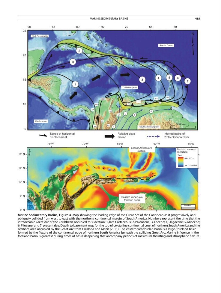
Marine Sedimentary Basins, Figure 4 Map showing the leading edge of the Great Arc of the Caribbean as it progressively and
obliquely collided from west to east with the northern, continental margin of South America. Numbers represent the time that the
intraoceanic Great Arc of the Caribbean occupied this location: 1, late Cretaceous; 2, Paleocene; 3, Eocene; 4, Oligocene; 5, Miocene;
6, Pliocene; and 7, present day. Depth to basement map for the top of crystalline continental crust of northern South America and the
offshore area occupied by the Great Arc from Escalona and Mann (2011). The eastern Venezuelan basin is a large, foreland basin
formed by the flexure of the continental edge of northern South America beneath the colliding Great Arc. Marine influence in the
foreland basin is greatest during times of basin deepening that accompany periods of maximum thrusting and lithospheric flexure.
MARINE SEDIMENTARY BASINS
485