

Bibliography
Becker, J. J., Sandwell, D. T., Smith, W. H. F., Braud, J., Binder, B.,
Depner, J., Fabre, D., Factor, J., Ingalls, S., Kim, S. H., Ladner,
R., Marks, K., Nelson, S., Pharaoh, A., Trimmer, R., Von
Rosenberg, J., Wallace, G., and Weatherall, P., 2009. Global
bathymetry and elevation data at 30 arc seconds resolution:
SRTM30_PLUS. Marine Geodesy, 32, 355–371.
Harris, P. T., Macmillan-Lawler, M., Rupp, J., and Baker, E. K.,
2014. Geomorphology of the oceans. Marine Geology, 352,
4–24.
Heezen, B.C., Tharp, M., 1977. World ocean floor panorama. In full
color, painted by H. Berann, Mercator Projection, scale
1:23,230,300, 1168 Â 1930mm, New York.
IHO, 2008. Standardization of Undersea Feature Names: Guidelines Proposal form Terminology, 4th edn. Monaco: International Hydrographic Organisation and Intergovernmental
Oceanographic Commission.
Müller, D., Sdrolias, M., Gaina, C., and Roest, W. R., 2008. Age,
spreading rates, and spreading asymmetry of the world’s ocean
crust. Geochemistry, Geophysics, Geosystems, 9(4),
doi:10.1029/2007GC001743.
Ryan, W. B. F., Carbotte, S. M., Coplan, J. O., O’Hara, S.,
Melkonian, A., Arko, R., Weissel, R. A., Ferrini, V., Goodwillie,
A., Nitsche, F., Bonczkowski, J., and Zemsky, R., 2009. Global -
multi-resolution
topography
synthesis.
Geochemistry,
Geophysics, Geosystems, 10, Q03014.
Smith, W. H. F., and Sandwell, D. T., 1995. Bathymetric prediction
from dense satellite altimetry and sparse shipboard bathymetry.
Oceanographic Literature Review, 42, 409.
Whittaker, J. M., Goncharov, A., Williams, S. E., Müller, R. D., and
Leitchenkov, G., 2013. Global sediment thickness data
set updated for the Australian-Antarctic Southern Ocean.
Geochemistry, Geophysics, Geosystems, 14, 3297–3305.
Cross-references
Calcite Compensation Depth (CCD)
Intraoceanic Subduction Zone
Mid-ocean Ridge Magmatism and Volcanism
Oceanic Plateaus
Seamounts
Subsidence of Oceanic Crust
Turbidites
Upwelling
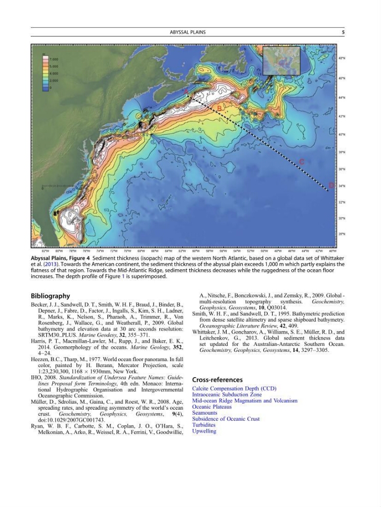
Abyssal Plains, Figure 4 Sediment thickness (isopach) map of the western North Atlantic, based on a global data set of Whittaker
et al. (2013). Towards the American continent, the sediment thickness of the abyssal plain exceeds 1,000 m which partly explains the
flatness of that region. Towards the Mid-Atlantic Ridge, sediment thickness decreases while the ruggedness of the ocean floor
increases. The depth profile of Figure 1 is superimposed.
ABYSSAL PLAINS
5
Becker, J. J., Sandwell, D. T., Smith, W. H. F., Braud, J., Binder, B.,
Depner, J., Fabre, D., Factor, J., Ingalls, S., Kim, S. H., Ladner,
R., Marks, K., Nelson, S., Pharaoh, A., Trimmer, R., Von
Rosenberg, J., Wallace, G., and Weatherall, P., 2009. Global
bathymetry and elevation data at 30 arc seconds resolution:
SRTM30_PLUS. Marine Geodesy, 32, 355–371.
Harris, P. T., Macmillan-Lawler, M., Rupp, J., and Baker, E. K.,
2014. Geomorphology of the oceans. Marine Geology, 352,
4–24.
Heezen, B.C., Tharp, M., 1977. World ocean floor panorama. In full
color, painted by H. Berann, Mercator Projection, scale
1:23,230,300, 1168 Â 1930mm, New York.
IHO, 2008. Standardization of Undersea Feature Names: Guidelines Proposal form Terminology, 4th edn. Monaco: International Hydrographic Organisation and Intergovernmental
Oceanographic Commission.
Müller, D., Sdrolias, M., Gaina, C., and Roest, W. R., 2008. Age,
spreading rates, and spreading asymmetry of the world’s ocean
crust. Geochemistry, Geophysics, Geosystems, 9(4),
doi:10.1029/2007GC001743.
Ryan, W. B. F., Carbotte, S. M., Coplan, J. O., O’Hara, S.,
Melkonian, A., Arko, R., Weissel, R. A., Ferrini, V., Goodwillie,
A., Nitsche, F., Bonczkowski, J., and Zemsky, R., 2009. Global -
multi-resolution
topography
synthesis.
Geochemistry,
Geophysics, Geosystems, 10, Q03014.
Smith, W. H. F., and Sandwell, D. T., 1995. Bathymetric prediction
from dense satellite altimetry and sparse shipboard bathymetry.
Oceanographic Literature Review, 42, 409.
Whittaker, J. M., Goncharov, A., Williams, S. E., Müller, R. D., and
Leitchenkov, G., 2013. Global sediment thickness data
set updated for the Australian-Antarctic Southern Ocean.
Geochemistry, Geophysics, Geosystems, 14, 3297–3305.
Cross-references
Calcite Compensation Depth (CCD)
Intraoceanic Subduction Zone
Mid-ocean Ridge Magmatism and Volcanism
Oceanic Plateaus
Seamounts
Subsidence of Oceanic Crust
Turbidites
Upwelling
Abyssal Plains, Figure 4 Sediment thickness (isopach) map of the western North Atlantic, based on a global data set of Whittaker
et al. (2013). Towards the American continent, the sediment thickness of the abyssal plain exceeds 1,000 m which partly explains the
flatness of that region. Towards the Mid-Atlantic Ridge, sediment thickness decreases while the ruggedness of the ocean floor
increases. The depth profile of Figure 1 is superimposed.
ABYSSAL PLAINS
5