

coastlines is based on geomorphological and sedimentological work. There is the potential for both sedimentary
and erosional evidence. Paleostorm deposits may form
individual layers which differ from the coastal facies.
Such sandy event deposits are found as stratified, often
shelly strata in back barrier lagoons and swamps where
fine-grained sediments usually accumulate (e.g., Switzer
and Jones, 2008). The deposits are commonly tens of centimeters thick and usually laminated due to individual
wave pulses. Paleosoils are useful indicators in coastal
profiles when overlain by a suspicious deposit. This indicates a hiatus that covers at least the time of soil formation
and underlines the event character of the deposit. Geomorphological evidence of paleostorms can be seen in coastal
ridges and splays. Landward thinning sheets, which
appear as fan-shaped tongues in the coastal geomorphology, form as a consequence of the overtopping of dune
morphology and the breaching of barriers and berms along
sandy coasts. Besides these fine-grained sandy deposits,
coarse-grained coastal deposits such as boulders have
been described as built by tropical cyclones (e.g.,
Scheffers and Scheffers, 2006). Cox et al. (2012) convincingly demonstrate extratropical storm activation of boulder deposits along the west coast of Ireland. Another
deposit associated with storm surges is wrack lines. These
are composed of floatable material. Although the preservation potential might be low, Hoffmann and Reicherter
(2014) recently documented how these deposits may be
used to precisely date the flooding event. In general,
reworking of older material along the shore is common
during storm surge impact, and this may hamper dating
of the event deposits.
Paleotsunami
Tsunami action is mirrored in geological records and
archives as phases of erosion, reworking, and redeposition
leaving unconformities and unusual sedimentary layers.
Tsunamites or tsunami deposits are proof that past or prehistoric tsunami events have occurred along coastlines or
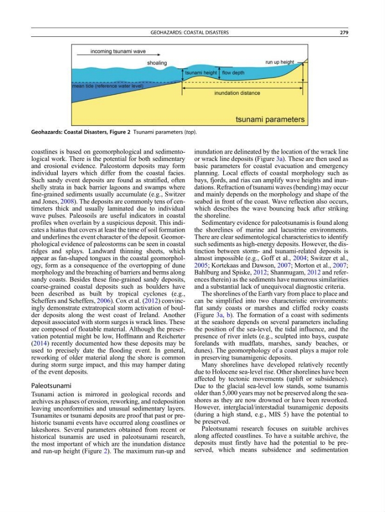
lakeshores. Several parameters obtained from recent or
historical tsunamis are used in paleotsunami research,
the most important of which are the inundation distance
and run-up height (Figure 2). The maximum run-up and
inundation are delineated by the location of the wrack line
or wrack line deposits (Figure 3a). These are then used as
basic parameters for coastal evacuation and emergency
planning. Local effects of coastal morphology such as
bays, fjords, and rias can amplify wave heights and inundations. Refraction of tsunami waves (bending) may occur
and mainly depends on the morphology and shape of the
seabed in front of the coast. Wave reflection also occurs,
which describes the wave bouncing back after striking
the shoreline.
Sedimentary evidence for paleotsunamis is found along
the shorelines of marine and lacustrine environments.
There are clear sedimentological characteristics to identify
such sediments as high-energy deposits. However, the distinction between storm- and tsunami-related deposits is
almost impossible (e.g., Goff et al., 2004; Switzer et al.,
2005; Kortekaas and Dawson, 2007; Morton et al., 2007;
Bahlburg and Spiske, 2012; Shanmugam, 2012 and references therein) as the sediments have numerous similarities
and a substantial lack of unequivocal diagnostic criteria.
The shorelines of the Earth vary from place to place and
can be simplified into two characteristic environments:
flat sandy coasts or marshes and cliffed rocky coasts
(Figure 3a, b). The formation of a coast with sediments
at the seashore depends on several parameters including
the position of the sea-level, the tidal influence, and the
presence of river inlets (e.g., sculpted into bays, cuspate
forelands with mudflats, marshes, sandy beaches, or
dunes). The geomorphology of a coast plays a major role
in preserving tsunamigenic deposits.
Many shorelines have developed relatively recently
due to Holocene sea-level rise. Other shorelines have been
affected by tectonic movements (uplift or subsidence).
Due to the glacial sea-level low stands, some tsunamis
older than 5,000 years may not be preserved along the seashores as they are now drowned or have been reworked.
However, interglacial/interstadial tsunamigenic deposits
(during a high stand, e.g., MIS 5) have the potential to
be preserved.
Paleotsunami research focuses on suitable archives
along affected coastlines. To have a suitable archive, the
deposits must firstly have had the potential to be preserved, which means subsidence and sedimentation
Geohazards: Coastal Disasters, Figure 2 Tsunami parameters (top).
GEOHAZARDS: COASTAL DISASTERS
279
and erosional evidence. Paleostorm deposits may form
individual layers which differ from the coastal facies.
Such sandy event deposits are found as stratified, often
shelly strata in back barrier lagoons and swamps where
fine-grained sediments usually accumulate (e.g., Switzer
and Jones, 2008). The deposits are commonly tens of centimeters thick and usually laminated due to individual
wave pulses. Paleosoils are useful indicators in coastal
profiles when overlain by a suspicious deposit. This indicates a hiatus that covers at least the time of soil formation
and underlines the event character of the deposit. Geomorphological evidence of paleostorms can be seen in coastal
ridges and splays. Landward thinning sheets, which
appear as fan-shaped tongues in the coastal geomorphology, form as a consequence of the overtopping of dune
morphology and the breaching of barriers and berms along
sandy coasts. Besides these fine-grained sandy deposits,
coarse-grained coastal deposits such as boulders have
been described as built by tropical cyclones (e.g.,
Scheffers and Scheffers, 2006). Cox et al. (2012) convincingly demonstrate extratropical storm activation of boulder deposits along the west coast of Ireland. Another
deposit associated with storm surges is wrack lines. These
are composed of floatable material. Although the preservation potential might be low, Hoffmann and Reicherter
(2014) recently documented how these deposits may be
used to precisely date the flooding event. In general,
reworking of older material along the shore is common
during storm surge impact, and this may hamper dating
of the event deposits.
Paleotsunami
Tsunami action is mirrored in geological records and
archives as phases of erosion, reworking, and redeposition
leaving unconformities and unusual sedimentary layers.
Tsunamites or tsunami deposits are proof that past or prehistoric tsunami events have occurred along coastlines or
lakeshores. Several parameters obtained from recent or
historical tsunamis are used in paleotsunami research,
the most important of which are the inundation distance
and run-up height (Figure 2). The maximum run-up and
inundation are delineated by the location of the wrack line
or wrack line deposits (Figure 3a). These are then used as
basic parameters for coastal evacuation and emergency
planning. Local effects of coastal morphology such as
bays, fjords, and rias can amplify wave heights and inundations. Refraction of tsunami waves (bending) may occur
and mainly depends on the morphology and shape of the
seabed in front of the coast. Wave reflection also occurs,
which describes the wave bouncing back after striking
the shoreline.
Sedimentary evidence for paleotsunamis is found along
the shorelines of marine and lacustrine environments.
There are clear sedimentological characteristics to identify
such sediments as high-energy deposits. However, the distinction between storm- and tsunami-related deposits is
almost impossible (e.g., Goff et al., 2004; Switzer et al.,
2005; Kortekaas and Dawson, 2007; Morton et al., 2007;
Bahlburg and Spiske, 2012; Shanmugam, 2012 and references therein) as the sediments have numerous similarities
and a substantial lack of unequivocal diagnostic criteria.
The shorelines of the Earth vary from place to place and
can be simplified into two characteristic environments:
flat sandy coasts or marshes and cliffed rocky coasts
(Figure 3a, b). The formation of a coast with sediments
at the seashore depends on several parameters including
the position of the sea-level, the tidal influence, and the
presence of river inlets (e.g., sculpted into bays, cuspate
forelands with mudflats, marshes, sandy beaches, or
dunes). The geomorphology of a coast plays a major role
in preserving tsunamigenic deposits.
Many shorelines have developed relatively recently
due to Holocene sea-level rise. Other shorelines have been
affected by tectonic movements (uplift or subsidence).
Due to the glacial sea-level low stands, some tsunamis
older than 5,000 years may not be preserved along the seashores as they are now drowned or have been reworked.
However, interglacial/interstadial tsunamigenic deposits
(during a high stand, e.g., MIS 5) have the potential to
be preserved.
Paleotsunami research focuses on suitable archives
along affected coastlines. To have a suitable archive, the
deposits must firstly have had the potential to be preserved, which means subsidence and sedimentation
Geohazards: Coastal Disasters, Figure 2 Tsunami parameters (top).
GEOHAZARDS: COASTAL DISASTERS
279