

of all other causes – impact tsunamis are very rare
(Rhodes et al., 2006). Eighty percent of all tsunamis occur
in the Pacific Ocean, but other oceans and seas (like the
Mediterranean Sea) have also been affected by tsunamis.
Tsunami evidence has also been documented on the shorelines of large and deep lakes, such as Lake Geneva in Switzerland (Kremer et al., 2012). The speed of a tsunami wave
is calculated by the square root of the product of acceleration by gravity (9.8 m/s
2
) and the water depth; in deep
water, the wavelength of the tsunami must also be taken
into account. Extreme waves can also be induced by storms
and become tsunamis when approaching the coastline due
to shoaling. These are then referred to as meteotsunamis
(Monserrat et al., 2006). Shoaling can result in the superposition of waves and a dramatic reduction in wave velocity.
The plural form is “tsunamis” or “tsunami.”
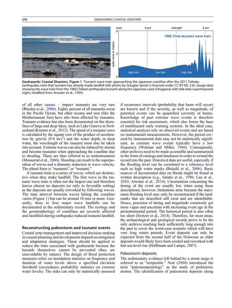
A tsunami train is a series of waves, which are destructive when they make landfall. The first wave in the tsunami wave train is often not the largest one and therefore
leaves almost no deposits (or only in favorable setting)
as the deposits are usually reworked by following waves.
The time interval between waves hitting the coastline
varies (Figure 1) but can be around 10 min or more. Generally, three to four major wave landfalls can be
documented in the sedimentary record. The ecology and
the geomorphology of coastlines are severely affected
and modified during earthquake-induced tsunami landfall.
Reconstructing paleostorm and tsunami events
Coastal zone management and improved decision-making
in coastal planning and development depend on mitigation
and adaptation strategies. These should be applied to
reduce the risks associated with geohazards because the
hazards themselves cannot be prevented (they are
unavoidable by nature). The design of flood protection
measures relies on inundation statistics on frequency and
duration of water levels above a specified elevation
threshold (exceedance probability statistics on extreme
water levels). The risks can only be statistically assessed
if recurrence intervals (probability that harm will occur)
are known and if the severity, as well as magnitude, of
potential events can be quantified (severity of harm).
Knowledge of past extreme wave events is therefore
essential for risk assessment, which also forms the base
of multihazard early warning systems. In the ideal case,
statistical analyses rely on observed events and are based
on instrumental measurements. However, the period covered by instrumental data may not be statistically significant, as extreme wave events typically have a low
frequency (Wolman and Miller, 1960). Consequently,
other archives need to be made accessible and summarized
in the form of catalogs and databases in order to extend the
record into the past. Historical data are useful, especially if
the flooding level can be correlated to a reference level
such as high water marks (Brázdil et al., 2006). Basic
sources of documented data on floods might be found in
written description (e.g., Satake et al., 1996; Lau et al.,
2010; Atwater et al., 2014). Uncertainties concerning the
timing of the event are usually low when using these
descriptions; however, limitations arise because the maximum flooding level may only be reconstructed if the landmarks that are described still exist and are identifiable.
Hence, precision of dating and magnitude commonly get
more vague and uncertain with increasing event age in the
preinstrumental period. The historical period is also often
too short (Switzer et al., 2014). Therefore, for most areas,
the archaeological and geological records prove to be the
only archives reaching back sufficiently long enough into
the past to cover the worst-case scenario which will have
very long return periods. Event deposits can only be
expected from the second half of the Holocene as older
deposits would likely have been eroded and reworked with
fast sea-level rise (Hoffmann and Lampe, 2007).
Paleostorm deposits
The sedimentary evidence left behind by a storm surge is
referred to as “tempestite.” Nott (2004) introduced the
term “paleotempestology” as the study of prehistoric
storms. The identification of paleostorm deposits along
Geohazards: Coastal Disasters, Figure 1 Tsunami wave train approaching the Japanese coastline after the 2011 Tohoku
earthquake; note that tsunami has already made landfall (left; photo by Douglas Sprott is licensed under CC BY-NC 2.0). Gauge data
showing the wave train from the 1960 Chilean earthquake tsunami along the Japanese coast (Onagawa) with tide data superimposed
(right; modified from Atwater et al., 1999).
278
GEOHAZARDS: COASTAL DISASTERS
(Rhodes et al., 2006). Eighty percent of all tsunamis occur
in the Pacific Ocean, but other oceans and seas (like the
Mediterranean Sea) have also been affected by tsunamis.
Tsunami evidence has also been documented on the shorelines of large and deep lakes, such as Lake Geneva in Switzerland (Kremer et al., 2012). The speed of a tsunami wave
is calculated by the square root of the product of acceleration by gravity (9.8 m/s
2
) and the water depth; in deep
water, the wavelength of the tsunami must also be taken
into account. Extreme waves can also be induced by storms
and become tsunamis when approaching the coastline due
to shoaling. These are then referred to as meteotsunamis
(Monserrat et al., 2006). Shoaling can result in the superposition of waves and a dramatic reduction in wave velocity.
The plural form is “tsunamis” or “tsunami.”
A tsunami train is a series of waves, which are destructive when they make landfall. The first wave in the tsunami wave train is often not the largest one and therefore
leaves almost no deposits (or only in favorable setting)
as the deposits are usually reworked by following waves.
The time interval between waves hitting the coastline
varies (Figure 1) but can be around 10 min or more. Generally, three to four major wave landfalls can be
documented in the sedimentary record. The ecology and
the geomorphology of coastlines are severely affected
and modified during earthquake-induced tsunami landfall.
Reconstructing paleostorm and tsunami events
Coastal zone management and improved decision-making
in coastal planning and development depend on mitigation
and adaptation strategies. These should be applied to
reduce the risks associated with geohazards because the
hazards themselves cannot be prevented (they are
unavoidable by nature). The design of flood protection
measures relies on inundation statistics on frequency and
duration of water levels above a specified elevation
threshold (exceedance probability statistics on extreme
water levels). The risks can only be statistically assessed
if recurrence intervals (probability that harm will occur)
are known and if the severity, as well as magnitude, of
potential events can be quantified (severity of harm).
Knowledge of past extreme wave events is therefore
essential for risk assessment, which also forms the base
of multihazard early warning systems. In the ideal case,
statistical analyses rely on observed events and are based
on instrumental measurements. However, the period covered by instrumental data may not be statistically significant, as extreme wave events typically have a low
frequency (Wolman and Miller, 1960). Consequently,
other archives need to be made accessible and summarized
in the form of catalogs and databases in order to extend the
record into the past. Historical data are useful, especially if
the flooding level can be correlated to a reference level
such as high water marks (Brázdil et al., 2006). Basic
sources of documented data on floods might be found in
written description (e.g., Satake et al., 1996; Lau et al.,
2010; Atwater et al., 2014). Uncertainties concerning the
timing of the event are usually low when using these
descriptions; however, limitations arise because the maximum flooding level may only be reconstructed if the landmarks that are described still exist and are identifiable.
Hence, precision of dating and magnitude commonly get
more vague and uncertain with increasing event age in the
preinstrumental period. The historical period is also often
too short (Switzer et al., 2014). Therefore, for most areas,
the archaeological and geological records prove to be the
only archives reaching back sufficiently long enough into
the past to cover the worst-case scenario which will have
very long return periods. Event deposits can only be
expected from the second half of the Holocene as older
deposits would likely have been eroded and reworked with
fast sea-level rise (Hoffmann and Lampe, 2007).
Paleostorm deposits
The sedimentary evidence left behind by a storm surge is
referred to as “tempestite.” Nott (2004) introduced the
term “paleotempestology” as the study of prehistoric
storms. The identification of paleostorm deposits along
Geohazards: Coastal Disasters, Figure 1 Tsunami wave train approaching the Japanese coastline after the 2011 Tohoku
earthquake; note that tsunami has already made landfall (left; photo by Douglas Sprott is licensed under CC BY-NC 2.0). Gauge data
showing the wave train from the 1960 Chilean earthquake tsunami along the Japanese coast (Onagawa) with tide data superimposed
(right; modified from Atwater et al., 1999).
278
GEOHAZARDS: COASTAL DISASTERS