

232
K. Döös et al.
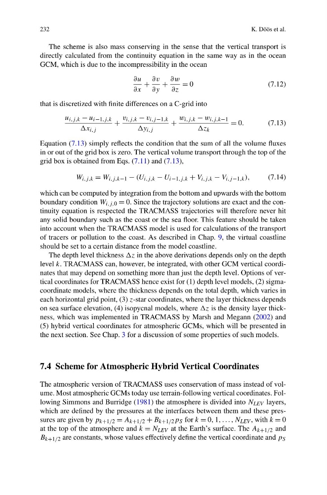
The scheme is also mass conserving in the sense that the vertical transport is
directly calculated from the continuity equation in the same way as in the ocean
GCM, which is due to the incompressibility in the ocean
∂u
∂x
+
∂v
∂y
+
∂w
∂z
= 0
(7.12)
that is discretized with finite differences on a C-grid into
u i,j,k − u i−1,j,k
x i,j
+
v i,j,k − v i,j −1,k
y i,j
+
w i,j,k − w i,j,k−1
z k
= 0.
(7.13)
Equation (7.13) simply reflects the condition that the sum of all the volume fluxes
in or out of the grid box is zero. The vertical volume transport through the top of the
grid box is obtained from Eqs. (7.11) and (7.13),
W i,j,k = W i,j,k−1 − (U i,j,k − U i−1,j,k + V i,j,k − V i,j −1,k ),
(7.14)
which can be computed by integration from the bottom and upwards with the bottom
boundary condition W i,j,0 = 0. Since the trajectory solutions are exact and the continuity equation is respected the TRACMASS trajectories will therefore never hit
any solid boundary such as the coast or the sea floor. This feature should be taken
into account when the TRACMASS model is used for calculations of the transport
of tracers or pollution to the coast. As described in Chap. 9, the virtual coastline
should be set to a certain distance from the model coastline.
The depth level thickness z in the above derivations depends only on the depth
level k. TRACMASS can, however, be integrated, with other GCM vertical coordinates that may depend on something more than just the depth level. Options of vertical coordinates for TRACMASS hence exist for (1) depth level models, (2) sigmacoordinate models, where the thickness depends on the total depth, which varies in
each horizontal grid point, (3) z-star coordinates, where the layer thickness depends
on sea surface elevation, (4) isopycnal models, where z is the density layer thickness, which was implemented in TRACMASS by Marsh and Megann (2002) and
(5) hybrid vertical coordinates for atmospheric GCMs, which will be presented in
the next section. See Chap. 3 for a discussion of some properties of such models.
7.4 Scheme for Atmospheric Hybrid Vertical Coordinates
The atmospheric version of TRACMASS uses conservation of mass instead of volume. Most atmospheric GCMs today use terrain-following vertical coordinates. Following Simmons and Burridge (1981) the atmosphere is divided into N LEV layers,
which are defined by the pressures at the interfaces between them and these pressures are given by p k+1/2 = A k+1/2 + B k+1/2 p S for k = 0, 1, . . . , N LEV , with k = 0
at the top of the atmosphere and k = N LEV at the Earth’s surface. The A k+1/2 and
B k+1/2 are constants, whose values effectively define the vertical coordinate and p S
K. Döös et al.
The scheme is also mass conserving in the sense that the vertical transport is
directly calculated from the continuity equation in the same way as in the ocean
GCM, which is due to the incompressibility in the ocean
∂u
∂x
+
∂v
∂y
+
∂w
∂z
= 0
(7.12)
that is discretized with finite differences on a C-grid into
u i,j,k − u i−1,j,k
x i,j
+
v i,j,k − v i,j −1,k
y i,j
+
w i,j,k − w i,j,k−1
z k
= 0.
(7.13)
Equation (7.13) simply reflects the condition that the sum of all the volume fluxes
in or out of the grid box is zero. The vertical volume transport through the top of the
grid box is obtained from Eqs. (7.11) and (7.13),
W i,j,k = W i,j,k−1 − (U i,j,k − U i−1,j,k + V i,j,k − V i,j −1,k ),
(7.14)
which can be computed by integration from the bottom and upwards with the bottom
boundary condition W i,j,0 = 0. Since the trajectory solutions are exact and the continuity equation is respected the TRACMASS trajectories will therefore never hit
any solid boundary such as the coast or the sea floor. This feature should be taken
into account when the TRACMASS model is used for calculations of the transport
of tracers or pollution to the coast. As described in Chap. 9, the virtual coastline
should be set to a certain distance from the model coastline.
The depth level thickness z in the above derivations depends only on the depth
level k. TRACMASS can, however, be integrated, with other GCM vertical coordinates that may depend on something more than just the depth level. Options of vertical coordinates for TRACMASS hence exist for (1) depth level models, (2) sigmacoordinate models, where the thickness depends on the total depth, which varies in
each horizontal grid point, (3) z-star coordinates, where the layer thickness depends
on sea surface elevation, (4) isopycnal models, where z is the density layer thickness, which was implemented in TRACMASS by Marsh and Megann (2002) and
(5) hybrid vertical coordinates for atmospheric GCMs, which will be presented in
the next section. See Chap. 3 for a discussion of some properties of such models.
7.4 Scheme for Atmospheric Hybrid Vertical Coordinates
The atmospheric version of TRACMASS uses conservation of mass instead of volume. Most atmospheric GCMs today use terrain-following vertical coordinates. Following Simmons and Burridge (1981) the atmosphere is divided into N LEV layers,
which are defined by the pressures at the interfaces between them and these pressures are given by p k+1/2 = A k+1/2 + B k+1/2 p S for k = 0, 1, . . . , N LEV , with k = 0
at the top of the atmosphere and k = N LEV at the Earth’s surface. The A k+1/2 and
B k+1/2 are constants, whose values effectively define the vertical coordinate and p S