

146
E.V. Stanev and X. Lu
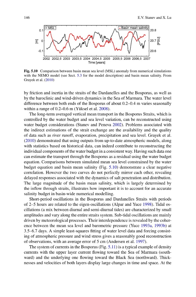
Fig. 5.10 Comparison between basin mean sea level (MSL) anomaly from numerical simulations
with the NEMO model (see Sect. 5.3 for the model description) and basin mean salinity. From
Grayek et al. (2010)
by friction and inertia in the straits of the Dardanelles and the Bosporus, as well as
by the baroclinic and wind-driven dynamics in the Sea of Marmara. The water level
difference between both ends of the Bosporus of about 0.2–0.4 m varies seasonally
within a range of 0.2–0.6 m (Yüksel et al. 2008).
The long-term averaged vertical mean transport in the Bosporus Straits, which is
controlled by the water budget and sea level variation, can be reconstructed using
water budget considerations (Stanev and Peneva 2002). Problems associated with
the indirect estimations of the strait exchange are the availability and the quality
of data such as river runoff, evaporation, precipitation and sea level. Grayek et al.
(2010) demonstrated that using outputs from up-to-date atmospheric models, along
with statistics based on historical data, can indeed contribute to reconstructing the
individual components of the water budget in a consistent way. Having such data one
can estimate the transport through the Bosporus as a residual using the water budget
equation. Comparisons between simulated mean sea level constrained by the water
budget equation and basin mean salinity (Fig. 5.10) demonstrate a clear negative
correlation. However the two curves do not perfectly mirror each other, revealing
delayed responses associated with the dynamics of salt penetration and distribution.
The large magnitude of the basin mean salinity, which is largely determined by
the inflow through straits, illustrates how important it is to account for an accurate
salinity budget in basin-wide numerical modelling.
Short-period oscillations in the Bosporus and Dardanelles Straits with periods
of 2–5 hours are related to the eigen-oscillations (Alpar and Yuce 1998). Tidal oscillations (a mix between diurnal and semi-diurnal tides) are characterized by small
amplitudes and vary along the entire straits system. Sub-tidal oscillations are mainly
driven by meteorological processes. Their interdependence is revealed by the coherence between the mean sea level and barometric pressure (Yuce 1993a, 1993b) at
3.5–6.7 days. A simple least-squares fitting of water level data and forcing consisting of atmospheric pressure and wind stress gives a reasonably good reconstruction
of observations, with an average error of 5 cm (Andersen et al. 1997).
The system of currents in the Bosporus (Fig. 5.11) is a typical example of density
currents with the upper layer current flowing toward the Sea of Marmara (southward) and the underlying one flowing toward the Black Sea (northward). Thicknesses and velocities of both layers display large changes in time and space. At the
E.V. Stanev and X. Lu
Fig. 5.10 Comparison between basin mean sea level (MSL) anomaly from numerical simulations
with the NEMO model (see Sect. 5.3 for the model description) and basin mean salinity. From
Grayek et al. (2010)
by friction and inertia in the straits of the Dardanelles and the Bosporus, as well as
by the baroclinic and wind-driven dynamics in the Sea of Marmara. The water level
difference between both ends of the Bosporus of about 0.2–0.4 m varies seasonally
within a range of 0.2–0.6 m (Yüksel et al. 2008).
The long-term averaged vertical mean transport in the Bosporus Straits, which is
controlled by the water budget and sea level variation, can be reconstructed using
water budget considerations (Stanev and Peneva 2002). Problems associated with
the indirect estimations of the strait exchange are the availability and the quality
of data such as river runoff, evaporation, precipitation and sea level. Grayek et al.
(2010) demonstrated that using outputs from up-to-date atmospheric models, along
with statistics based on historical data, can indeed contribute to reconstructing the
individual components of the water budget in a consistent way. Having such data one
can estimate the transport through the Bosporus as a residual using the water budget
equation. Comparisons between simulated mean sea level constrained by the water
budget equation and basin mean salinity (Fig. 5.10) demonstrate a clear negative
correlation. However the two curves do not perfectly mirror each other, revealing
delayed responses associated with the dynamics of salt penetration and distribution.
The large magnitude of the basin mean salinity, which is largely determined by
the inflow through straits, illustrates how important it is to account for an accurate
salinity budget in basin-wide numerical modelling.
Short-period oscillations in the Bosporus and Dardanelles Straits with periods
of 2–5 hours are related to the eigen-oscillations (Alpar and Yuce 1998). Tidal oscillations (a mix between diurnal and semi-diurnal tides) are characterized by small
amplitudes and vary along the entire straits system. Sub-tidal oscillations are mainly
driven by meteorological processes. Their interdependence is revealed by the coherence between the mean sea level and barometric pressure (Yuce 1993a, 1993b) at
3.5–6.7 days. A simple least-squares fitting of water level data and forcing consisting of atmospheric pressure and wind stress gives a reasonably good reconstruction
of observations, with an average error of 5 cm (Andersen et al. 1997).
The system of currents in the Bosporus (Fig. 5.11) is a typical example of density
currents with the upper layer current flowing toward the Sea of Marmara (southward) and the underlying one flowing toward the Black Sea (northward). Thicknesses and velocities of both layers display large changes in time and space. At the