

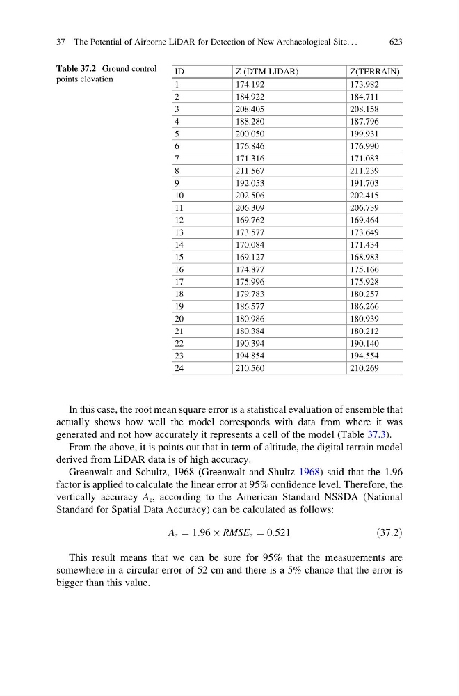
In this case, the root mean square error is a statistical evaluation of ensemble that
actually shows how well the model corresponds with data from where it was
generated and not how accurately it represents a cell of the model (Table 37.3).
From the above, it is points out that in term of altitude, the digital terrain model
derived from LiDAR data is of high accuracy.
Greenwalt and Schultz, 1968 (Greenwalt and Shultz 1968) said that the 1.96
factor is applied to calculate the linear error at 95% confidence level. Therefore, the
vertically accuracy A z , according to the American Standard NSSDA (National
Standard for Spatial Data Accuracy) can be calculated as follows:
A z ¼ 1:96 Â RMSE z ¼ 0:521
ð37:2Þ
This result means that we can be sure for 95% that the measurements are
somewhere in a circular error of 52 cm and there is a 5% chance that the error is
bigger than this value.
Table 37.2 Ground control
points elevation
ID
Z (DTM LIDAR)
Z(TERRAIN)
1
174.192
173.982
2
184.922
184.711
3
208.405
208.158
4
188.280
187.796
5
200.050
199.931
6
176.846
176.990
7
171.316
171.083
8
211.567
211.239
9
192.053
191.703
10
202.506
202.415
11
206.309
206.739
12
169.762
169.464
13
173.577
173.649
14
170.084
171.434
15
169.127
168.983
16
174.877
175.166
17
175.996
175.928
18
179.783
180.257
19
186.577
186.266
20
180.986
180.939
21
180.384
180.212
22
190.394
190.140
23
194.854
194.554
24
210.560
210.269
37 The Potential of Airborne LiDAR for Detection of New Archaeological Site. . .
623