

10
G.A. Schultz and E.T. Engman
I
I
.020 '0'9
rOTA
GAMMA
..... V
COVNTS.
GAMMA
..... V
en
><
<;
~
SPfCTROM ETRV
HEflTI:
I
I
I
I
I
•
I
I
I
I
I
I
I FREOUENCY
10 18 10'7 1016 10 1 & 10" 10'3 10'2 10" 10'0 10 9 10 8 10 7 106 (CYCLES PER
I I I CC I
I
SECONDI
w
I~I~I
ZW
I
>
I
'"
<~
~
0
>~
I~I~I
::Ii'"
.. C
"u.. I
I " .. <
x
_z
a:
>l:a:
c -
o
wO:
51
I
I I I
::Ii:!
I
METERS
lnm
X-RAY
ATOMiC
IMA.GING
IMAGING A.BSOAPTION
SINGlEANO
~PECTR().
MUt TI·lE.NS
PHOTOMETRV, CAMERAS.
MfCHANICAL VARIOUS AlM
L1Hf
EMULSIONS,
SCANNING
Mut TlSPE.CTAAl.
PtK)TOGfW'I
1m
TRANSMISSION
THROUGH
ATMOSPHERE
iWooMETRY.
PASSIVE
ELECTRO
PRINCIPAL
SPECTROMETRY. MICROWAVE MAGNETIC TECHNIOUES FOR
_ RMOO ....... y :::~ .. nAv. SENS G
REMOTE SEN SING
IMAGING
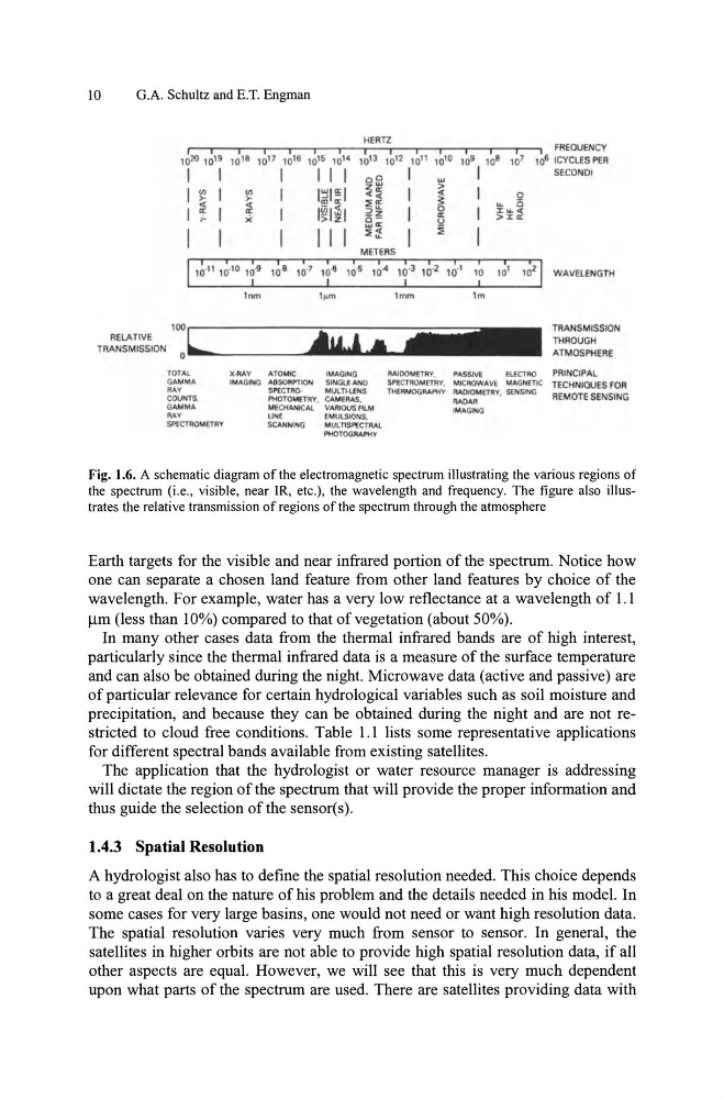
Fig. 1.6. A schematic diagram of the electromagnetic spectrum illustrating the various regions of
the spectrum (i.e., visible, near lR, etc.), the wavelength and frequency. The figure also illustrates the relative transmission of regions of the spectrum through the atmosphere
Earth targets for the visible and near infrared portion of the spectrum. Notice how
one can separate a chosen land feature from other land features by choice of the
wavelength. For example, water has a very low reflectance at a wavelength of 1.1
)lm (less than 10%) compared to that of vegetation (about 50%).
In many other cases data from the thermal infrared bands are of high interest,
particularly since the thermal infrared data is a measure of the surface temperature
and can also be obtained during the night. Microwave data (active and passive) are
of particular relevance for certain hydrological variables such as soil moisture and
precipitation, and because they can be obtained during the night and are not restricted to cloud free conditions. Table 1.1 lists some representative applications
for different spectral bands available from existing satellites.
The application that the hydrologist or water resource manager is addressing
will dictate the region of the spectrum that will provide the proper information and
thus guide the selection of the sensor(s).
1.4.3 Spatial Resolution
A hydrologist also has to define the spatial resolution needed. This choice depends
to a great deal on the nature of his problem and the details needed in his model. In
some cases for very large basins, one would not need or want high resolution data.
The spatial resolution varies very much from sensor to sensor. In general, the
satellites in higher orbits are not able to provide high spatial resolution data, if all
other aspects are equal. However, we will see that this is very much dependent
upon what parts of the spectrum are used. There are satellites providing data with
G.A. Schultz and E.T. Engman
I
I
.020 '0'9
rOTA
GAMMA
..... V
COVNTS.
GAMMA
..... V
en
><
<;
~
SPfCTROM ETRV
HEflTI:
I
I
I
I
I
•
I
I
I
I
I
I
I FREOUENCY
10 18 10'7 1016 10 1 & 10" 10'3 10'2 10" 10'0 10 9 10 8 10 7 106 (CYCLES PER
I I I CC I
I
SECONDI
w
I~I~I
ZW
I
>
I
'"
<~
~
0
>~
I~I~I
::Ii'"
.. C
"u.. I
I " .. <
x
_z
a:
>l:a:
c -
o
wO:
51
I
I I I
::Ii:!
I
METERS
lnm
X-RAY
ATOMiC
IMA.GING
IMAGING A.BSOAPTION
SINGlEANO
~PECTR().
MUt TI·lE.NS
PHOTOMETRV, CAMERAS.
MfCHANICAL VARIOUS AlM
L1Hf
EMULSIONS,
SCANNING
Mut TlSPE.CTAAl.
PtK)TOGfW'I
1m
TRANSMISSION
THROUGH
ATMOSPHERE
iWooMETRY.
PASSIVE
ELECTRO
PRINCIPAL
SPECTROMETRY. MICROWAVE MAGNETIC TECHNIOUES FOR
_ RMOO ....... y :::~ .. nAv. SENS G
REMOTE SEN SING
IMAGING
Fig. 1.6. A schematic diagram of the electromagnetic spectrum illustrating the various regions of
the spectrum (i.e., visible, near lR, etc.), the wavelength and frequency. The figure also illustrates the relative transmission of regions of the spectrum through the atmosphere
Earth targets for the visible and near infrared portion of the spectrum. Notice how
one can separate a chosen land feature from other land features by choice of the
wavelength. For example, water has a very low reflectance at a wavelength of 1.1
)lm (less than 10%) compared to that of vegetation (about 50%).
In many other cases data from the thermal infrared bands are of high interest,
particularly since the thermal infrared data is a measure of the surface temperature
and can also be obtained during the night. Microwave data (active and passive) are
of particular relevance for certain hydrological variables such as soil moisture and
precipitation, and because they can be obtained during the night and are not restricted to cloud free conditions. Table 1.1 lists some representative applications
for different spectral bands available from existing satellites.
The application that the hydrologist or water resource manager is addressing
will dictate the region of the spectrum that will provide the proper information and
thus guide the selection of the sensor(s).
1.4.3 Spatial Resolution
A hydrologist also has to define the spatial resolution needed. This choice depends
to a great deal on the nature of his problem and the details needed in his model. In
some cases for very large basins, one would not need or want high resolution data.
The spatial resolution varies very much from sensor to sensor. In general, the
satellites in higher orbits are not able to provide high spatial resolution data, if all
other aspects are equal. However, we will see that this is very much dependent
upon what parts of the spectrum are used. There are satellites providing data with