

174
M.Menenti
60
I + rrean terrperature I
..- 50
0
C<..Q)
...
:::J
-- 40 -
('\j
...
Q)
a.
E
Q)
30 .
- Q)
u
('\j
't
:::J
20
(f)
10
o
0.2
0.4
0.6
0.8
1
Surface reflectance (-)
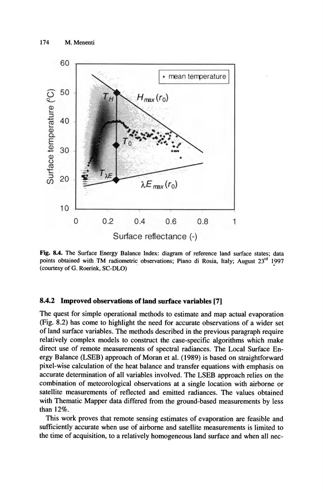
Fig. 8.4. The Surface Energy Balance Index: diagram of reference land surface states; data
points obtained with TM radiometric observations; Piano di Rosia, Italy; August 23'd 1997
(courtesy of G. Roerink, SC-DLO)
.
.
8.4.2 Improved observations of land surface variables [7]
The quest for simple operational methods to estimate and map actual evaporation
(Fig. 8.2) has come to highlight the need for accurate observations of a wider set
of land surface variables. The methods described in the previous paragraph require
relatively complex models to construct the case-specific algorithms which make
direct use of remote measurements of spectral radiances. The Local Surface Energy Balance (LSEB) approach of Moran et al. (1989) is based on straightforward
pixel-wise calculation of the heat balance and transfer equations with emphasis on
accurate determination of all variables involved. The LSEB approach relies on the
combination of meteorological observations at a single location with airborne or
satellite measurements ·of reflected and emitted radiances. The values obtained
with Thematic Mapper data differed from the ground-based measurements by less
than ]2%.
This work proves that remote sensing estimates of evaporation are feasible and
sufficiently accurate when use of airborne and satellite measurements is limited to
the time of acquisition, to a relatively homogeneous land surface and when all nec-
M.Menenti
60
I + rrean terrperature I
..- 50
0
C<..Q)
...
:::J
-- 40 -
('\j
...
Q)
a.
E
Q)
30 .
- Q)
u
('\j
't
:::J
20
(f)
10
o
0.2
0.4
0.6
0.8
1
Surface reflectance (-)
Fig. 8.4. The Surface Energy Balance Index: diagram of reference land surface states; data
points obtained with TM radiometric observations; Piano di Rosia, Italy; August 23'd 1997
(courtesy of G. Roerink, SC-DLO)
.
.
8.4.2 Improved observations of land surface variables [7]
The quest for simple operational methods to estimate and map actual evaporation
(Fig. 8.2) has come to highlight the need for accurate observations of a wider set
of land surface variables. The methods described in the previous paragraph require
relatively complex models to construct the case-specific algorithms which make
direct use of remote measurements of spectral radiances. The Local Surface Energy Balance (LSEB) approach of Moran et al. (1989) is based on straightforward
pixel-wise calculation of the heat balance and transfer equations with emphasis on
accurate determination of all variables involved. The LSEB approach relies on the
combination of meteorological observations at a single location with airborne or
satellite measurements ·of reflected and emitted radiances. The values obtained
with Thematic Mapper data differed from the ground-based measurements by less
than ]2%.
This work proves that remote sensing estimates of evaporation are feasible and
sufficiently accurate when use of airborne and satellite measurements is limited to
the time of acquisition, to a relatively homogeneous land surface and when all nec-