

148
B.G.H. Gorte
probability occurs at the 'right' class also when estimated rather roughly. Even the
most advanced of the methods described above suffers from two drawbacks.
- The probabilistics in Bayes' formula pertain to the entire image, while a decision
is taken for each individual pixel. Having only one set of class a priori probabilities, the class assigned to a pixel depends on the situation in the entire image and
is, therefore, influenced by areas that are far away from the pixel under consideration and have no relation with it.
- The assumption that reflections can be modeled as Normal distributions may be
unrealistic for certain land-use classes, such as built-up and agricultural areas,
which may consist of several land covers with different spectral signatures in
different (unknown) proportions. Also signatures of land-cover classes are influenced by soil type, soil moisture, sun incidence angle (on slopes) etc. and may be
inadequately modeled by Gaussian densities.
Local probabilities. Estimates of the various probabilities can be refined by making them local, i.e. pertaining to parts of the area, instead of to the entire area
(Strahler, 1980, Middelkoop and Janssen, 1991).
If the user is able to subdivide the image into regions, such that different class
mixing proportions occur in each region, and if these mixing proportions are known,
then in each region the expected overall accuracy is higher with a region-specific set
of priors (according to the mixing proportions) than with the' global' set. Therefore,
taking all regions together, the overall accuracy in the entire image also increases.
The necessary subdivision of the image can be made with additional (map) data,
which may be stored, for example, in a geographic information system. The basic
idea is that when deciding upon an class in a particular pixel, statistical data related
to, for example, the soil type in that element are more relevant than statistics for
the entire area. Until now, the objection against this approach was that such detailed
statistics are generally not available. This information can be obtained from the
distribution of reflections.
A posteriori probability values can be used to estimate class areas in an image
region, by interpreting the class posterior probability at a pixel as the pixel's contribution to the total area of that class within its region (Duda and Hart, 1973).
This method was adapted by Gorte and Stein (1998) to estimate class areas in
image subsets. Therefore, the area Ai, covered by class Ci in region r is the sum
over all pixels p in r of the posterior probabilities P (Ci \xp):
Ar = L P(Ci\xp) ,
(7.9)
pEr
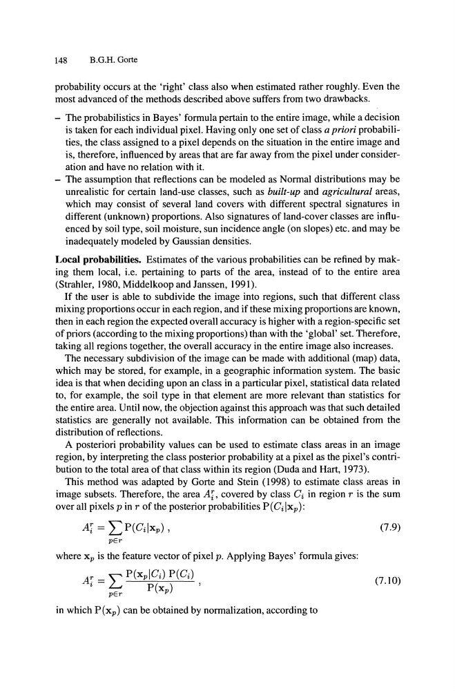
where xp is the feature vector of pixel p. Applying Bayes' formula gives:
(7.10)
in which P(xp) can be obtained by normalization, according to
B.G.H. Gorte
probability occurs at the 'right' class also when estimated rather roughly. Even the
most advanced of the methods described above suffers from two drawbacks.
- The probabilistics in Bayes' formula pertain to the entire image, while a decision
is taken for each individual pixel. Having only one set of class a priori probabilities, the class assigned to a pixel depends on the situation in the entire image and
is, therefore, influenced by areas that are far away from the pixel under consideration and have no relation with it.
- The assumption that reflections can be modeled as Normal distributions may be
unrealistic for certain land-use classes, such as built-up and agricultural areas,
which may consist of several land covers with different spectral signatures in
different (unknown) proportions. Also signatures of land-cover classes are influenced by soil type, soil moisture, sun incidence angle (on slopes) etc. and may be
inadequately modeled by Gaussian densities.
Local probabilities. Estimates of the various probabilities can be refined by making them local, i.e. pertaining to parts of the area, instead of to the entire area
(Strahler, 1980, Middelkoop and Janssen, 1991).
If the user is able to subdivide the image into regions, such that different class
mixing proportions occur in each region, and if these mixing proportions are known,
then in each region the expected overall accuracy is higher with a region-specific set
of priors (according to the mixing proportions) than with the' global' set. Therefore,
taking all regions together, the overall accuracy in the entire image also increases.
The necessary subdivision of the image can be made with additional (map) data,
which may be stored, for example, in a geographic information system. The basic
idea is that when deciding upon an class in a particular pixel, statistical data related
to, for example, the soil type in that element are more relevant than statistics for
the entire area. Until now, the objection against this approach was that such detailed
statistics are generally not available. This information can be obtained from the
distribution of reflections.
A posteriori probability values can be used to estimate class areas in an image
region, by interpreting the class posterior probability at a pixel as the pixel's contribution to the total area of that class within its region (Duda and Hart, 1973).
This method was adapted by Gorte and Stein (1998) to estimate class areas in
image subsets. Therefore, the area Ai, covered by class Ci in region r is the sum
over all pixels p in r of the posterior probabilities P (Ci \xp):
Ar = L P(Ci\xp) ,
(7.9)
pEr
where xp is the feature vector of pixel p. Applying Bayes' formula gives:
(7.10)
in which P(xp) can be obtained by normalization, according to