

7 Land-use and Catchment Characteristics
149
N
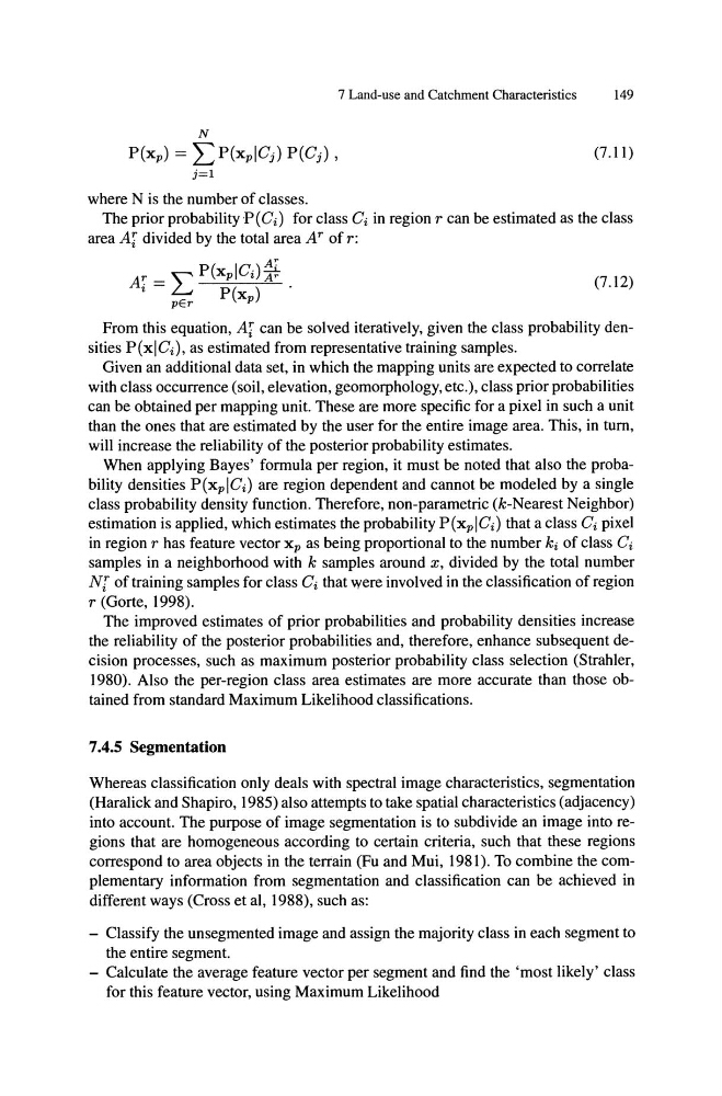
P(Xp) = L P(xp!Cj ) P(Cj ) ,
(7.11)
j=l
where N is the number of classes.
The prior probability P (Ci ) for class Ci in region r can be estimated as the class
area Ai divided by the total area Ar of r:
A:
A~ = L P(Xp!Ci)Tr .
(7.12)
•
pEr
P(xp)
From this equation, Ai can be solved iteratively, given the class probability densities P(x!Ci ), as estimated from representative training samples.
Given an additional data set, in which the mapping units are expected to correlate
with class occurrence (soil, elevation, geomorphology, etc.), class prior probabilities
can be obtained per mapping unit. These are more specific for a pixel in such a unit
than the ones that are estimated by the user for the entire image area. This, in tum,
will increase the reliability of the posterior probability estimates.
When applying Bayes' formula per region, it must be noted that also the probability densities P(xp!Ci ) are region dependent and cannot be modeled by a single
class probability density function. Therefore, non-parametric (k-Nearest Neighbor)
estimation is applied, which estimates the probability P(xp!Ci ) that a class Ci pixel
in region r has feature vector xp as being proportional to the number ki of class Ci
samples in a neighborhood with k samples around x, divided by the total number
N[ of training samples for class Ci that were involved in the classification of region
r (Gorte, 1998).
The improved estimates of prior probabilities and probability densities increase
the reliability of the posterior probabilities and, therefore, enhance subsequent decision processes, such as maximum posterior probability class selection (Strahler,
1980). Also the per-region class area estimates are more accurate than those obtained from standard Maximum Likelihood classifications.
7.4.5 Segmentation
Whereas classification only deals with spectral image characteristics, segmentation
(Haralick and Shapiro, 1985) also attempts to take spatial characteristics (adjacency)
into account. The purpose of image segmentation is to subdivide an image into regions that are homogeneous according to certain criteria, such that these regions
correspond to area objects in the terrain (Fu and Mui, 1981). To combine the complementary information from segmentation and classification can be achieved in
different ways (Cross et aI, 1988), such as:
- Classify the unsegmented image and assign the majority class in each segment to
the entire segment.
- Calculate the average feature vector per segment and find the 'most likely' class
for this feature vector, using Maximum Likelihood
149
N
P(Xp) = L P(xp!Cj ) P(Cj ) ,
(7.11)
j=l
where N is the number of classes.
The prior probability P (Ci ) for class Ci in region r can be estimated as the class
area Ai divided by the total area Ar of r:
A:
A~ = L P(Xp!Ci)Tr .
(7.12)
•
pEr
P(xp)
From this equation, Ai can be solved iteratively, given the class probability densities P(x!Ci ), as estimated from representative training samples.
Given an additional data set, in which the mapping units are expected to correlate
with class occurrence (soil, elevation, geomorphology, etc.), class prior probabilities
can be obtained per mapping unit. These are more specific for a pixel in such a unit
than the ones that are estimated by the user for the entire image area. This, in tum,
will increase the reliability of the posterior probability estimates.
When applying Bayes' formula per region, it must be noted that also the probability densities P(xp!Ci ) are region dependent and cannot be modeled by a single
class probability density function. Therefore, non-parametric (k-Nearest Neighbor)
estimation is applied, which estimates the probability P(xp!Ci ) that a class Ci pixel
in region r has feature vector xp as being proportional to the number ki of class Ci
samples in a neighborhood with k samples around x, divided by the total number
N[ of training samples for class Ci that were involved in the classification of region
r (Gorte, 1998).
The improved estimates of prior probabilities and probability densities increase
the reliability of the posterior probabilities and, therefore, enhance subsequent decision processes, such as maximum posterior probability class selection (Strahler,
1980). Also the per-region class area estimates are more accurate than those obtained from standard Maximum Likelihood classifications.
7.4.5 Segmentation
Whereas classification only deals with spectral image characteristics, segmentation
(Haralick and Shapiro, 1985) also attempts to take spatial characteristics (adjacency)
into account. The purpose of image segmentation is to subdivide an image into regions that are homogeneous according to certain criteria, such that these regions
correspond to area objects in the terrain (Fu and Mui, 1981). To combine the complementary information from segmentation and classification can be achieved in
different ways (Cross et aI, 1988), such as:
- Classify the unsegmented image and assign the majority class in each segment to
the entire segment.
- Calculate the average feature vector per segment and find the 'most likely' class
for this feature vector, using Maximum Likelihood