

Afi r s ti m p r e s s i o n
15
temperature near 0 ◦ C seems to sink downward from Antarctica and then extends
northward along the bottom of the Atlantic (this is the so-called Antarctic Bottom
W aterorAABW).
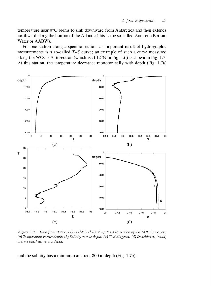
For one station along a specific section, an important result of hydrographic
measurements is a so-called T -S curve; an example of such a curve measured
along the WOCE A16 section (which is at 12 ◦ N in Fig. 1.6) is shown in Fig. 1.7.
At this station, the temperature decreases monotonically with depth (Fig. 1.7a)
0
5
10
15
20
25
30
0
1000
2000
3000
4000
5000
T
depth
(a)
34.6
34.8
35
35.2
35.4
35.6
35.8
36
0
1000
2000
3000
4000
5000
S
depth
(b)
34.6
34.8
35
35.2
35.4
35.6
35.8
36
0
5
10
15
20
25
30
S
T
(c)
27
27.2
27.4
27.6
27.8
28
0
1000
2000
3000
4000
5000
depth
σ σ
σ
σ
t
θ θ
θ
θ
(d)
Figure 1.7. Data from station 129 (12
◦ N, 21
◦ W) along the A16 section of the WOCE program.
(a) Temperature versus depth; (b) Salinity versus depth. (c) T -S diagram. (d) Densities σt (solid)
and σθ (dashed) versus depth.
and the salinity has a minimum at about 800 m depth (Fig. 1.7b).
15
temperature near 0 ◦ C seems to sink downward from Antarctica and then extends
northward along the bottom of the Atlantic (this is the so-called Antarctic Bottom
W aterorAABW).
For one station along a specific section, an important result of hydrographic
measurements is a so-called T -S curve; an example of such a curve measured
along the WOCE A16 section (which is at 12 ◦ N in Fig. 1.6) is shown in Fig. 1.7.
At this station, the temperature decreases monotonically with depth (Fig. 1.7a)
0
5
10
15
20
25
30
0
1000
2000
3000
4000
5000
T
depth
(a)
34.6
34.8
35
35.2
35.4
35.6
35.8
36
0
1000
2000
3000
4000
5000
S
depth
(b)
34.6
34.8
35
35.2
35.4
35.6
35.8
36
0
5
10
15
20
25
30
S
T
(c)
27
27.2
27.4
27.6
27.8
28
0
1000
2000
3000
4000
5000
depth
σ σ
σ
σ
t
θ θ
θ
θ
(d)
Figure 1.7. Data from station 129 (12
◦ N, 21
◦ W) along the A16 section of the WOCE program.
(a) Temperature versus depth; (b) Salinity versus depth. (c) T -S diagram. (d) Densities σt (solid)
and σθ (dashed) versus depth.
and the salinity has a minimum at about 800 m depth (Fig. 1.7b).