

The first region is located in the Dover Strait off the Opal coast of France, where
tidal amplitude can be as high as 9 m and currents can reach 3 m/s. The site is
relatively shallow water with depth less than 50 m. In the middle of the Strait, there
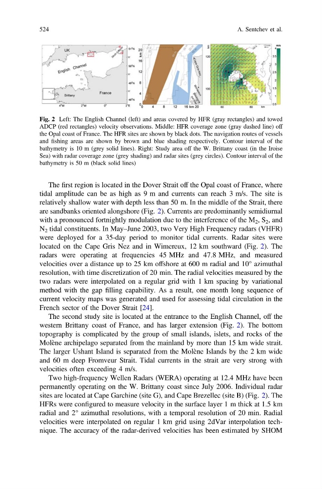
are sandbanks oriented alongshore (Fig. 2). Currents are predominantly semidiurnal
with a pronounced fortnightly modulation due to the interference of the M 2 , S 2 , and
N 2 tidal constituents. In May–June 2003, two Very High Frequency radars (VHFR)
were deployed for a 35-day period to monitor tidal currents. Radar sites were
located on the Cape Gris Nez and in Wimereux, 12 km southward (Fig. 2). The
radars were operating at frequencies 45 MHz and 47.8 MHz, and measured
velocities over a distance up to 25 km offshore at 600 m radial and 10° azimuthal
resolution, with time discretization of 20 min. The radial velocities measured by the
two radars were interpolated on a regular grid with 1 km spacing by variational
method with the gap filling capability. As a result, one month long sequence of
current velocity maps was generated and used for assessing tidal circulation in the
French sector of the Dover Strait [24].
The second study site is located at the entrance to the English Channel, off the
western Brittany coast of France, and has larger extension (Fig. 2). The bottom
topography is complicated by the group of small islands, islets, and rocks of the
Molène archipelago separated from the mainland by more than 15 km wide strait.
The larger Ushant Island is separated from the Molène Islands by the 2 km wide
and 60 m deep Fromveur Strait. Tidal currents in the strait are very strong with
velocities often exceeding 4 m/s.
Two high-frequency Wellen Radars (WERA) operating at 12.4 MHz have been
permanently operating on the W. Brittany coast since July 2006. Individual radar
sites are located at Cape Garchine (site G), and Cape Brezellec (site B) (Fig. 2). The
HFRs were configured to measure velocity in the surface layer 1 m thick at 1.5 km
radial and 2° azimuthal resolutions, with a temporal resolution of 20 min. Radial
velocities were interpolated on regular 1 km grid using 2dVar interpolation technique. The accuracy of the radar-derived velocities has been estimated by SHOM
Fig. 2 Left: The English Channel (left) and areas covered by HFR (gray rectangles) and towed
ADCP (red rectangles) velocity observations. Middle: HFR coverage zone (gray dashed line) off
the Opal coast of France. The HFR sites are shown by black dots. The navigation routes of vessels
and fishing areas are shown by brown and blue shading respectively. Contour interval of the
bathymetry is 10 m (grey solid lines). Right: Study area off the W. Brittany coast (in the Iroise
Sea) with radar coverage zone (grey shading) and radar sites (grey circles). Contour interval of the
bathymetry is 50 m (black solid lines)
524
A. Sentchev et al.
tidal amplitude can be as high as 9 m and currents can reach 3 m/s. The site is
relatively shallow water with depth less than 50 m. In the middle of the Strait, there
are sandbanks oriented alongshore (Fig. 2). Currents are predominantly semidiurnal
with a pronounced fortnightly modulation due to the interference of the M 2 , S 2 , and
N 2 tidal constituents. In May–June 2003, two Very High Frequency radars (VHFR)
were deployed for a 35-day period to monitor tidal currents. Radar sites were
located on the Cape Gris Nez and in Wimereux, 12 km southward (Fig. 2). The
radars were operating at frequencies 45 MHz and 47.8 MHz, and measured
velocities over a distance up to 25 km offshore at 600 m radial and 10° azimuthal
resolution, with time discretization of 20 min. The radial velocities measured by the
two radars were interpolated on a regular grid with 1 km spacing by variational
method with the gap filling capability. As a result, one month long sequence of
current velocity maps was generated and used for assessing tidal circulation in the
French sector of the Dover Strait [24].
The second study site is located at the entrance to the English Channel, off the
western Brittany coast of France, and has larger extension (Fig. 2). The bottom
topography is complicated by the group of small islands, islets, and rocks of the
Molène archipelago separated from the mainland by more than 15 km wide strait.
The larger Ushant Island is separated from the Molène Islands by the 2 km wide
and 60 m deep Fromveur Strait. Tidal currents in the strait are very strong with
velocities often exceeding 4 m/s.
Two high-frequency Wellen Radars (WERA) operating at 12.4 MHz have been
permanently operating on the W. Brittany coast since July 2006. Individual radar
sites are located at Cape Garchine (site G), and Cape Brezellec (site B) (Fig. 2). The
HFRs were configured to measure velocity in the surface layer 1 m thick at 1.5 km
radial and 2° azimuthal resolutions, with a temporal resolution of 20 min. Radial
velocities were interpolated on regular 1 km grid using 2dVar interpolation technique. The accuracy of the radar-derived velocities has been estimated by SHOM
Fig. 2 Left: The English Channel (left) and areas covered by HFR (gray rectangles) and towed
ADCP (red rectangles) velocity observations. Middle: HFR coverage zone (gray dashed line) off
the Opal coast of France. The HFR sites are shown by black dots. The navigation routes of vessels
and fishing areas are shown by brown and blue shading respectively. Contour interval of the
bathymetry is 10 m (grey solid lines). Right: Study area off the W. Brittany coast (in the Iroise
Sea) with radar coverage zone (grey shading) and radar sites (grey circles). Contour interval of the
bathymetry is 50 m (black solid lines)
524
A. Sentchev et al.