

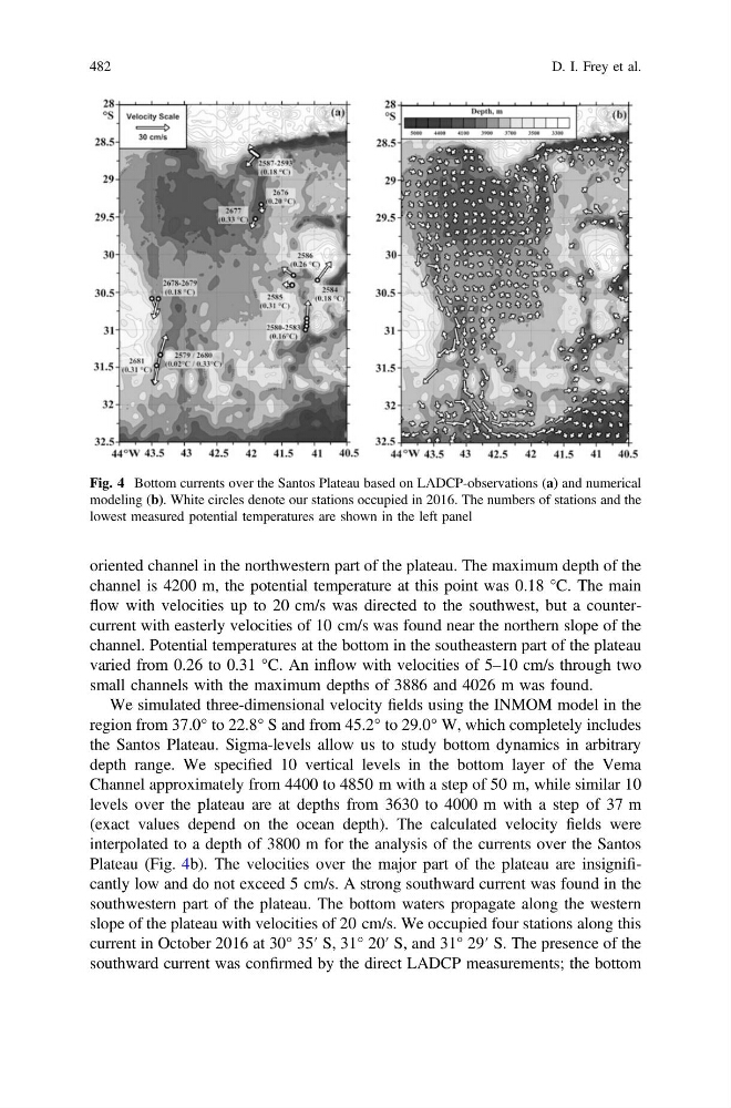
oriented channel in the northwestern part of the plateau. The maximum depth of the
channel is 4200 m, the potential temperature at this point was 0.18 °C. The main
flow with velocities up to 20 cm/s was directed to the southwest, but a countercurrent with easterly velocities of 10 cm/s was found near the northern slope of the
channel. Potential temperatures at the bottom in the southeastern part of the plateau
varied from 0.26 to 0.31 °C. An inflow with velocities of 5–10 cm/s through two
small channels with the maximum depths of 3886 and 4026 m was found.
We simulated three-dimensional velocity fields using the INMOM model in the
region from 37.0° to 22.8° S and from 45.2° to 29.0° W, which completely includes
the Santos Plateau. Sigma-levels allow us to study bottom dynamics in arbitrary
depth range. We specified 10 vertical levels in the bottom layer of the Vema
Channel approximately from 4400 to 4850 m with a step of 50 m, while similar 10
levels over the plateau are at depths from 3630 to 4000 m with a step of 37 m
(exact values depend on the ocean depth). The calculated velocity fields were
interpolated to a depth of 3800 m for the analysis of the currents over the Santos
Plateau (Fig. 4b). The velocities over the major part of the plateau are insignificantly low and do not exceed 5 cm/s. A strong southward current was found in the
southwestern part of the plateau. The bottom waters propagate along the western
slope of the plateau with velocities of 20 cm/s. We occupied four stations along this
current in October 2016 at 30° 35′ S, 31° 20′ S, and 31° 29′ S. The presence of the
southward current was confirmed by the direct LADCP measurements; the bottom
Fig. 4 Bottom currents over the Santos Plateau based on LADCP-observations (a) and numerical
modeling (b). White circles denote our stations occupied in 2016. The numbers of stations and the
lowest measured potential temperatures are shown in the left panel
482
D. I. Frey et al.
channel is 4200 m, the potential temperature at this point was 0.18 °C. The main
flow with velocities up to 20 cm/s was directed to the southwest, but a countercurrent with easterly velocities of 10 cm/s was found near the northern slope of the
channel. Potential temperatures at the bottom in the southeastern part of the plateau
varied from 0.26 to 0.31 °C. An inflow with velocities of 5–10 cm/s through two
small channels with the maximum depths of 3886 and 4026 m was found.
We simulated three-dimensional velocity fields using the INMOM model in the
region from 37.0° to 22.8° S and from 45.2° to 29.0° W, which completely includes
the Santos Plateau. Sigma-levels allow us to study bottom dynamics in arbitrary
depth range. We specified 10 vertical levels in the bottom layer of the Vema
Channel approximately from 4400 to 4850 m with a step of 50 m, while similar 10
levels over the plateau are at depths from 3630 to 4000 m with a step of 37 m
(exact values depend on the ocean depth). The calculated velocity fields were
interpolated to a depth of 3800 m for the analysis of the currents over the Santos
Plateau (Fig. 4b). The velocities over the major part of the plateau are insignificantly low and do not exceed 5 cm/s. A strong southward current was found in the
southwestern part of the plateau. The bottom waters propagate along the western
slope of the plateau with velocities of 20 cm/s. We occupied four stations along this
current in October 2016 at 30° 35′ S, 31° 20′ S, and 31° 29′ S. The presence of the
southward current was confirmed by the direct LADCP measurements; the bottom
Fig. 4 Bottom currents over the Santos Plateau based on LADCP-observations (a) and numerical
modeling (b). White circles denote our stations occupied in 2016. The numbers of stations and the
lowest measured potential temperatures are shown in the left panel
482
D. I. Frey et al.