

gradually slowing down. The minimum potential temperature observed at stations
2436–2438 was −0.08 °C. Hence, the difference between the minimum temperature
at the beginning and at the end of the Vema Channel is 0.05 °C. In 2003, we
performed CTD-measurements along the channel, and the corresponding difference
was 0.04 °C. Therefore, the mean gradient of the bottom temperature in the channel
is less than 0.01 °C/100 km.
Currents over the Santos Plateau
The Santos Plateau is located to the west of the Vema Channel at 28–32° S and
40–44° W. The depths of the major part of the plateau are approximately 4 km.
According to the measurements, the potential temperature isotherm θ = 2 °C is
located at a depth of 3300–3400 m; hence, the Antarctic Bottom Water layer above
the plateau is 600–700 m thick. Numerous small channels are located along the
southern and eastern edges of the plateau. The mean depths of these channels
relative to the surrounding plateau are 200–300 m.
In April–May and October–November 2016, we carried out two expeditions
onboard the R/V “Akademik Sergey Vavilov” studying the bottom currents over
the Santos Plateau. Twenty one stations with CTD and LADCP measurements were
occupied in the small channels over the plateau. The locations of these stations,
bottom potential temperatures, and maximum velocities in the bottom layer are
shown in Fig. 4a. A section of seven stations was occupied across the zonally
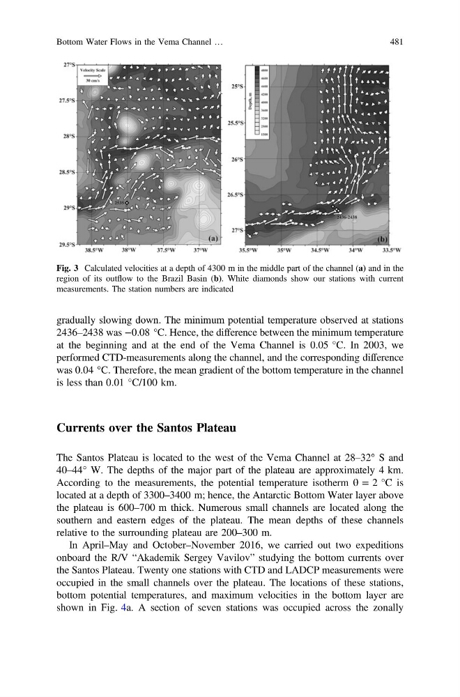
Fig. 3 Calculated velocities at a depth of 4300 m in the middle part of the channel (a) and in the
region of its outflow to the Brazil Basin (b). White diamonds show our stations with current
measurements. The station numbers are indicated
Bottom Water Flows in the Vema Channel …
481
2436–2438 was −0.08 °C. Hence, the difference between the minimum temperature
at the beginning and at the end of the Vema Channel is 0.05 °C. In 2003, we
performed CTD-measurements along the channel, and the corresponding difference
was 0.04 °C. Therefore, the mean gradient of the bottom temperature in the channel
is less than 0.01 °C/100 km.
Currents over the Santos Plateau
The Santos Plateau is located to the west of the Vema Channel at 28–32° S and
40–44° W. The depths of the major part of the plateau are approximately 4 km.
According to the measurements, the potential temperature isotherm θ = 2 °C is
located at a depth of 3300–3400 m; hence, the Antarctic Bottom Water layer above
the plateau is 600–700 m thick. Numerous small channels are located along the
southern and eastern edges of the plateau. The mean depths of these channels
relative to the surrounding plateau are 200–300 m.
In April–May and October–November 2016, we carried out two expeditions
onboard the R/V “Akademik Sergey Vavilov” studying the bottom currents over
the Santos Plateau. Twenty one stations with CTD and LADCP measurements were
occupied in the small channels over the plateau. The locations of these stations,
bottom potential temperatures, and maximum velocities in the bottom layer are
shown in Fig. 4a. A section of seven stations was occupied across the zonally
Fig. 3 Calculated velocities at a depth of 4300 m in the middle part of the channel (a) and in the
region of its outflow to the Brazil Basin (b). White diamonds show our stations with current
measurements. The station numbers are indicated
Bottom Water Flows in the Vema Channel …
481