

154
L. R. M. Maas et al.
Table 3 Summary of the ADCPs deployed off South-East Madagascar during the INATEX
project. See Fig. 2 for details
Mooring site Position
Inst. mean
depth (m)
Local depth
(m)
Total days
Dates
mm/dd/yy
EMC1
22 ◦ 41.879 S
48 ◦ 1.006 E
500
504
909
10/06/10–
04/02/13
EMC2
22 ◦ 43.484 S
48 ◦ 8.013 E
500
1603
924
10/06/10–
04/17/13
EMC3
22
◦
46.950 S
48
◦
22.860 E
2600
2654
924
10/06/10–
04/17/13
EMC4
22
◦
48.689 S
48 ◦ 30.827 E
500
3799
924
10/06/10–
04/17/13
EMC5
22 ◦ 55.483 S
49 ◦ 0.435 E
500
3959
924
10/05/10–
04/16/13
02/08
03/08
04/08
05/08
06/08
07/08
08/08
09/08
10/08
11/08
12/08
01/09
−40
−30
−20
−10
0
10
Displ. (m)
lmc5 – 617m ( 1375 mab)
02/08
03/08
04/08
05/08
06/08
07/08
08/08
09/08
10/08
11/08
12/08
01/09
−4
−2
0
2
4
Displ. (m)
02/08
03/08
04/08
05/08
06/08
07/08
08/08
09/08
10/08
11/08
12/08
01/09
−4
−2
0
2
4
Displ. (m)
02/08
03/08
04/08
05/08
06/08
07/08
08/08
09/08
10/08
11/08
12/08
01/09
−4
−2
0
2
4
Displ. (m)
Raw Data
Maske d Data
HP F ilte re d Data
Residual
Surf ac e T idal Pre dic tion
(a)
(b)
(c)
(d)
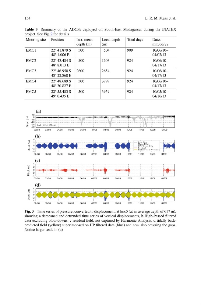
Fig. 3 Time series of pressure, converted to displacement, at lmc5 (at an average depth of 617 m),
showing a demeaned and detrended time series of vertical displacements, b High-Passed filtered
data excluding blow-downs, c residual field, not captured by Harmonic Analysis, d tidally backpredicted field (yellow) superimposed on HP filtered data (blue) and now also covering the gaps.
Notice larger scale in (a)
L. R. M. Maas et al.
Table 3 Summary of the ADCPs deployed off South-East Madagascar during the INATEX
project. See Fig. 2 for details
Mooring site Position
Inst. mean
depth (m)
Local depth
(m)
Total days
Dates
mm/dd/yy
EMC1
22 ◦ 41.879 S
48 ◦ 1.006 E
500
504
909
10/06/10–
04/02/13
EMC2
22 ◦ 43.484 S
48 ◦ 8.013 E
500
1603
924
10/06/10–
04/17/13
EMC3
22
◦
46.950 S
48
◦
22.860 E
2600
2654
924
10/06/10–
04/17/13
EMC4
22
◦
48.689 S
48 ◦ 30.827 E
500
3799
924
10/06/10–
04/17/13
EMC5
22 ◦ 55.483 S
49 ◦ 0.435 E
500
3959
924
10/05/10–
04/16/13
02/08
03/08
04/08
05/08
06/08
07/08
08/08
09/08
10/08
11/08
12/08
01/09
−40
−30
−20
−10
0
10
Displ. (m)
lmc5 – 617m ( 1375 mab)
02/08
03/08
04/08
05/08
06/08
07/08
08/08
09/08
10/08
11/08
12/08
01/09
−4
−2
0
2
4
Displ. (m)
02/08
03/08
04/08
05/08
06/08
07/08
08/08
09/08
10/08
11/08
12/08
01/09
−4
−2
0
2
4
Displ. (m)
02/08
03/08
04/08
05/08
06/08
07/08
08/08
09/08
10/08
11/08
12/08
01/09
−4
−2
0
2
4
Displ. (m)
Raw Data
Maske d Data
HP F ilte re d Data
Residual
Surf ac e T idal Pre dic tion
(a)
(b)
(c)
(d)
Fig. 3 Time series of pressure, converted to displacement, at lmc5 (at an average depth of 617 m),
showing a demeaned and detrended time series of vertical displacements, b High-Passed filtered
data excluding blow-downs, c residual field, not captured by Harmonic Analysis, d tidally backpredicted field (yellow) superimposed on HP filtered data (blue) and now also covering the gaps.
Notice larger scale in (a)