

Part C | 30.3
674 Part C Coastal Design
tal, loss of life, etc. when using the risk equation in
coastal engineering design. The final choice for the
selected design should consider all the possible consequences of damage and the potential failure of the
selected design. The one with the lowest risk should be
selected for construction.
30.3 Shoreline Stabilization Structures
Coasts with marine deposits (barrier islands and sandy
beaches) are one of the most widely found geomorphic
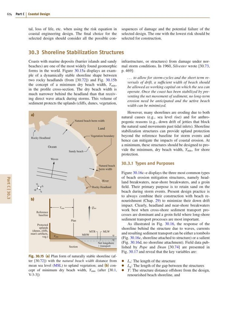
forms in the world. Figure 30.15a displays an example of a dynamically stable shoreline shape between
two rocky headlands (from [30.72]) and Fig. 30.15b
the concept of a minimum dry beach width, Y min ,
in the profile cross-section. The dry beach width is
much narrower behind the headland than that receiving direct wave attack during storms. This volume of
sediment protects the uplands (cliffs, dunes, vegetation,
a)
b)
Natural beach berm width
Natural beach
berm width
Sandy beach
Vegetation boundary
Land
Ocean
Rocky Headland
Rocky Headland
Reference
baseline
Protected
uplands
(dunes, cliffs,
man′s artifacts,
veg.)
Section
Plan
MHW
MTR
MLW
Net longshore
+ transport
Q net
Y min
V min
River
Waves
E
N
S
W
Fig. 30.15 (a) Plan form of naturally stable shoreline (after [30.72]) with the natural beach width distance from
mean sea level (MSL) to upland vegetation; and (b) concept of minimum dry beach width, Y min (after [30.1,
V-3-3])
infrastructure, or structures) from damage under normal storm conditions. In 1960, Silvester wrote [30.73,
p. 469]:
. . . to allow for storm-cycles and the short term reversals of drift, a sufficient width of beach should
be allowed as working capital on which the sea can
operate. Once the coast has been stabilized by preventing the net movement of sediment, no long-term
erosion need be anticipated and the active beach
width can be minimized.
However, many shorelines are eroding due to both
natural causes (e.g., sea level rise) and for anthropogenic reasons (e.g., down drift of jetties that block
the natural sand movements past tidal inlets). Shoreline
stabilization structures can provide upland protection
beyond the reference baseline for storm events and
hence can mitigate the impacts of coastal erosion. At
a minimum, these structures should be designed to provide the minimum, dry beach width, Y min , for shore
protection.
30.3.1 Types and Purposes
Figure 30.16c–e displays the three most common types
of beach erosion mitigation structures, namely headland breakwaters, near-shore breakwaters, and a groin
field. Their primary purpose is to retain sand on the
beach during storm events. Present design practice is
to always combine their construction with beach renourishment (Chap. 29) to minimize their down drift
impact. Clearly, headland and near-shore breakwaters
work best when cross-shore sediment transport processes are dominant and a groin field where long-shore
sediment transport processes are most important.
As illustrated in Fig. 30.16, the response of the
shoreline behind the structure due to waves, currents
and resulting sediment transport can be either a tombolo
(Fig. 30.16c, shoreline attached to structure) or a salient
(Fig. 30.16d, no shoreline attachment). Field data published by Pope and Dean [30.74] are presented in
Fig. 30.17 and reveal that the key variables are:
L s : The length of the structure
L g : The length of the gap between the structures
Y: The structure distance offshore from the design,
renourished beach shoreline, and