

Part C | 29.6
646 Part C Coastal Design
Santa Monica mountains
Topanga
Canyon
Will Rogers Beach
Santa Monica Beach
Santa Monica
Breakwater
& Pier
Marina del Ray
Breakwater
King Harbor
Breakwater
Topaz St. Groin
Malaga Cove
Chevron Groin
R ed on do
su bm ar in e
ca ny on
Marina del Ray
Venice Breakwater
Venice Beach
Dockweiler Beach
Manhattan Beach
Hermosa Beach
Redondo Beach
Palos Verdes Point
Ballona creek
Santa Monica Bay
Santa Monica
Bay
Southern California
Bight
Southern
California
Los Angeles
Dana point
San Diego
Point Loma
North
North
Point conception
0
1
2
Scale in miles
3
4
5
Channel Islands
Santa Catalina
Island
Point Dume
Fig. 29.14 Santa Monica Bay. General
Area of Interest (after [29.21])
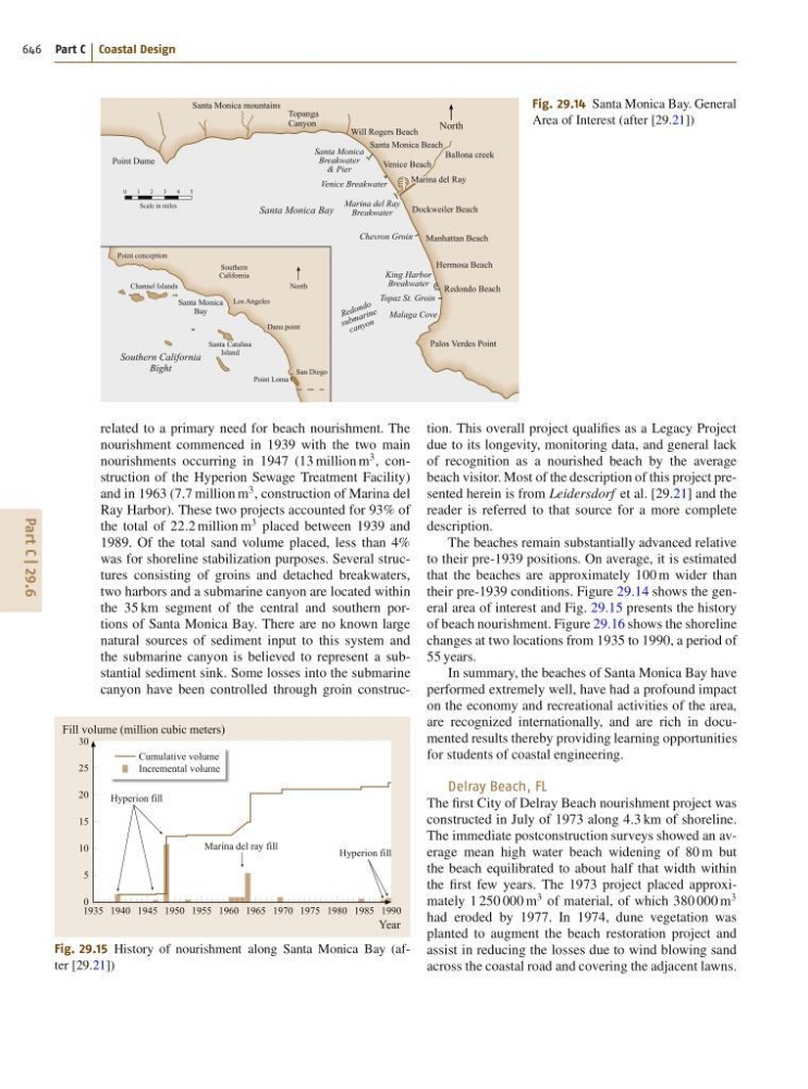
related to a primary need for beach nourishment. The
nourishment commenced in 1939 with the two main
nourishments occurring in 1947 (13 million m
3 , construction of the Hyperion Sewage Treatment Facility)
and in 1963 (7:7 million m
3 , construction of Marina del
Ray Harbor). These two projects accounted for 93% of
the total of 22:2 million m
3 placed between 1939 and
1989. Of the total sand volume placed, less than 4%
was for shoreline stabilization purposes. Several structures consisting of groins and detached breakwaters,
two harbors and a submarine canyon are located within
the 35 km segment of the central and southern portions of Santa Monica Bay. There are no known large
natural sources of sediment input to this system and
the submarine canyon is believed to represent a substantial sediment sink. Some losses into the submarine
canyon have been controlled through groin construcCumulative volume
Incremental volume
1935 1940 1945 1950 1955 1960 1965 1970 1975 1980 1985 1990
Marina del ray fill
Hyperion fill
Hyperion fill
Fill volume (million cubic meters)
Year
30
25
20
15
10
5
0
Fig. 29.15 History of nourishment along Santa Monica Bay (after [29.21])
tion. This overall project qualifies as a Legacy Project
due to its longevity, monitoring data, and general lack
of recognition as a nourished beach by the average
beach visitor. Most of the description of this project presented herein is from Leidersdorf et al. [29.21] and the
reader is referred to that source for a more complete
description.
The beaches remain substantially advanced relative
to their pre-1939 positions. On average, it is estimated
that the beaches are approximately 100 m wider than
their pre-1939 conditions. Figure 29.14 shows the general area of interest and Fig. 29.15 presents the history
of beach nourishment. Figure 29.16 shows the shoreline
changes at two locations from 1935 to 1990, a period of
55 years.
In summary, the beaches of Santa Monica Bay have
performed extremely well, have had a profound impact
on the economy and recreational activities of the area,
are recognized internationally, and are rich in documented results thereby providing learning opportunities
for students of coastal engineering.
Delray Beach, FL
The first City of Delray Beach nourishment project was
constructed in July of 1973 along 4:3 km of shoreline.
The immediate postconstruction surveys showed an average mean high water beach widening of 80 m but
the beach equilibrated to about half that width within
the first few years. The 1973 project placed approximately 1 250 000 m
3 of material, of which 380 000 m
3
had eroded by 1977. In 1974, dune vegetation was
planted to augment the beach restoration project and
assist in reducing the losses due to wind blowing sand
across the coastal road and covering the adjacent lawns.