

Part A | 2.5
30 Part A Fundamentals
Outflow
Eye
Descending
air
S p i r a l r a in b an ds
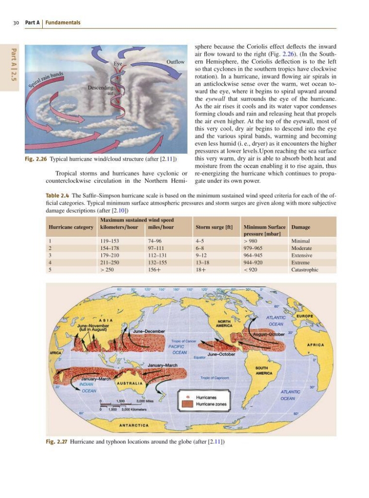
Fig. 2.26 Typical hurricane wind/cloud structure (after [2.11])
Tropical storms and hurricanes have cyclonic or
counterclockwise circulation in the Northern HemiTable 2.4 The Saffir–Simpson hurricane scale is based on the minimum sustained wind speed criteria for each of the official categories. Typical minimum surface atmospheric pressures and storm surges are given along with more subjective
damage descriptions (after [2.10])
Maximum sustained wind speed
Hurricane category kilometers=hour
miles=hour
Storm surge [ft]
Minimum Surface
pressure [mbar]
Damage
1
119–153
74–96
4–5
> 980
Minimal
2
154–178
97–111
6–8
979–965
Moderate
3
179–210
112–131
9–12
964–945
Extensive
4
211–250
132–155
13–18
944–920
Extreme
5
> 250
156C
18C
< 920
Catastrophic
Fig. 2.27 Hurricane and typhoon locations around the globe (after [2.11])
sphere because the Coriolis effect deflects the inward
air flow toward to the right (Fig. 2.26). (In the Southern Hemisphere, the Coriolis deflection is to the left
so that cyclones in the southern tropics have clockwise
rotation). In a hurricane, inward flowing air spirals in
an anticlockwise sense over the warm, wet ocean toward the eye, where it begins to spiral upward around
the eyewall that surrounds the eye of the hurricane.
As the air rises it cools and its water vapor condenses
forming clouds and rain and releasing heat that propels
the air even higher. At the top of the eyewall, most of
this very cool, dry air begins to descend into the eye
and the various spiral bands, warming and becoming
even less humid (i. e., dryer) as it encounters the higher
pressures at lower levels.Upon reaching the sea surface
this very warm, dry air is able to absorb both heat and
moisture from the ocean enabling it to rise again, thus
re-energizing the hurricane which continues to propagate under its own power.
30 Part A Fundamentals
Outflow
Eye
Descending
air
S p i r a l r a in b an ds
Fig. 2.26 Typical hurricane wind/cloud structure (after [2.11])
Tropical storms and hurricanes have cyclonic or
counterclockwise circulation in the Northern HemiTable 2.4 The Saffir–Simpson hurricane scale is based on the minimum sustained wind speed criteria for each of the official categories. Typical minimum surface atmospheric pressures and storm surges are given along with more subjective
damage descriptions (after [2.10])
Maximum sustained wind speed
Hurricane category kilometers=hour
miles=hour
Storm surge [ft]
Minimum Surface
pressure [mbar]
Damage
1
119–153
74–96
4–5
> 980
Minimal
2
154–178
97–111
6–8
979–965
Moderate
3
179–210
112–131
9–12
964–945
Extensive
4
211–250
132–155
13–18
944–920
Extreme
5
> 250
156C
18C
< 920
Catastrophic
Fig. 2.27 Hurricane and typhoon locations around the globe (after [2.11])
sphere because the Coriolis effect deflects the inward
air flow toward to the right (Fig. 2.26). (In the Southern Hemisphere, the Coriolis deflection is to the left
so that cyclones in the southern tropics have clockwise
rotation). In a hurricane, inward flowing air spirals in
an anticlockwise sense over the warm, wet ocean toward the eye, where it begins to spiral upward around
the eyewall that surrounds the eye of the hurricane.
As the air rises it cools and its water vapor condenses
forming clouds and rain and releasing heat that propels
the air even higher. At the top of the eyewall, most of
this very cool, dry air begins to descend into the eye
and the various spiral bands, warming and becoming
even less humid (i. e., dryer) as it encounters the higher
pressures at lower levels.Upon reaching the sea surface
this very warm, dry air is able to absorb both heat and
moisture from the ocean enabling it to rise again, thus
re-energizing the hurricane which continues to propagate under its own power.