

Part B | 20.6
470 Part B Autonomous Ocean Vehicles, Subsystems and Control
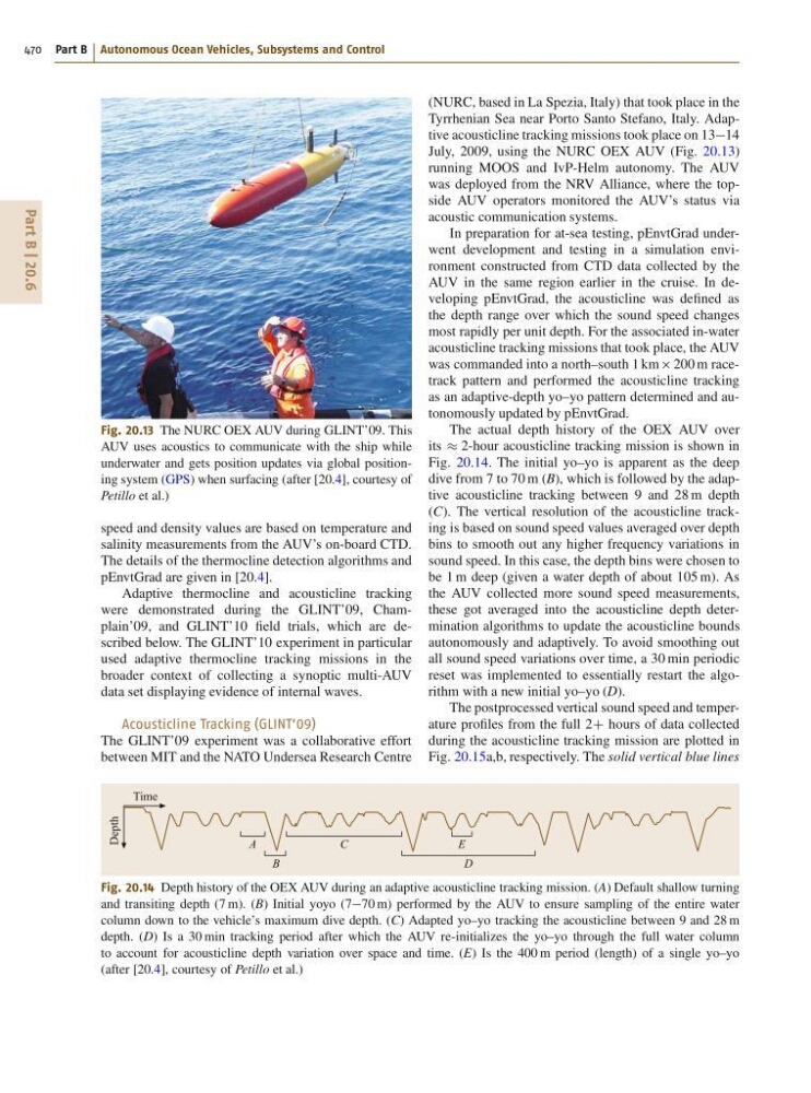
Fig. 20.13 The NURC OEX AUV during GLINT’09. This
AUV uses acoustics to communicate with the ship while
underwater and gets position updates via global positioning system (GPS) when surfacing (after [20.4], courtesy of
Petillo et al.)
speed and density values are based on temperature and
salinity measurements from the AUV’s on-board CTD.
The details of the thermocline detection algorithms and
pEnvtGrad are given in [20.4].
Adaptive thermocline and acousticline tracking
were demonstrated during the GLINT’09, Champlain’09, and GLINT’10 field trials, which are described below. The GLINT’10 experiment in particular
used adaptive thermocline tracking missions in the
broader context of collecting a synoptic multi-AUV
data set displaying evidence of internal waves.
Acousticline Tracking (GLINT’09)
The GLINT’09 experiment was a collaborative effort
between MIT and the NATO Undersea Research Centre
B
A
D
E
C
Time
Depth
Fig. 20.14 Depth history of the OEX AUV during an adaptive acousticline tracking mission. (A) Default shallow turning
and transiting depth (7 m). (B) Initial yoyo (770 m) performed by the AUV to ensure sampling of the entire water
column down to the vehicle’s maximum dive depth. (C) Adapted yo–yo tracking the acousticline between 9 and 28 m
depth. (D) Is a 30 min tracking period after which the AUV re-initializes the yo–yo through the full water column
to account for acousticline depth variation over space and time. (E) Is the 400 m period (length) of a single yo–yo
(after [20.4], courtesy of Petillo et al.)
(NURC, based in La Spezia, Italy) that took place in the
Tyrrhenian Sea near Porto Santo Stefano, Italy. Adaptive acousticline tracking missions took place on 1314
July, 2009, using the NURC OEX AUV (Fig. 20.13)
running MOOS and IvP-Helm autonomy. The AUV
was deployed from the NRV Alliance, where the topside AUV operators monitored the AUV’s status via
acoustic communication systems.
In preparation for at-sea testing, pEnvtGrad underwent development and testing in a simulation environment constructed from CTD data collected by the
AUV in the same region earlier in the cruise. In developing pEnvtGrad, the acousticline was defined as
the depth range over which the sound speed changes
most rapidly per unit depth. For the associated in-water
acousticline tracking missions that took place, the AUV
was commanded into a north–south 1 km 200 m racetrack pattern and performed the acousticline tracking
as an adaptive-depth yo–yo pattern determined and autonomously updated by pEnvtGrad.
The actual depth history of the OEX AUV over
its 2-hour acousticline tracking mission is shown in
Fig. 20.14. The initial yo–yo is apparent as the deep
dive from 7 to 70 m (B), which is followed by the adaptive acousticline tracking between 9 and 28 m depth
(C). The vertical resolution of the acousticline tracking is based on sound speed values averaged over depth
bins to smooth out any higher frequency variations in
sound speed. In this case, the depth bins were chosen to
be 1 m deep (given a water depth of about 105 m). As
the AUV collected more sound speed measurements,
these got averaged into the acousticline depth determination algorithms to update the acousticline bounds
autonomously and adaptively. To avoid smoothing out
all sound speed variations over time, a 30 min periodic
reset was implemented to essentially restart the algorithm with a new initial yo–yo (D).
The postprocessed vertical sound speed and temperature profiles from the full 2C hours of data collected
during the acousticline tracking mission are plotted in
Fig. 20.15a,b, respectively. The solid vertical blue lines
470 Part B Autonomous Ocean Vehicles, Subsystems and Control
Fig. 20.13 The NURC OEX AUV during GLINT’09. This
AUV uses acoustics to communicate with the ship while
underwater and gets position updates via global positioning system (GPS) when surfacing (after [20.4], courtesy of
Petillo et al.)
speed and density values are based on temperature and
salinity measurements from the AUV’s on-board CTD.
The details of the thermocline detection algorithms and
pEnvtGrad are given in [20.4].
Adaptive thermocline and acousticline tracking
were demonstrated during the GLINT’09, Champlain’09, and GLINT’10 field trials, which are described below. The GLINT’10 experiment in particular
used adaptive thermocline tracking missions in the
broader context of collecting a synoptic multi-AUV
data set displaying evidence of internal waves.
Acousticline Tracking (GLINT’09)
The GLINT’09 experiment was a collaborative effort
between MIT and the NATO Undersea Research Centre
B
A
D
E
C
Time
Depth
Fig. 20.14 Depth history of the OEX AUV during an adaptive acousticline tracking mission. (A) Default shallow turning
and transiting depth (7 m). (B) Initial yoyo (770 m) performed by the AUV to ensure sampling of the entire water
column down to the vehicle’s maximum dive depth. (C) Adapted yo–yo tracking the acousticline between 9 and 28 m
depth. (D) Is a 30 min tracking period after which the AUV re-initializes the yo–yo through the full water column
to account for acousticline depth variation over space and time. (E) Is the 400 m period (length) of a single yo–yo
(after [20.4], courtesy of Petillo et al.)
(NURC, based in La Spezia, Italy) that took place in the
Tyrrhenian Sea near Porto Santo Stefano, Italy. Adaptive acousticline tracking missions took place on 1314
July, 2009, using the NURC OEX AUV (Fig. 20.13)
running MOOS and IvP-Helm autonomy. The AUV
was deployed from the NRV Alliance, where the topside AUV operators monitored the AUV’s status via
acoustic communication systems.
In preparation for at-sea testing, pEnvtGrad underwent development and testing in a simulation environment constructed from CTD data collected by the
AUV in the same region earlier in the cruise. In developing pEnvtGrad, the acousticline was defined as
the depth range over which the sound speed changes
most rapidly per unit depth. For the associated in-water
acousticline tracking missions that took place, the AUV
was commanded into a north–south 1 km 200 m racetrack pattern and performed the acousticline tracking
as an adaptive-depth yo–yo pattern determined and autonomously updated by pEnvtGrad.
The actual depth history of the OEX AUV over
its 2-hour acousticline tracking mission is shown in
Fig. 20.14. The initial yo–yo is apparent as the deep
dive from 7 to 70 m (B), which is followed by the adaptive acousticline tracking between 9 and 28 m depth
(C). The vertical resolution of the acousticline tracking is based on sound speed values averaged over depth
bins to smooth out any higher frequency variations in
sound speed. In this case, the depth bins were chosen to
be 1 m deep (given a water depth of about 105 m). As
the AUV collected more sound speed measurements,
these got averaged into the acousticline depth determination algorithms to update the acousticline bounds
autonomously and adaptively. To avoid smoothing out
all sound speed variations over time, a 30 min periodic
reset was implemented to essentially restart the algorithm with a new initial yo–yo (D).
The postprocessed vertical sound speed and temperature profiles from the full 2C hours of data collected
during the acousticline tracking mission are plotted in
Fig. 20.15a,b, respectively. The solid vertical blue lines