

Underwater Vehicle Manipulators 17.6 Underwater AutonomousManipulation 417
Part B | 17.6
Each phase was executed with no human intervention. The following information was known in advance
and given to the SAUVIM computer:
1. Shape of the platform
2. Shape of the target to recover
3. Search area for the platform
4. Directional information about the target’s location
on the platform (frontal area of the platform).
17.6.1 Phase 1: Undock from the Pier
and Navigate to a Search Area
The surface navigation, in this undocking phase, was
aided by the differential global positioning system
(DGPS), with an accuracy of about 23 m. This accuracy is sufficient enough for SAUVIM to move to
a target area where to begin the search for the platform
(Fig. 17.6). After detecting the platform by the scanning sonar, SAUVIM aligned itself to the platform and
became ready to dive toward it.
17.6.2 Phase 2: Search
for the Submerged Platform
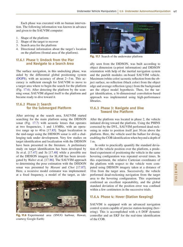
After arriving at the search area, SAUVIM started
searching for the main platform using the DIDSON
sonar (Fig. 17.7) with acoustic lenses that operates
at two frequencies, 1 and 1:8 MHz, with an operative range up to 40 m [17.85]. Target localization in
the mid-range using the DIDSON sonar is still a challenging task under development. Very few studies on
target identification and localization with the DIDSON
have been presented in the literature. A preliminary
study on target identification has been developed by
Yu et al. [17.47] and Yu [17.48] while a possible use
of the DIDSON imagery for SLAM has been investigated by Walter et al. [17.86]. The SAUVIM approach
to determining the pose estimation with the DISDON
sonar was presented by Marani and Choi [17.87].
Here, a recursive model estimator was implemented:
at a fixed frequency, a model of the target, as ideFig. 17.6 Experimental area (SNUG harbour, Hawaii,
courtesy Google Earth)
Fig. 17.7 Search of the underwater platform
ally seen from the DIDSON, was built according to
object dimension (a-priori information) and DIDSON
orientation with help of the inertial navigation system
and the pan/tilt modules on-board SAUVIM vehicle.
Maximum (white color) acoustic reflection from the object surface, no reflection (black color) from the object
edge and average reflection (gray) from the background
are the object model hypothesis. Then, for the target identification, a bi-dimensional convolution-based
approach was implemented using high-performance
libraries.
17.6.3 Phase 3: Navigate and Dive
Toward the Platform
After the platform was located in phase 2, the vehicle
initiated diving toward the platform. Using the PHINS
corrected by the DVL, SAUVIM performed dead reckoning in order to position itself just 30 cm above the
platform. Here, the vehicle used the ballast for diving,
enabling the COB identification when beyond a depth of
1 m.
In order to practically quantify the standard deviation of the vehicle position over the platform, a predefined experiment of positioning the vehicle in the same
hovering configuration was repeated several times. In
this experiment, the relative Cartesian coordinates of
the platform with respect to the vehicle were computed using DIDSON imagery taken at a distance of
10 m from the target area. Successively, the vehicle
performed dead-reckoning navigation from the target
area to the hovering configuration. This experiment
confirmed an excellent repeatability, and the global
standard deviation of the position error was confined
within a few centimeters in the successive trials.
17.6.4 Phase 4: Hover (Station Keeping)
SAUVIM is equipped with an advanced navigation
control system capable of precise station-keeping (hovering). This is accomplished with a 6 DOF dynamic
controller and an EKF for the real-time identification
of the COB.
Part B | 17.6
Each phase was executed with no human intervention. The following information was known in advance
and given to the SAUVIM computer:
1. Shape of the platform
2. Shape of the target to recover
3. Search area for the platform
4. Directional information about the target’s location
on the platform (frontal area of the platform).
17.6.1 Phase 1: Undock from the Pier
and Navigate to a Search Area
The surface navigation, in this undocking phase, was
aided by the differential global positioning system
(DGPS), with an accuracy of about 23 m. This accuracy is sufficient enough for SAUVIM to move to
a target area where to begin the search for the platform
(Fig. 17.6). After detecting the platform by the scanning sonar, SAUVIM aligned itself to the platform and
became ready to dive toward it.
17.6.2 Phase 2: Search
for the Submerged Platform
After arriving at the search area, SAUVIM started
searching for the main platform using the DIDSON
sonar (Fig. 17.7) with acoustic lenses that operates
at two frequencies, 1 and 1:8 MHz, with an operative range up to 40 m [17.85]. Target localization in
the mid-range using the DIDSON sonar is still a challenging task under development. Very few studies on
target identification and localization with the DIDSON
have been presented in the literature. A preliminary
study on target identification has been developed by
Yu et al. [17.47] and Yu [17.48] while a possible use
of the DIDSON imagery for SLAM has been investigated by Walter et al. [17.86]. The SAUVIM approach
to determining the pose estimation with the DISDON
sonar was presented by Marani and Choi [17.87].
Here, a recursive model estimator was implemented:
at a fixed frequency, a model of the target, as ideFig. 17.6 Experimental area (SNUG harbour, Hawaii,
courtesy Google Earth)
Fig. 17.7 Search of the underwater platform
ally seen from the DIDSON, was built according to
object dimension (a-priori information) and DIDSON
orientation with help of the inertial navigation system
and the pan/tilt modules on-board SAUVIM vehicle.
Maximum (white color) acoustic reflection from the object surface, no reflection (black color) from the object
edge and average reflection (gray) from the background
are the object model hypothesis. Then, for the target identification, a bi-dimensional convolution-based
approach was implemented using high-performance
libraries.
17.6.3 Phase 3: Navigate and Dive
Toward the Platform
After the platform was located in phase 2, the vehicle
initiated diving toward the platform. Using the PHINS
corrected by the DVL, SAUVIM performed dead reckoning in order to position itself just 30 cm above the
platform. Here, the vehicle used the ballast for diving,
enabling the COB identification when beyond a depth of
1 m.
In order to practically quantify the standard deviation of the vehicle position over the platform, a predefined experiment of positioning the vehicle in the same
hovering configuration was repeated several times. In
this experiment, the relative Cartesian coordinates of
the platform with respect to the vehicle were computed using DIDSON imagery taken at a distance of
10 m from the target area. Successively, the vehicle
performed dead-reckoning navigation from the target
area to the hovering configuration. This experiment
confirmed an excellent repeatability, and the global
standard deviation of the position error was confined
within a few centimeters in the successive trials.
17.6.4 Phase 4: Hover (Station Keeping)
SAUVIM is equipped with an advanced navigation
control system capable of precise station-keeping (hovering). This is accomplished with a 6 DOF dynamic
controller and an EKF for the real-time identification
of the COB.