

520
Multiscale Hydrologic Remote Sensing: Perspectives and Applications
highest value of 25% and 19%, respectively. These results demonstrate that the sensitivity of NMDI to vegetation drought conditions has been enhanced by an average rate
approaching 10% compared with the other two vegetation water indices.
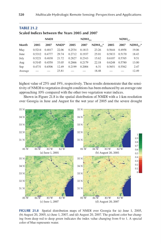
Shown in Figure 21.8 is the spatial distribution of NMDI with a 1-km resolution
over Georgia in June and August for the wet year of 2005 and the severe drought
TABLE 21.2
Scaled Indices between the Years 2005 and 2007
Month
NMDI
NDWI 2,6
NDWI 2,7
2005
2007 NMDI* 2005
2007 NDWI 2,6 * 2005
2007 NDWI 2,7 *
May
0.5214 0.4817
22.06
0.2534 0.1813
23.26
0.5644 0.4958
19.06
June
0.5312 0.4777
29.74
0.2712 0.1937
25.01
0.5833 0.5170
18.43
July
0.5221 0.4830
21.72
0.2827 0.2343
15.62
0.6107 0.5765
9.51
Aug
0.5145 0.4550
33.05
0.2866 0.2179
22.18
0.6248 0.5780
13.00
Sep
0.4731 0.4506
12.49
0.2199 0.2004
6.31
0.5651 0.5562
2.47
Average
—
—
23.81
—
—
18.48
—
—
12.49
(a) June 1, 2005
(b) August 20, 2005
(c) June 1, 2007
(d) August 20, 2007
35 N
34 N
33 N
32 N
31 N
85 W
84 W
83 W
82 W
85 W
84 W
83 W
82 W
85 W
84 W
83 W
82 W
85 W
84 W
83 W
82 W
1
0.9
0.8
0.7
0.6
0.5
0.4
0.3
0.2
0.1
0
35 N
34 N
33 N
32 N
31 N
35 N
34 N
33 N
32 N
31 N
35 N
34 N
33 N
32 N
31 N
FIGURE 21.8 Spatial distribution maps of NMDI over Georgia for (a) June 1, 2005,
(b) August 20, 2005, (c) June 1, 2007, and (d) August 20, 2007. The gradient color bar changing from deep red to deep green indicates the index value changing from 0 to 1. A special
color of blue represents water.
Multiscale Hydrologic Remote Sensing: Perspectives and Applications
highest value of 25% and 19%, respectively. These results demonstrate that the sensitivity of NMDI to vegetation drought conditions has been enhanced by an average rate
approaching 10% compared with the other two vegetation water indices.
Shown in Figure 21.8 is the spatial distribution of NMDI with a 1-km resolution
over Georgia in June and August for the wet year of 2005 and the severe drought
TABLE 21.2
Scaled Indices between the Years 2005 and 2007
Month
NMDI
NDWI 2,6
NDWI 2,7
2005
2007 NMDI* 2005
2007 NDWI 2,6 * 2005
2007 NDWI 2,7 *
May
0.5214 0.4817
22.06
0.2534 0.1813
23.26
0.5644 0.4958
19.06
June
0.5312 0.4777
29.74
0.2712 0.1937
25.01
0.5833 0.5170
18.43
July
0.5221 0.4830
21.72
0.2827 0.2343
15.62
0.6107 0.5765
9.51
Aug
0.5145 0.4550
33.05
0.2866 0.2179
22.18
0.6248 0.5780
13.00
Sep
0.4731 0.4506
12.49
0.2199 0.2004
6.31
0.5651 0.5562
2.47
Average
—
—
23.81
—
—
18.48
—
—
12.49
(a) June 1, 2005
(b) August 20, 2005
(c) June 1, 2007
(d) August 20, 2007
35 N
34 N
33 N
32 N
31 N
85 W
84 W
83 W
82 W
85 W
84 W
83 W
82 W
85 W
84 W
83 W
82 W
85 W
84 W
83 W
82 W
1
0.9
0.8
0.7
0.6
0.5
0.4
0.3
0.2
0.1
0
35 N
34 N
33 N
32 N
31 N
35 N
34 N
33 N
32 N
31 N
35 N
34 N
33 N
32 N
31 N
FIGURE 21.8 Spatial distribution maps of NMDI over Georgia for (a) June 1, 2005,
(b) August 20, 2005, (c) June 1, 2007, and (d) August 20, 2007. The gradient color bar changing from deep red to deep green indicates the index value changing from 0 to 1. A special
color of blue represents water.