

403
Global Soil Moisture Estimation Using Microwave Remote Sensing
2008). It is anticipated that the SMOS data will help improve short- and mediumterm weather forecasts and also have practical applications in areas such as agriculture and water resource management. Additionally, climate models and global
energy and water cycle studies should benefit from having a more precise picture of
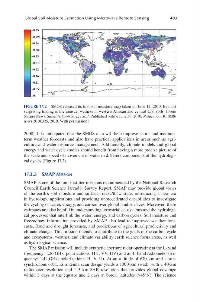
the scale and speed of movement of water in different components of the hydrological cycles (Figure 17.2).
17.3.3 SMaP MiSSion
SMAP is one of the four first-tier missions recommended by the National Research
Council Earth Science Decadal Survey Report. SMAP may provide global views
of the earth’s soil moisture and surface freeze/thaw state, introducing a new era
in hydrologic applications and providing unprecedented capabilities to investigate
the cycling of water, energy, and carbon over global land surfaces. Moreover, these
estimates are also helpful in understanding terrestrial ecosystems and the hydrological processes that interlink the water, energy, and carbon cycles. Soil moisture and
freeze/thaw information provided by SMAP also lead to improved weather forecasts, flood and drought forecasts, and predictions of agricultural productivity and
climate change. This mission intends to contribute to the goals of the carbon cycle
and ecosystems, weather, and climate variability earth science focus areas, as well
as hydrological science.
The SMAP mission will include synthetic aperture radar operating at the L-band
(frequency: 1.26 GHz; polarizations: HH, VV, HV) and an L-band radiometer (frequency: 1.41 GHz; polarizations: H, V, U). At an altitude of 670 km and a sunsynchronous orbit, its antenna scan design yields a 1000-km swath, with a 40-km
radiometer resolution and 1–3 km SAR resolution that provides global coverage
within 3 days at the equator and 2 days at boreal latitudes (>45°N). The science
+0.55
+0.495
+0.44
+0.385
+0.33
+0.275
+0.22
+0.165
+0.11
+0.055
+0.
–135
–90
–45
–30
–60
0
30
60
45
90
135
FIGURE 17.2 SMOS released its first soil moisture map taken on June 12, 2010. Its most
surprising finding is the unusual wetness in western African and central U.S. soils. (From
Nature News, Satellite Spots Soggy Soil, Published online June 30, 2010, Nature, doi:10.1038/
news.2010.325, 2010. With permission.)
Global Soil Moisture Estimation Using Microwave Remote Sensing
2008). It is anticipated that the SMOS data will help improve short- and mediumterm weather forecasts and also have practical applications in areas such as agriculture and water resource management. Additionally, climate models and global
energy and water cycle studies should benefit from having a more precise picture of
the scale and speed of movement of water in different components of the hydrological cycles (Figure 17.2).
17.3.3 SMaP MiSSion
SMAP is one of the four first-tier missions recommended by the National Research
Council Earth Science Decadal Survey Report. SMAP may provide global views
of the earth’s soil moisture and surface freeze/thaw state, introducing a new era
in hydrologic applications and providing unprecedented capabilities to investigate
the cycling of water, energy, and carbon over global land surfaces. Moreover, these
estimates are also helpful in understanding terrestrial ecosystems and the hydrological processes that interlink the water, energy, and carbon cycles. Soil moisture and
freeze/thaw information provided by SMAP also lead to improved weather forecasts, flood and drought forecasts, and predictions of agricultural productivity and
climate change. This mission intends to contribute to the goals of the carbon cycle
and ecosystems, weather, and climate variability earth science focus areas, as well
as hydrological science.
The SMAP mission will include synthetic aperture radar operating at the L-band
(frequency: 1.26 GHz; polarizations: HH, VV, HV) and an L-band radiometer (frequency: 1.41 GHz; polarizations: H, V, U). At an altitude of 670 km and a sunsynchronous orbit, its antenna scan design yields a 1000-km swath, with a 40-km
radiometer resolution and 1–3 km SAR resolution that provides global coverage
within 3 days at the equator and 2 days at boreal latitudes (>45°N). The science
+0.55
+0.495
+0.44
+0.385
+0.33
+0.275
+0.22
+0.165
+0.11
+0.055
+0.
–135
–90
–45
–30
–60
0
30
60
45
90
135
FIGURE 17.2 SMOS released its first soil moisture map taken on June 12, 2010. Its most
surprising finding is the unusual wetness in western African and central U.S. soils. (From
Nature News, Satellite Spots Soggy Soil, Published online June 30, 2010, Nature, doi:10.1038/
news.2010.325, 2010. With permission.)