

402
Multiscale Hydrologic Remote Sensing: Perspectives and Applications
These measurements are derived from the sensitivity of microwave surface emissivity to the moisture content of the top few centimeters of soil. The availability of
global daily AMSR-E soil moisture products since 2002 can be potentially useful for
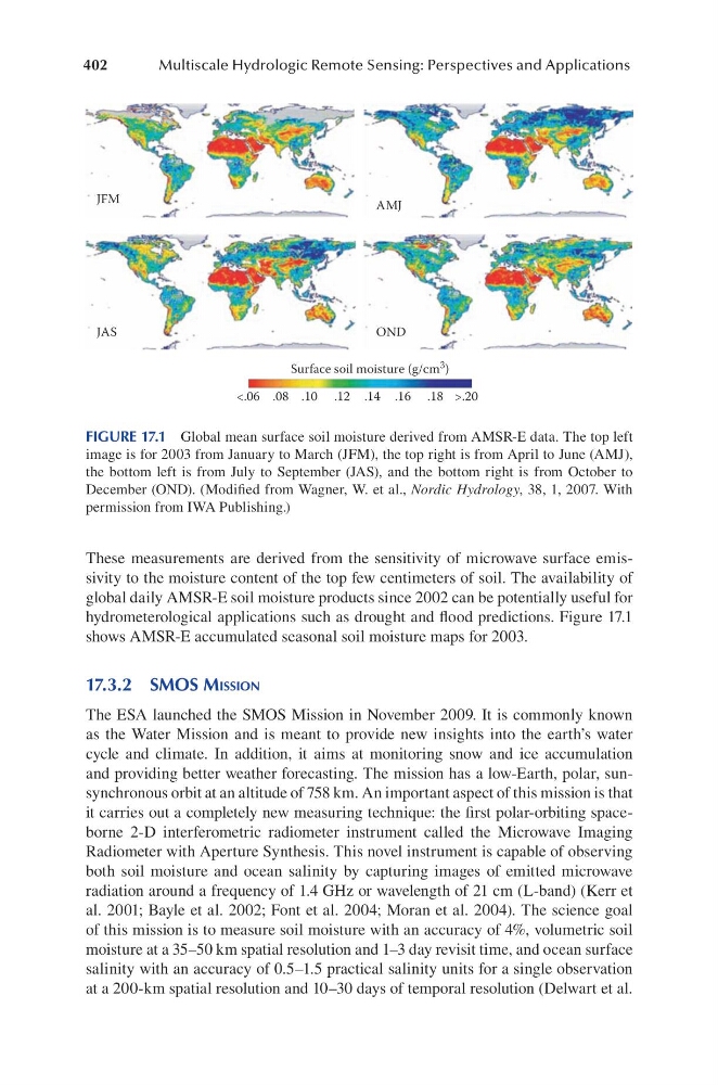
hydrometerological applications such as drought and flood predictions. Figure 17.1
shows AMSR-E accumulated seasonal soil moisture maps for 2003.
17.3.2 SMoS MiSSion
The ESA launched the SMOS Mission in November 2009. It is commonly known
as the Water Mission and is meant to provide new insights into the earth’s water
cycle and climate. In addition, it aims at monitoring snow and ice accumulation
and providing better weather forecasting. The mission has a low-Earth, polar, sunsynchronous orbit at an altitude of 758 km. An important aspect of this mission is that
it carries out a completely new measuring technique: the first polar-orbiting spaceborne 2-D interferometric radiometer instrument called the Microwave Imaging
Radiometer with Aperture Synthesis. This novel instrument is capable of observing
both soil moisture and ocean salinity by capturing images of emitted microwave
radiation around a frequency of 1.4 GHz or wavelength of 21 cm (L-band) (Kerr et
al. 2001; Bayle et al. 2002; Font et al. 2004; Moran et al. 2004). The science goal
of this mission is to measure soil moisture with an accuracy of 4%, volumetric soil
moisture at a 35–50 km spatial resolution and 1–3 day revisit time, and ocean surface
salinity with an accuracy of 0.5–1.5 practical salinity units for a single observation
at a 200-km spatial resolution and 10–30 days of temporal resolution (Delwart et al.
JFM
AMJ
OND
JAS
Surface soil moisture (g/cm 3 )
<.06 .08 .10 .12 .14 .16 .18 >.20
FIGURE 17.1 Global mean surface soil moisture derived from AMSR-E data. The top left
image is for 2003 from January to March (JFM), the top right is from April to June (AMJ),
the bottom left is from July to September (JAS), and the bottom right is from October to
December (OND). (Modified from Wagner, W. et al., Nordic Hydrology, 38, 1, 2007. With
permission from IWA Publishing.)
Multiscale Hydrologic Remote Sensing: Perspectives and Applications
These measurements are derived from the sensitivity of microwave surface emissivity to the moisture content of the top few centimeters of soil. The availability of
global daily AMSR-E soil moisture products since 2002 can be potentially useful for
hydrometerological applications such as drought and flood predictions. Figure 17.1
shows AMSR-E accumulated seasonal soil moisture maps for 2003.
17.3.2 SMoS MiSSion
The ESA launched the SMOS Mission in November 2009. It is commonly known
as the Water Mission and is meant to provide new insights into the earth’s water
cycle and climate. In addition, it aims at monitoring snow and ice accumulation
and providing better weather forecasting. The mission has a low-Earth, polar, sunsynchronous orbit at an altitude of 758 km. An important aspect of this mission is that
it carries out a completely new measuring technique: the first polar-orbiting spaceborne 2-D interferometric radiometer instrument called the Microwave Imaging
Radiometer with Aperture Synthesis. This novel instrument is capable of observing
both soil moisture and ocean salinity by capturing images of emitted microwave
radiation around a frequency of 1.4 GHz or wavelength of 21 cm (L-band) (Kerr et
al. 2001; Bayle et al. 2002; Font et al. 2004; Moran et al. 2004). The science goal
of this mission is to measure soil moisture with an accuracy of 4%, volumetric soil
moisture at a 35–50 km spatial resolution and 1–3 day revisit time, and ocean surface
salinity with an accuracy of 0.5–1.5 practical salinity units for a single observation
at a 200-km spatial resolution and 10–30 days of temporal resolution (Delwart et al.
JFM
AMJ
OND
JAS
Surface soil moisture (g/cm 3 )
<.06 .08 .10 .12 .14 .16 .18 >.20
FIGURE 17.1 Global mean surface soil moisture derived from AMSR-E data. The top left
image is for 2003 from January to March (JFM), the top right is from April to June (AMJ),
the bottom left is from July to September (JAS), and the bottom right is from October to
December (OND). (Modified from Wagner, W. et al., Nordic Hydrology, 38, 1, 2007. With
permission from IWA Publishing.)