

404
Multiscale Hydrologic Remote Sensing: Perspectives and Applications
goal of SMAP is to provide estimates of soil moisture in the top 5 cm of soil with an
accuracy of 0.04 cm 3 /cm 3 volumetric soil moisture, at a 10-km resolution, with 3-day
average intervals over the global land area. These measurements will not be suitable
for regions with snow and ice, mountainous topography, open water, or dense vegetation with total water content greater than 5 kg/m 2 (Entekhabi et al. 2010; Das et
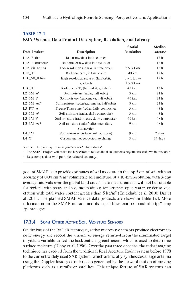
al. 2011). The planned SMAP science data products are shown in Table 17.1. More
information on the SMAP mission and its capabilities can be found at http://smap
.jpl.nasa.gov.
17.3.4 SoMe otheR active Soil MoiStuRe SenSoRS
On the basis of the RaDaR technique, active microwave sensors produce electromagnetic energy and record the amount of energy returned from the illuminated target
to yield a variable called the backscattering coefficient, which is used to determine
surface moisture (Ulaby et al. 1986). Over the past three decades, the radar imaging
technique has evolved from the traditional Real Aperture Radar system before 1978
to the current widely used SAR system, which artificially synthesizes a large antenna
using the Doppler history of radar echo generated by the forward motion of moving
platforms such as aircrafts or satellites. This unique feature of SAR systems can
TABLE 17.1
SMAP Science Data Product Description, Resolution, and Latency
Data Product
Description
Spatial
Resolution
Median
Latency a
L1A_Radar
Radar raw data in time order
—
12 h
L1A_Radiometer
Radiometer raw data in time order
—
12 h
L1B_S0_LoRes
Low resolution radar σ o in time order
5 × 30 km
12 h
L1B_TB
Radiometer T B in time order
40 km
12 h
L1C_S0_HiRes
High-resolution radar σ o (half orbit,
gridded)
1 × 1 km to
1 × 30 km
12 h
L1C_TB
Radiometer T B (half orbit, gridded)
40 km
12 h
L2_SM_A b
Soil moisture (radar, half orbit)
3 km
24 h
L2_SM_P
Soil moisture (radiometer, half orbit)
40 km
24 h
L2_SM_A/P
Soil moisture (radar/radiometer, half orbit)
9 km
24 h
L3_F/T_A
Freeze/ Thaw state (radar, daily composite)
3 km
48 h
L3_SM_A b
Soil moisture (radar, daily composite)
3 km
48 h
L3_SM_P
Soil moisture (radiometer, daily composite)
40 km
48 h
L3_SM_A/P
Soil moisture (radar/radiometer, daily
composite)
9 km
48 h
L4_SM
Soil moisture (surface and root zone)
9 km
7 days
L4_C
Carbon and net ecosystem exchange
3 km
14 days
Source: http://smap.jpl.nasa.gov/science/dataproducts/.
a The SMAP Project will make the best effort to reduce the data latencies beyond those shown in this table.
b Research product with possible reduced accuracy.
Multiscale Hydrologic Remote Sensing: Perspectives and Applications
goal of SMAP is to provide estimates of soil moisture in the top 5 cm of soil with an
accuracy of 0.04 cm 3 /cm 3 volumetric soil moisture, at a 10-km resolution, with 3-day
average intervals over the global land area. These measurements will not be suitable
for regions with snow and ice, mountainous topography, open water, or dense vegetation with total water content greater than 5 kg/m 2 (Entekhabi et al. 2010; Das et
al. 2011). The planned SMAP science data products are shown in Table 17.1. More
information on the SMAP mission and its capabilities can be found at http://smap
.jpl.nasa.gov.
17.3.4 SoMe otheR active Soil MoiStuRe SenSoRS
On the basis of the RaDaR technique, active microwave sensors produce electromagnetic energy and record the amount of energy returned from the illuminated target
to yield a variable called the backscattering coefficient, which is used to determine
surface moisture (Ulaby et al. 1986). Over the past three decades, the radar imaging
technique has evolved from the traditional Real Aperture Radar system before 1978
to the current widely used SAR system, which artificially synthesizes a large antenna
using the Doppler history of radar echo generated by the forward motion of moving
platforms such as aircrafts or satellites. This unique feature of SAR systems can
TABLE 17.1
SMAP Science Data Product Description, Resolution, and Latency
Data Product
Description
Spatial
Resolution
Median
Latency a
L1A_Radar
Radar raw data in time order
—
12 h
L1A_Radiometer
Radiometer raw data in time order
—
12 h
L1B_S0_LoRes
Low resolution radar σ o in time order
5 × 30 km
12 h
L1B_TB
Radiometer T B in time order
40 km
12 h
L1C_S0_HiRes
High-resolution radar σ o (half orbit,
gridded)
1 × 1 km to
1 × 30 km
12 h
L1C_TB
Radiometer T B (half orbit, gridded)
40 km
12 h
L2_SM_A b
Soil moisture (radar, half orbit)
3 km
24 h
L2_SM_P
Soil moisture (radiometer, half orbit)
40 km
24 h
L2_SM_A/P
Soil moisture (radar/radiometer, half orbit)
9 km
24 h
L3_F/T_A
Freeze/ Thaw state (radar, daily composite)
3 km
48 h
L3_SM_A b
Soil moisture (radar, daily composite)
3 km
48 h
L3_SM_P
Soil moisture (radiometer, daily composite)
40 km
48 h
L3_SM_A/P
Soil moisture (radar/radiometer, daily
composite)
9 km
48 h
L4_SM
Soil moisture (surface and root zone)
9 km
7 days
L4_C
Carbon and net ecosystem exchange
3 km
14 days
Source: http://smap.jpl.nasa.gov/science/dataproducts/.
a The SMAP Project will make the best effort to reduce the data latencies beyond those shown in this table.
b Research product with possible reduced accuracy.