

381
Global Precipitation Estimation and Applications
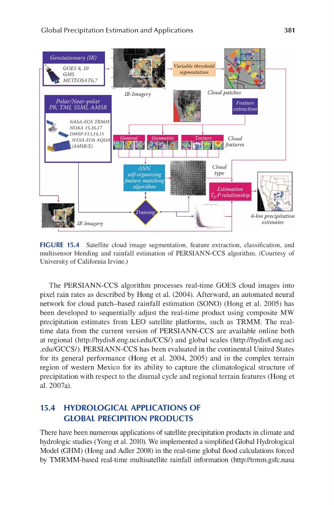
The PERSIANN-CCS algorithm processes real-time GOES cloud images into
pixel rain rates as described by Hong et al. (2004). Afterward, an automated neural
network for cloud patch–based rainfall estimation (SONO) (Hong et al. 2005) has
been developed to sequentially adjust the real-time product using composite MW
precipitation estimates from LEO satellite platforms, such as TRMM. The realtime data from the current version of PERSIANN-CCS are available online both
at regional (http://hydis8.eng.uci.edu/CCS/) and global scales (http://hydis8.eng.uci
.edu/GCCS/). PERSIANN-CCS has been evaluated in the continental United States
for its general performance (Hong et al. 2004, 2005) and in the complex terrain
region of western Mexico for its ability to capture the climatological structure of
precipitation with respect to the diurnal cycle and regional terrain features (Hong et
al. 2007a).
15.4 HYDROLOGICAL APPLICATIONS OF
GLOBAL PRECIPITION PRODUCTS
There have been numerous applications of satellite precipitation products in climate and
hydrologic studies (Yong et al. 2010). We implemented a simplified Global Hydrological
Model (GHM) (Hong and Adler 2008) in the real-time global flood calculations forced
by TMRMM-based real-time multisatellite rainfall information (http://trmm.gsfc.nasa
Geostationary (IR)
IR-Imagery
GOES 8, 10
GMS
METEOSAT6,7
NASA-EOS TRMM
NOAA 15,16,17
DMSP F13,14,15
NASA-EOS AQUA
(AMSR/E)
IR Imagery
Cloud patches
Cloud
features
Cloud
type
4-km precipitation
estimates
Variable threshold
segmentation
Polar/Near-polar
PR, TMI, SSMI, AMSR
Feature
extraction
ANN
self-organizing
feature matching
algorithm
Training
Estimation
T b -P relationship
General
Geometric
Texture
FIGURE 15.4 Satellite cloud image segmentation, feature extraction, classification, and
multisensor blending and rainfall estimation of PERSIANN-CCS algorithm. (Courtesy of
University of California Irvine.)
Global Precipitation Estimation and Applications
The PERSIANN-CCS algorithm processes real-time GOES cloud images into
pixel rain rates as described by Hong et al. (2004). Afterward, an automated neural
network for cloud patch–based rainfall estimation (SONO) (Hong et al. 2005) has
been developed to sequentially adjust the real-time product using composite MW
precipitation estimates from LEO satellite platforms, such as TRMM. The realtime data from the current version of PERSIANN-CCS are available online both
at regional (http://hydis8.eng.uci.edu/CCS/) and global scales (http://hydis8.eng.uci
.edu/GCCS/). PERSIANN-CCS has been evaluated in the continental United States
for its general performance (Hong et al. 2004, 2005) and in the complex terrain
region of western Mexico for its ability to capture the climatological structure of
precipitation with respect to the diurnal cycle and regional terrain features (Hong et
al. 2007a).
15.4 HYDROLOGICAL APPLICATIONS OF
GLOBAL PRECIPITION PRODUCTS
There have been numerous applications of satellite precipitation products in climate and
hydrologic studies (Yong et al. 2010). We implemented a simplified Global Hydrological
Model (GHM) (Hong and Adler 2008) in the real-time global flood calculations forced
by TMRMM-based real-time multisatellite rainfall information (http://trmm.gsfc.nasa
Geostationary (IR)
IR-Imagery
GOES 8, 10
GMS
METEOSAT6,7
NASA-EOS TRMM
NOAA 15,16,17
DMSP F13,14,15
NASA-EOS AQUA
(AMSR/E)
IR Imagery
Cloud patches
Cloud
features
Cloud
type
4-km precipitation
estimates
Variable threshold
segmentation
Polar/Near-polar
PR, TMI, SSMI, AMSR
Feature
extraction
ANN
self-organizing
feature matching
algorithm
Training
Estimation
T b -P relationship
General
Geometric
Texture
FIGURE 15.4 Satellite cloud image segmentation, feature extraction, classification, and
multisensor blending and rainfall estimation of PERSIANN-CCS algorithm. (Courtesy of
University of California Irvine.)