

380
Multiscale Hydrologic Remote Sensing: Perspectives and Applications
post-real-time TMPA from version 6 to version 7 (in beta test at press time) is
designed to provide a variety of improvements that increase the list of input datasets and correct several issues. Future enhancements for the TMPA will include
improved error estimation, extension to higher latitudes, and a shift to a Lagrangian
time interpolation scheme.
15.3.4 PeRSiann-ccS algoRithM
The PERSIANN-CCS algorithm extracts local and regional cloud features from
GEO IR satellite imagery, with MW and ground radar rainfall data blending or
training, in estimating finer-scale (i.e., 0.04° × 0.04°, 30-min) rainfall products. As
shown in Figure 15.4, this algorithm processes satellite cloud images into pixel rain
rates by (1) separating cloud images into distinctive cloud patches through a watershed segmentation algorithm; (2) extracting pixel-, window-, and batch-level cloud
features, including coldness, geometry, and texture; (3) clustering cloud patches into
well-organized subgroups via a self-organizing feature mapping algorithm; and (4)
mapping the nonlinear cloud-top temperature and rainfall (T b –R) relationships for
the hundreds of classified cloud groups by blending with the MW or gauge-corrected radar rainfall database, with one nonlinear fitting curve per cluster. Thus,
PERSIANN-CCS is able to generate various rain rates at a given brightness temperature and variable rain/no-rain IR thresholds for different cloud types, which
overcomes the one-to-one mapping limitation of a single IR–RR function for the full
spectrum of cloud–rainfall conditions. In addition, PERSIANN-CCS offers insights
into explaining the classified patch features with respect to their pixel rainfall distributions. PERSIANN-CCS can be used not only as a fine-scale rainfall estimation
scheme but also as an explanatory tool to analyze the cloud–rainfall system.
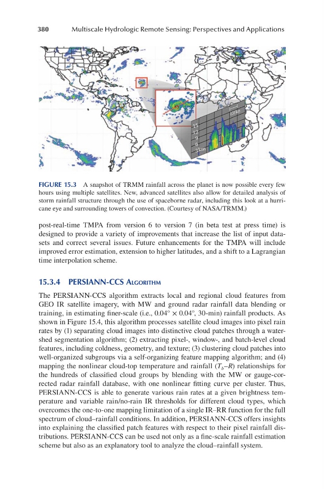
FIGURE 15.3 A snapshot of TRMM rainfall across the planet is now possible every few
hours using multiple satellites. New, advanced satellites also allow for detailed analysis of
storm rainfall structure through the use of spaceborne radar, including this look at a hurricane eye and surrounding towers of convection. (Courtesy of NASA/TRMM.)
Multiscale Hydrologic Remote Sensing: Perspectives and Applications
post-real-time TMPA from version 6 to version 7 (in beta test at press time) is
designed to provide a variety of improvements that increase the list of input datasets and correct several issues. Future enhancements for the TMPA will include
improved error estimation, extension to higher latitudes, and a shift to a Lagrangian
time interpolation scheme.
15.3.4 PeRSiann-ccS algoRithM
The PERSIANN-CCS algorithm extracts local and regional cloud features from
GEO IR satellite imagery, with MW and ground radar rainfall data blending or
training, in estimating finer-scale (i.e., 0.04° × 0.04°, 30-min) rainfall products. As
shown in Figure 15.4, this algorithm processes satellite cloud images into pixel rain
rates by (1) separating cloud images into distinctive cloud patches through a watershed segmentation algorithm; (2) extracting pixel-, window-, and batch-level cloud
features, including coldness, geometry, and texture; (3) clustering cloud patches into
well-organized subgroups via a self-organizing feature mapping algorithm; and (4)
mapping the nonlinear cloud-top temperature and rainfall (T b –R) relationships for
the hundreds of classified cloud groups by blending with the MW or gauge-corrected radar rainfall database, with one nonlinear fitting curve per cluster. Thus,
PERSIANN-CCS is able to generate various rain rates at a given brightness temperature and variable rain/no-rain IR thresholds for different cloud types, which
overcomes the one-to-one mapping limitation of a single IR–RR function for the full
spectrum of cloud–rainfall conditions. In addition, PERSIANN-CCS offers insights
into explaining the classified patch features with respect to their pixel rainfall distributions. PERSIANN-CCS can be used not only as a fine-scale rainfall estimation
scheme but also as an explanatory tool to analyze the cloud–rainfall system.
FIGURE 15.3 A snapshot of TRMM rainfall across the planet is now possible every few
hours using multiple satellites. New, advanced satellites also allow for detailed analysis of
storm rainfall structure through the use of spaceborne radar, including this look at a hurricane eye and surrounding towers of convection. (Courtesy of NASA/TRMM.)