

93
Thermal Radiation and Energy Closure Assessment
This patchwork environment creates a complicated network of dry-to-wet contrasts, creating large vertical gradients in saturation deficit so that variations and
strength of wind speeds often produce large changes in saturation deficit over the
irrigated surface. The advection of saturation deficit in which dry surfaces act as
local sources of saturation deficit (warmer and drier air) can move over wetter
surfaces (from irrigation) and thus enhance ET. Moreover, the regional extent of
this patchwork surface lends itself to an additional but much larger spatial scale of
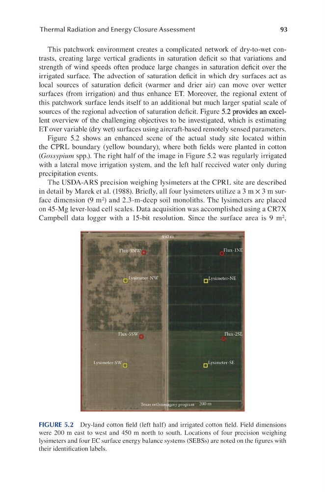
sources of the regional advection of saturation deficit. Figure 5.2 provides an excel5.2 provides an excel.2 provides an excellent overview of the challenging objectives to be investigated, which is estimating
ET over variable (dry wet) surfaces using aircraft-based remotely sensed parameters.
Figure 5.2 shows an enhanced scene of the actual study site located within
the CPRL boundary (yellow boundary), where both fields were planted in cotton
(Gossypium spp.). The right half of the image in Figure 5.2 was regularly irrigated
with a lateral move irrigation system, and the left half received water only during
precipitation events.
The USDA-ARS precision weighing lysimeters at the CPRL site are described
in detail by Marek et al. (1988). Briefly, all four lysimeters utilize a 3 m × 3 m surface dimension (9 m 2 ) and 2.3-m-deep soil monoliths. The lysimeters are placed
on 45-Mg lever-load cell scales. Data acquisition was accomplished using a CR7X
Campbell data logger with a 15-bit resolution. Since the surface area is 9 m 2 ,
450 m
Flux-3NW
Flux-1NE
Flux-2SE
Flux-5SW
Lysimeter-SW
Lysimeter-SE
Lysimeter-NE
Lysimeter-NW
200 m
Texas orthoimagery program
FIGURE 5.2 Dry-land cotton field (left half) and irrigated cotton field. Field dimensions
were 200 m east to west and 450 m north to south. Locations of four precision weighing
lysimeters and four EC surface energy balance systems (SEBSs) are noted on the figures with
their identification labels.
Thermal Radiation and Energy Closure Assessment
This patchwork environment creates a complicated network of dry-to-wet contrasts, creating large vertical gradients in saturation deficit so that variations and
strength of wind speeds often produce large changes in saturation deficit over the
irrigated surface. The advection of saturation deficit in which dry surfaces act as
local sources of saturation deficit (warmer and drier air) can move over wetter
surfaces (from irrigation) and thus enhance ET. Moreover, the regional extent of
this patchwork surface lends itself to an additional but much larger spatial scale of
sources of the regional advection of saturation deficit. Figure 5.2 provides an excel5.2 provides an excel.2 provides an excellent overview of the challenging objectives to be investigated, which is estimating
ET over variable (dry wet) surfaces using aircraft-based remotely sensed parameters.
Figure 5.2 shows an enhanced scene of the actual study site located within
the CPRL boundary (yellow boundary), where both fields were planted in cotton
(Gossypium spp.). The right half of the image in Figure 5.2 was regularly irrigated
with a lateral move irrigation system, and the left half received water only during
precipitation events.
The USDA-ARS precision weighing lysimeters at the CPRL site are described
in detail by Marek et al. (1988). Briefly, all four lysimeters utilize a 3 m × 3 m surface dimension (9 m 2 ) and 2.3-m-deep soil monoliths. The lysimeters are placed
on 45-Mg lever-load cell scales. Data acquisition was accomplished using a CR7X
Campbell data logger with a 15-bit resolution. Since the surface area is 9 m 2 ,
450 m
Flux-3NW
Flux-1NE
Flux-2SE
Flux-5SW
Lysimeter-SW
Lysimeter-SE
Lysimeter-NE
Lysimeter-NW
200 m
Texas orthoimagery program
FIGURE 5.2 Dry-land cotton field (left half) and irrigated cotton field. Field dimensions
were 200 m east to west and 450 m north to south. Locations of four precision weighing
lysimeters and four EC surface energy balance systems (SEBSs) are noted on the figures with
their identification labels.