

13.3.3 Characterizing the US Wildfire
Regimes (Malamud et al.)
The spread of wildfires and their severity patterns
show distinct regional styles across the United
States (Malamud et al. 2005). Using highresolution Forest Service wildfire statistics, this
study was based on 31 years (1970–2000) of
wildfire data consisting of 88,916 fires all of
which were at least 1 acre or larger and within
the National Forest System. To allow spatial
analysis with regard to the biophysical factors
that drive wildfire regimes, the researchers classified the wildfire data into ecoregion divisions
(areas of common climate, vegetation, and elevation). In each ecoregion, they asked: What is
the frequency-area distribution of wildfires? The
study compared area burned, number of fires, and
the wildfire recurrence interval. These
parameters were calculated at the ecoregion division level. The study created maps to display
wildfire patterns and risk for the entire continental United States.
The authors found that the ratio of large to
small wildfires decreases from east to west
(Fig. 13.3a), meaning a relatively higher proportion of large fires occurs in the west compared to
the east. This may be due to greater population
density and increased forest fragmentation.
Alternatively, the observed gradient may be due
to natural drivers, with climate, vegetation, and
topography producing conditions more conducive to large wildfires.
The fire recurrence interval differs markedly
between ecoregions. For example, the fire cycle
values ranged from 13 years for the Mediterranean Mountains Ecoregion to 203 years for the
Warm Continental Ecoregion (Fig. 13.3b). Note
the term “fire cycle” does not mean that a fire will
occur “every” 13 years, or “every” 203 years. It
is a probabilistic hazard dealing with possibilities
rather than absolutes: a recurrence interval of 100
years would mean that in ANY year, we have a 1
in 100 chance of a fire of a given size.
13.3.4 Other Studies
In other studies, gradients similar to those
observed by Malamud et al. (2005) have been
described and related to climate and vegetation.
Turner and Romme (1994) describe wildfire
occurrence gradients as a function of elevation
and latitude. They attribute these gradients to
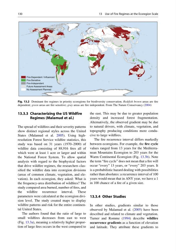
Fig. 13.2 Dominant fire regimes in priority ecoregions for biodiversity conservation. Reddish brown areas are fire
dependent; green areas are fire sensitive; gray areas are fire independent. From The Nature Conservancy (2004)
130
13 Use of Fire Regimes at the Ecoregion Scale
Regimes (Malamud et al.)
The spread of wildfires and their severity patterns
show distinct regional styles across the United
States (Malamud et al. 2005). Using highresolution Forest Service wildfire statistics, this
study was based on 31 years (1970–2000) of
wildfire data consisting of 88,916 fires all of
which were at least 1 acre or larger and within
the National Forest System. To allow spatial
analysis with regard to the biophysical factors
that drive wildfire regimes, the researchers classified the wildfire data into ecoregion divisions
(areas of common climate, vegetation, and elevation). In each ecoregion, they asked: What is
the frequency-area distribution of wildfires? The
study compared area burned, number of fires, and
the wildfire recurrence interval. These
parameters were calculated at the ecoregion division level. The study created maps to display
wildfire patterns and risk for the entire continental United States.
The authors found that the ratio of large to
small wildfires decreases from east to west
(Fig. 13.3a), meaning a relatively higher proportion of large fires occurs in the west compared to
the east. This may be due to greater population
density and increased forest fragmentation.
Alternatively, the observed gradient may be due
to natural drivers, with climate, vegetation, and
topography producing conditions more conducive to large wildfires.
The fire recurrence interval differs markedly
between ecoregions. For example, the fire cycle
values ranged from 13 years for the Mediterranean Mountains Ecoregion to 203 years for the
Warm Continental Ecoregion (Fig. 13.3b). Note
the term “fire cycle” does not mean that a fire will
occur “every” 13 years, or “every” 203 years. It
is a probabilistic hazard dealing with possibilities
rather than absolutes: a recurrence interval of 100
years would mean that in ANY year, we have a 1
in 100 chance of a fire of a given size.
13.3.4 Other Studies
In other studies, gradients similar to those
observed by Malamud et al. (2005) have been
described and related to climate and vegetation.
Turner and Romme (1994) describe wildfire
occurrence gradients as a function of elevation
and latitude. They attribute these gradients to
Fig. 13.2 Dominant fire regimes in priority ecoregions for biodiversity conservation. Reddish brown areas are fire
dependent; green areas are fire sensitive; gray areas are fire independent. From The Nature Conservancy (2004)
130
13 Use of Fire Regimes at the Ecoregion Scale