

Missouri, it is found almost exclusively in the
Ozark Uplands ecoregion.
12.2.4 Design of Sampling Networks
Considered collectively, the conceptual material
presented to this point positions ecoregion users
to design efficient sampling networks. Ecoregion
maps delimit large areas of similar climate where
similar ecosystems occur on similar sites. As we
have seen, local ecosystems occur in predictable
patterns within a particular region. Sampling representative types allow a planner, designer, or
manager to extend data to analogous
(unsampled) sites within the region with a high
degree of reliability (Bailey 1991; Robertson and
Wilson 1985), thereby reducing sampling and
monitoring costs. A sampling network design
should capture the local ecosystem patterns and
variation in those patterns within regions exhibit
variation in landform and soil characteristics (see
Chap. 11). Identification of sites based on
ecoregional classification could be used to
impute their characteristics from sampled FIA
sites, for example, using k-Nearest Neighbors or
similar techniques (McRoberts et al. 2002).
Another example comes from the Rocky
Mountains, a temperate steppe mountains
ecoregion. This ecoregion, like all ecoregions,
is a climatic region within which specific plant
successions occur upon specific landform
positions. The most likely successional series
growing on a site within an ecoregion can be
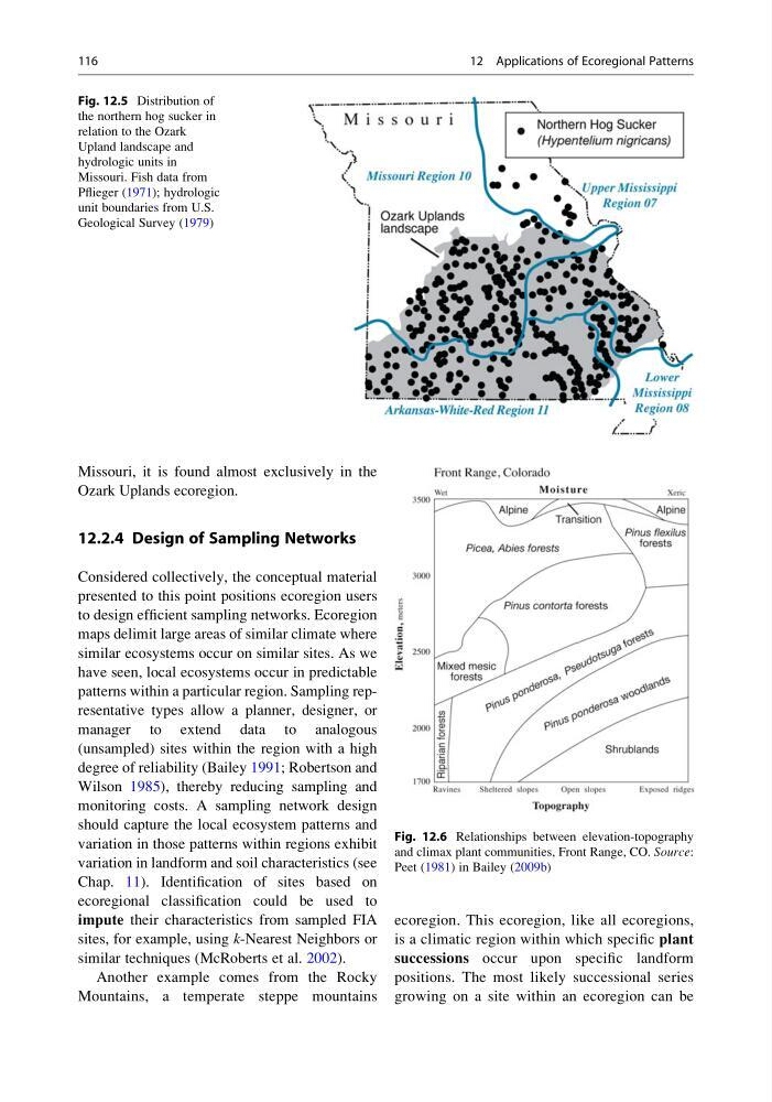
Fig. 12.5 Distribution of
the northern hog sucker in
relation to the Ozark
Upland landscape and
hydrologic units in
Missouri. Fish data from
Pflieger (1971); hydrologic
unit boundaries from U.S.
Geological Survey (1979)
Fig. 12.6 Relationships between elevation-topography
and climax plant communities, Front Range, CO. Source:
Peet (1981) in Bailey (2009b)
116
12 Applications of Ecoregional Patterns
Ozark Uplands ecoregion.
12.2.4 Design of Sampling Networks
Considered collectively, the conceptual material
presented to this point positions ecoregion users
to design efficient sampling networks. Ecoregion
maps delimit large areas of similar climate where
similar ecosystems occur on similar sites. As we
have seen, local ecosystems occur in predictable
patterns within a particular region. Sampling representative types allow a planner, designer, or
manager to extend data to analogous
(unsampled) sites within the region with a high
degree of reliability (Bailey 1991; Robertson and
Wilson 1985), thereby reducing sampling and
monitoring costs. A sampling network design
should capture the local ecosystem patterns and
variation in those patterns within regions exhibit
variation in landform and soil characteristics (see
Chap. 11). Identification of sites based on
ecoregional classification could be used to
impute their characteristics from sampled FIA
sites, for example, using k-Nearest Neighbors or
similar techniques (McRoberts et al. 2002).
Another example comes from the Rocky
Mountains, a temperate steppe mountains
ecoregion. This ecoregion, like all ecoregions,
is a climatic region within which specific plant
successions occur upon specific landform
positions. The most likely successional series
growing on a site within an ecoregion can be
Fig. 12.5 Distribution of
the northern hog sucker in
relation to the Ozark
Upland landscape and
hydrologic units in
Missouri. Fish data from
Pflieger (1971); hydrologic
unit boundaries from U.S.
Geological Survey (1979)
Fig. 12.6 Relationships between elevation-topography
and climax plant communities, Front Range, CO. Source:
Peet (1981) in Bailey (2009b)
116
12 Applications of Ecoregional Patterns