

predicted from landform information if the
vegetation-landform relationships are known in
a particular ecoregion. For example, Douglas-fir
forests occur on moist, mid-elevation sites
within the Front Range of Colorado. Fig. 12.6
shows the relationships between elevationtopography and climax plant communities.
Understanding these relationships, vertically
and horizontally, within ecoregion delineations
allows the transfer of knowledge from research
sites (or inventory plot) to like sites within the
same ecoregion. In fact, O’Brien (1996) and
Rudis (1998) found that surveys involving comprehensive sampling efforts will more accurately characterize unmonitored sites (plots)
when samples are stratified according to
ecologically similar areas such as ecoregions.
Unfortunately, we often do not understand the
spatial relationships between the FIA plots and
the landform-vegetation types within a particular ecoregion. If these were developed, we could
likely produce better small-area estimates of
vegetation conditions.
12.2.5 Transfer Information
Ecoregion maps show areas that are
hypothesized to be analogous with respect to
ecological conditions. Testing and validation of
ecoregion delineations seem to bear this out
(Olson et al. 1982; Inkley and Anderson 1982;
Bailey 1984; McNab and Lloyd 2009). This
makes it possible to transfer knowledge gained
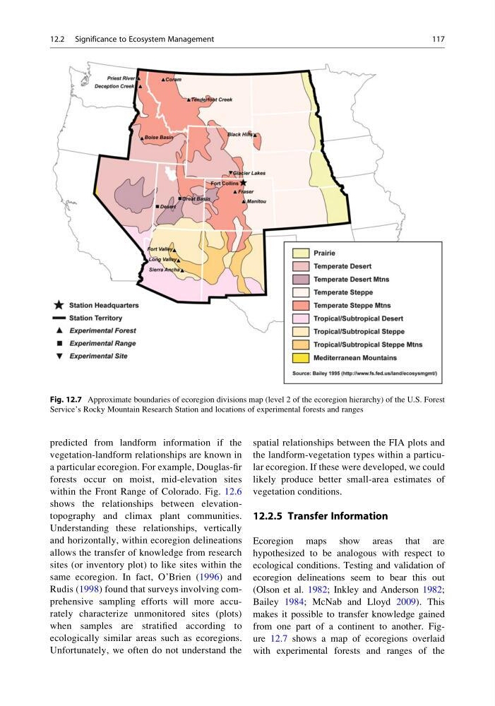
from one part of a continent to another. Figure 12.7 shows a map of ecoregions overlaid
with experimental forests and ranges of the
Fig. 12.7 Approximate boundaries of ecoregion divisions map (level 2 of the ecoregion hierarchy) of the U.S. Forest
Service’s Rocky Mountain Research Station and locations of experimental forests and ranges
12.2 Significance to Ecosystem Management
117
vegetation-landform relationships are known in
a particular ecoregion. For example, Douglas-fir
forests occur on moist, mid-elevation sites
within the Front Range of Colorado. Fig. 12.6
shows the relationships between elevationtopography and climax plant communities.
Understanding these relationships, vertically
and horizontally, within ecoregion delineations
allows the transfer of knowledge from research
sites (or inventory plot) to like sites within the
same ecoregion. In fact, O’Brien (1996) and
Rudis (1998) found that surveys involving comprehensive sampling efforts will more accurately characterize unmonitored sites (plots)
when samples are stratified according to
ecologically similar areas such as ecoregions.
Unfortunately, we often do not understand the
spatial relationships between the FIA plots and
the landform-vegetation types within a particular ecoregion. If these were developed, we could
likely produce better small-area estimates of
vegetation conditions.
12.2.5 Transfer Information
Ecoregion maps show areas that are
hypothesized to be analogous with respect to
ecological conditions. Testing and validation of
ecoregion delineations seem to bear this out
(Olson et al. 1982; Inkley and Anderson 1982;
Bailey 1984; McNab and Lloyd 2009). This
makes it possible to transfer knowledge gained
from one part of a continent to another. Figure 12.7 shows a map of ecoregions overlaid
with experimental forests and ranges of the
Fig. 12.7 Approximate boundaries of ecoregion divisions map (level 2 of the ecoregion hierarchy) of the U.S. Forest
Service’s Rocky Mountain Research Station and locations of experimental forests and ranges
12.2 Significance to Ecosystem Management
117