

be wrong. The ecoregion map is helpful in
identifying the geographic extent over which
results from site-specific studies (such as growth
and yield models) can be reliably extended.
Thus the map identifies areas for the spatial
transferability of models.
In Canada, studies have found that the heightdiameter models of white spruce were different
among different ecoregions (Huang et al. 2000).
Incorrectly applying a height-diameter model
fitted from one ecoregion to different ecoregions
resulted in overestimation between 1 and 29 %,
or underestimation between 2 and 22 %.
Another example makes an even more compelling case. Each of five regional Forest Inventory & Analysis (FIA) programs has developed
its own set of volume models, and the models
have been calibrated for regions defined by political boundaries corresponding to groups of states
rather than ecological boundaries. These regional
models sometimes bear little resemblance to
each other. The same tree shifted a mile in various directions to move from southwest Ohio
(previous Northeastern FIA) to southeast Indiana
(previous North Central FIA) to northern
Kentucky (Southern FIA) could have quite different model-based estimates of volume. Growth
estimates are likely improved if growth models
are calibrated by ecoregions rather than states or
FIA regions (Lessard et al. 2000; McNab and
Keyser 2011).
Models relating lichen community composition in a given ecoregion to major environmental
factors, such as climate and air quality, have been
developed from plot data collected by FIA (WillWolf and Neitlich 2010; Jovan 2008).
12.2.3 Links Between Terrestrial and
Aquatic Systems
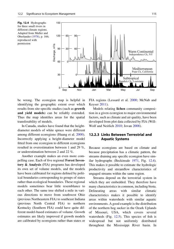
Because ecoregions are based on climate and
because precipitation has a climatic pattern, the
streams draining any specific ecoregion have similar hydrographs (Beckinsale 1971, Fig. 12.4).
This makes it possible to estimate the hydrologic
productivity and streamflow characteristics of
ungaged streams within the same region.
Streams depend on the terrestrial system in
which they are embedded. They therefore have
many characteristics in common, including biota.
Delineating areas with similar climatic
characteristics makes it possible to identify
areas within watersheds with similar aquatic
environments. A good example is the distribution
of the northern hog sucker in the Ozark Uplands
of Missouri, USA, which covers several
watersheds (Fig. 12.5). This species of fish is
widespread but not uniformly distributed
throughout the Mississippi River basin. In
Fig. 12.4 Hydrographs
for three small rivers in
different climate regions.
Adapted from Muller and
Oberlander (1978), p. 166;
reproduced with
permission
12.2 Significance to Ecosystem Management
115
identifying the geographic extent over which
results from site-specific studies (such as growth
and yield models) can be reliably extended.
Thus the map identifies areas for the spatial
transferability of models.
In Canada, studies have found that the heightdiameter models of white spruce were different
among different ecoregions (Huang et al. 2000).
Incorrectly applying a height-diameter model
fitted from one ecoregion to different ecoregions
resulted in overestimation between 1 and 29 %,
or underestimation between 2 and 22 %.
Another example makes an even more compelling case. Each of five regional Forest Inventory & Analysis (FIA) programs has developed
its own set of volume models, and the models
have been calibrated for regions defined by political boundaries corresponding to groups of states
rather than ecological boundaries. These regional
models sometimes bear little resemblance to
each other. The same tree shifted a mile in various directions to move from southwest Ohio
(previous Northeastern FIA) to southeast Indiana
(previous North Central FIA) to northern
Kentucky (Southern FIA) could have quite different model-based estimates of volume. Growth
estimates are likely improved if growth models
are calibrated by ecoregions rather than states or
FIA regions (Lessard et al. 2000; McNab and
Keyser 2011).
Models relating lichen community composition in a given ecoregion to major environmental
factors, such as climate and air quality, have been
developed from plot data collected by FIA (WillWolf and Neitlich 2010; Jovan 2008).
12.2.3 Links Between Terrestrial and
Aquatic Systems
Because ecoregions are based on climate and
because precipitation has a climatic pattern, the
streams draining any specific ecoregion have similar hydrographs (Beckinsale 1971, Fig. 12.4).
This makes it possible to estimate the hydrologic
productivity and streamflow characteristics of
ungaged streams within the same region.
Streams depend on the terrestrial system in
which they are embedded. They therefore have
many characteristics in common, including biota.
Delineating areas with similar climatic
characteristics makes it possible to identify
areas within watersheds with similar aquatic
environments. A good example is the distribution
of the northern hog sucker in the Ozark Uplands
of Missouri, USA, which covers several
watersheds (Fig. 12.5). This species of fish is
widespread but not uniformly distributed
throughout the Mississippi River basin. In
Fig. 12.4 Hydrographs
for three small rivers in
different climate regions.
Adapted from Muller and
Oberlander (1978), p. 166;
reproduced with
permission
12.2 Significance to Ecosystem Management
115