

they are used as baselines for contending with the
temporal variability associated with disturbance
regimes and attending successional states of
vegetation.
11.3 Boundaries Between Zones
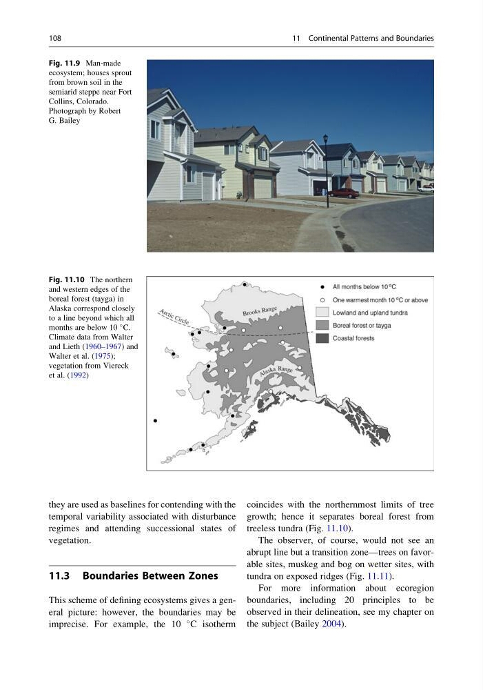
This scheme of defining ecosystems gives a general picture: however, the boundaries may be
imprecise. For example, the 10
C isotherm
coincides with the northernmost limits of tree
growth; hence it separates boreal forest from
treeless tundra (Fig. 11.10).
The observer, of course, would not see an
abrupt line but a transition zone—trees on favorable sites, muskeg and bog on wetter sites, with
tundra on exposed ridges (Fig. 11.11).
For more information about ecoregion
boundaries, including 20 principles to be
observed in their delineation, see my chapter on
the subject (Bailey 2004).
Fig. 11.9 Man-made
ecosystem; houses sprout
from brown soil in the
semiarid steppe near Fort
Collins, Colorado.
Photograph by Robert
G. Bailey
Fig. 11.10 The northern
and western edges of the
boreal forest (tayga) in
Alaska correspond closely
to a line beyond which all
months are below 10
C.
Climate data from Walter
and Lieth (1960–1967) and
Walter et al. (1975);
vegetation from Viereck
et al. (1992)
108
11 Continental Patterns and Boundaries
temporal variability associated with disturbance
regimes and attending successional states of
vegetation.
11.3 Boundaries Between Zones
This scheme of defining ecosystems gives a general picture: however, the boundaries may be
imprecise. For example, the 10
C isotherm
coincides with the northernmost limits of tree
growth; hence it separates boreal forest from
treeless tundra (Fig. 11.10).
The observer, of course, would not see an
abrupt line but a transition zone—trees on favorable sites, muskeg and bog on wetter sites, with
tundra on exposed ridges (Fig. 11.11).
For more information about ecoregion
boundaries, including 20 principles to be
observed in their delineation, see my chapter on
the subject (Bailey 2004).
Fig. 11.9 Man-made
ecosystem; houses sprout
from brown soil in the
semiarid steppe near Fort
Collins, Colorado.
Photograph by Robert
G. Bailey
Fig. 11.10 The northern
and western edges of the
boreal forest (tayga) in
Alaska correspond closely
to a line beyond which all
months are below 10
C.
Climate data from Walter
and Lieth (1960–1967) and
Walter et al. (1975);
vegetation from Viereck
et al. (1992)
108
11 Continental Patterns and Boundaries