

576
J. Noll
The resolution indicated in Table 21.7 is the one presently used in GPCP (Global Precipitation
Climate Project). Some communities (hydrology) would be interested in higher resolutions
however these are only achievable with a degradation of the accuracy.
Cryosphere
The key objectives of the MIMR mission as envisioned by the cryosphere group are: (a) to
generate data useful for global climate modeling and related studies, (b) to improve our understanding of geophysical processes in ice covered and adjacent regions, and (c) to monitor ice
cover changes for e.g. ship routing.
Frequency [GHz]:
6.8 10.7 19 23 36.5 89 how
req.
well accur.
SEA ICE:
ice concentration
+ 0
0
0
0
+ 9 < 5%
ice type
0
0
0
0
0
0
8
15%
ice edge location
*
0
0
0
0
0
8
TBD
area ice extent
-
-
0
0
0
0
9
4%
actual ice area
-
0
0
0
0
+ 9
5%
snow cover
+ 0
0
0
0
0
5
10%
melt cover
+ 0
0
0
0
0
6
TBD
polynya areas
+ 0
0
0
0
0
7
TBD
large scale vel.
-
-
0
0
0
0
6
TBD
melt water prod.
-
0
0
0
0
0
6
TBD
ice regimes
0
0
0
0
0
0
6
TBD
ice temperature
0
0
0
0
0
-
6
TBD
ICE SHEETS:
accumulation rates + 0
0
0
0
0
6
TBD
melt area
-
-
0
-
0
0
8
TBD
surface type
-
0
0
0
0
0
6
TBD
temperature
0
+ 0 0
0
0
5
TBD
icebergs stats.
-
-
- 0
0
0
5
TBD
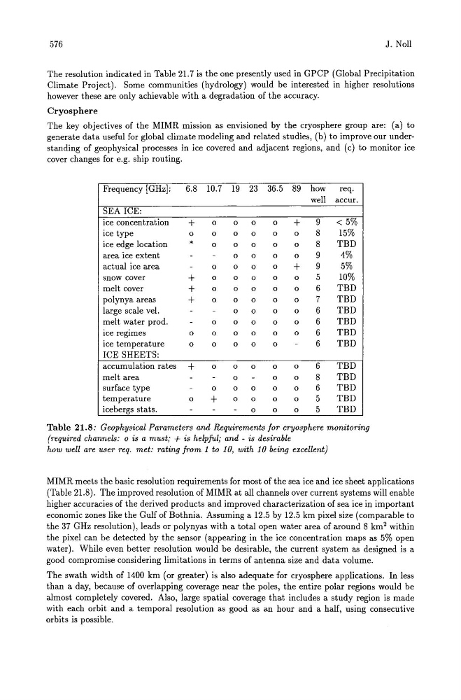
Table 21.8: Geophysical Parameters and Requirements for cryosphere monitoring
(required channels: 0 is a must; + is helpful; and - is desirable
how well are user req. met: rating from 1 to 10, with 10 being excellent)
MIMR meets the basic resolution requirements for most of the sea ice and ice sheet applications
(Table 21.8). The improved resolution of MIMR at all channels over current systems will enable
higher accuracies of the derived products and improved characterization of sea ice in important
economic zones like the Gulf of Bothnia. Assuming a 12.5 by 12.5 km pixel size (comparable to
the 37 GHz resolution), leads or polynyas with a total open water area of around 8 km 2 within
the pixel can be detected by the sensor (appearing in the ice concentration maps as 5% open
water). While even better resolution would be desirable, the current system as designed is a
good compromise considering limitations in terms of antenna size and data volume.
The swath width of 1400 km (or greater) is also adequate for cryosphere applications. In less
than a day, because of overlapping coverage near the poles, the entire polar regions would be
almost completely covered. Also, large spatial coverage that includes a study region is made
with each orbit and a temporal resolution as good as an hour and a half, using consecutive
orbits is possible.