

Model Development for Passive Microwave Remote Sensing ...
575
Geophysical parameter Application
Coverage Resol- Delivery Algorithm AcSpatial /
ution / time
Maturity curac
Temporal grid
Instantaneous precipi- Operational
Regional
17 km < 15 min Low
50%
tation over land
Meteorology /
Hydrology /
crop forecast
Instantaneous precipi- Operational
Global
17 km < 3 hours Low
50%
tation over land
Meteorology /
Hydrology /
crop forecast
Instantaneous precipi- Operational
Regional
17 km < 15 min Medium 50%
tation over ocean
Meteorology
Instantaneous precipi- Operational
Global
17 km < 3 hours Medium 50%
tation over ocean
Meteorology
Rain /
Other
Regional
17 km < 15 min Medium
No Rain Flag
instruments
to High
Rain /
Other
Global
17 km < 3 hours Medium
No Rain Flag
instruments
to High
Stratiform /
Operational
Regional
17 km < 15 min Low
to
Convective Flag
Meteorology
Medium
Stratiform /
Operational
Global
17 km < 3 hours Low
to
Convective Flag
Meteorology
Medium
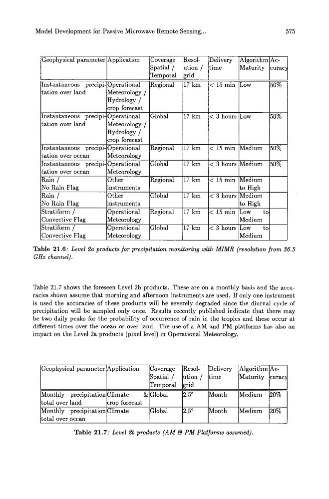
Table 21.6: Level 2a products for precipitation monitoring with MIMR (resolution from 36.5
GHz channel).
Table 21.7 shows the foreseen Level 2b products. These are on a monthly basis and the accuracies shown assume that morning and afternoon instruments are used. If only one instrument
is used the accuracies of these products will be severely degraded since the diurnal cycle of
precipitation will be sampled only once. Results recently published indicate that there may
be two daily peaks for the probability of occurrence of rain in the tropics and these occur at
different times over the ocean or over land. The use of a AM and PM platforms has also an
impact on the Level 2a products (pixel level) in Operational Meteorology.
Geophysical parameter Application
Coverage Resol- Delivery Algorithm AcSpatial /
ution / time
Maturity curac
Temporal grid
Monthly precipitation Climate
& Global
2.5 0
Month
Medium 20%
total over land
crop forecast
Monthly precipitation Climate
Global
2.5 0
Month
Medium 20%
total over ocean
Table 21.7: Level 2b products (AM (1 PM Platforms assumed).